 Note:
The expiration time in the watch graphic is amended if the watch is
replaced, cancelled or extended.
Note:
Note:
The expiration time in the watch graphic is amended if the watch is
replaced, cancelled or extended.
Note: Click for
Watch Status Reports.
SEL9
URGENT - IMMEDIATE BROADCAST REQUESTED
Tornado Watch Number 719...CORRECTED
NWS Storm Prediction Center Norman OK
105 AM CST Sun Dec 10 2023
CORRECTED FOR TIME ZONE
The NWS Storm Prediction Center has issued a
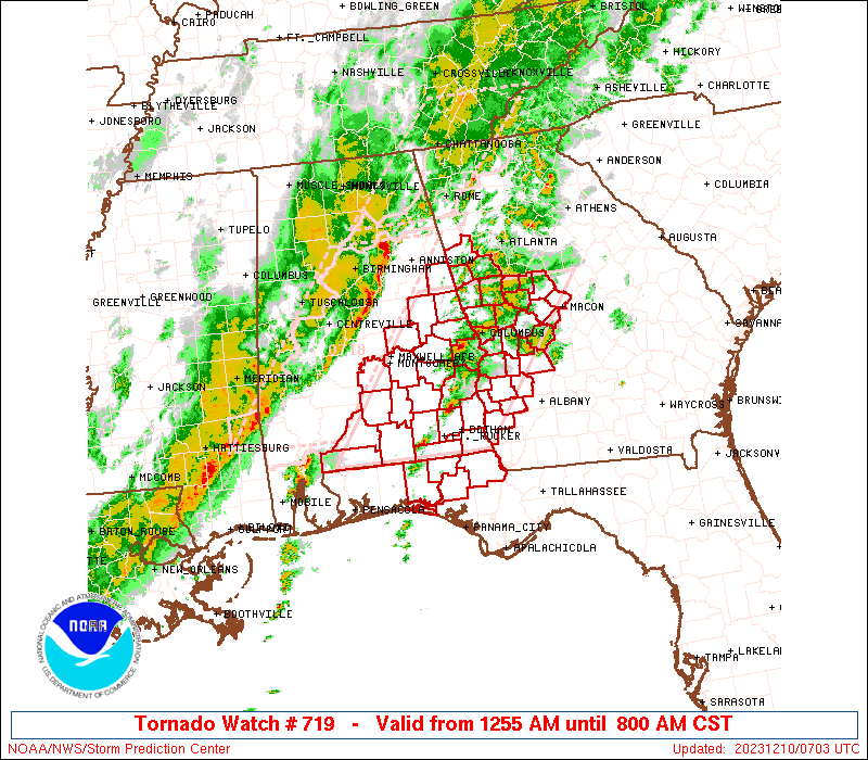
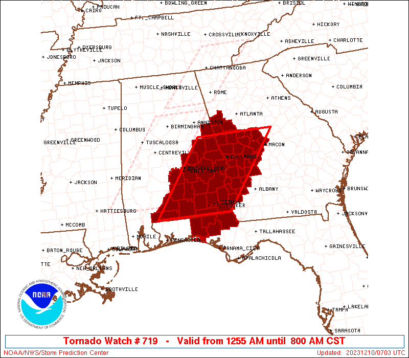
* Tornado Watch for portions of
Eastern Alabama
Parts of the Florida Panhandle
Western Georgia
* Effective this Sunday morning from 105 AM until 800 AM CST.
* Primary threats include...
A few tornadoes possible
Isolated damaging wind gusts to 70 mph possible
Isolated large hail events to 1.5 inches in diameter possible
SUMMARY...The severe-weather threat is increasing overnight as a
line of thunderstorms in tornado watch 718 approaches from the west,
and as cells ahead of the line near the AL/FL/GA tri-state region
gradually intensify.
The tornado watch area is approximately along and 70 statute miles
east and west of a line from 50 miles west southwest of Dothan AL to
30 miles east northeast of La Grange GA. For a complete depiction of
the watch see the associated watch outline update (WOUS64 KWNS
WOU9).
PRECAUTIONARY/PREPAREDNESS ACTIONS...
REMEMBER...A Tornado Watch means conditions are favorable for
tornadoes and severe thunderstorms in and close to the watch
area. Persons in these areas should be on the lookout for
threatening weather conditions and listen for later statements
and possible warnings.
&&
OTHER WATCH INFORMATION...CONTINUE...WW 717...WW 718...
AVIATION...Tornadoes and a few severe thunderstorms with hail
surface and aloft to 1.5 inches. Extreme turbulence and surface wind
gusts to 60 knots. A few cumulonimbi with maximum tops to 500. Mean
storm motion vector 23030.
...Edwards

   SEL9

   URGENT - IMMEDIATE BROADCAST REQUESTED
   Tornado Watch Number 719...CORRECTED
   NWS Storm Prediction Center Norman OK
   105 AM CST Sun Dec 10 2023

   CORRECTED FOR TIME ZONE

   The NWS Storm Prediction Center has issued a

   * Tornado Watch for portions of
     Eastern Alabama
     Parts of the Florida Panhandle
     Western Georgia

   * Effective this Sunday morning from 105 AM until 800 AM CST.

   * Primary threats include...
     A few tornadoes possible
     Isolated damaging wind gusts to 70 mph possible
     Isolated large hail events to 1.5 inches in diameter possible

   SUMMARY...The severe-weather threat is increasing overnight as a
   line of thunderstorms in tornado watch 718 approaches from the west,

   and as cells ahead of the line near the AL/FL/GA tri-state region
   gradually intensify.

   The tornado watch area is approximately along and 70 statute miles
   east and west of a line from 50 miles west southwest of Dothan AL to


   30 miles east northeast of La Grange GA. For a complete depiction of


   the watch see the associated watch outline update (WOUS64 KWNS
   WOU9).

   PRECAUTIONARY/PREPAREDNESS ACTIONS...

   REMEMBER...A Tornado Watch means conditions are favorable for
   tornadoes and severe thunderstorms in and close to the watch
   area. Persons in these areas should be on the lookout for
   threatening weather conditions and listen for later statements
   and possible warnings.

   &&

   OTHER WATCH INFORMATION...CONTINUE...WW 717...WW 718...

   AVIATION...Tornadoes and a few severe thunderstorms with hail
   surface and aloft to 1.5 inches. Extreme turbulence and surface wind

   gusts to 60 knots. A few cumulonimbi with maximum tops to 500. Mean
   storm motion vector 23030.

   ...Edwards
 Note:
The Aviation Watch (SAW) product is an approximation to the watch area.
The actual watch is depicted by the shaded areas.
Note:
The Aviation Watch (SAW) product is an approximation to the watch area.
The actual watch is depicted by the shaded areas.
   SAW9
   WW 719 TORNADO AL FL GA 100655Z - 101400Z
   AXIS..70 STATUTE MILES EAST AND WEST OF LINE..
   50WSW DHN/DOTHAN AL/ - 30ENE LGC/LA GRANGE GA/
   ..AVIATION COORDS.. 60NM E/W /26ENE CEW - 29SSW ATL/
   HAIL SURFACE AND ALOFT..1.5 INCHES. WIND GUSTS..60 KNOTS.
   MAX TOPS TO 500. MEAN STORM MOTION VECTOR 23030.

   LAT...LON 31048741 33168580 33168338 31048505

   THIS IS AN APPROXIMATION TO THE WATCH AREA.  FOR A
   COMPLETE DEPICTION OF THE WATCH SEE WOUS64 KWNS
   FOR WOU9.
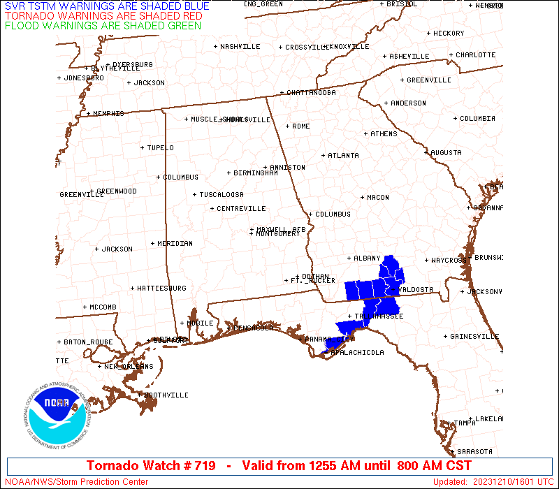
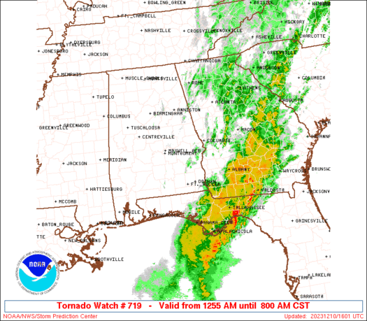
Watch 719 Status Report Messages:
STATUS REPORT #7 ON WW 719

VALID 101335Z - 101440Z

SEVERE WEATHER THREAT CONTINUES RIGHT OF A LINE FROM 25 SSE PFN
TO 35 E PFN TO 30 WSW ABY TO 35 WNW ABY TO 30 NNW ABY TO 35 NE
ABY.

FOR ADDITIONAL INFORMATION SEE MESOSCALE DISCUSSION 2323

..GLEASON..12/10/23

ATTN...WFO...BMX...MOB...TAE...FFC...

&&

STATUS REPORT FOR WT 719

SEVERE WEATHER THREAT CONTINUES FOR THE FOLLOWING AREAS

FLC013-037-039-045-065-073-077-129-101440-

FL
.    FLORIDA COUNTIES INCLUDED ARE

CALHOUN 	     FRANKLIN		 GADSDEN
GULF		     JEFFERSON		 LEON
LIBERTY 	     WAKULLA
$$


GAC007-037-071-087-095-131-177-201-205-243-273-275-277-287-321-
101440-

GA
.    GEORGIA COUNTIES INCLUDED ARE

BAKER		     CALHOUN		 COLQUITT
DECATUR 	     DOUGHERTY		 GRADY
LEE		     MILLER		 MITCHELL
RANDOLPH	     TERRELL		 THOMAS
TIFT		     TURNER		 WORTH
$$


THE WATCH STATUS MESSAGE IS FOR GUIDANCE PURPOSES ONLY.  PLEASE
REFER TO WATCH COUNTY NOTIFICATION STATEMENTS FOR OFFICIAL
INFORMATION ON COUNTIES...INDEPENDENT CITIES AND MARINE ZONES
CLEARED FROM SEVERE THUNDERSTORM AND TORNADO WATCHES.
$$

STATUS REPORT #6 ON WW 719

VALID 101240Z - 101340Z

SEVERE WEATHER THREAT CONTINUES RIGHT OF A LINE FROM 10 S PFN TO
25 NNE PFN TO 25 NNE DHN TO 35 SSE CSG TO 40 ENE CSG TO 40 NNE
MCN.

FOR ADDITIONAL INFORMATION SEE MESOSCALE DISCUSSION 2322

..GLEASON..12/10/23

ATTN...WFO...BMX...MOB...TAE...FFC...

&&

STATUS REPORT FOR WT 719

SEVERE WEATHER THREAT CONTINUES FOR THE FOLLOWING AREAS

ALC067-069-101340-

AL
.    ALABAMA COUNTIES INCLUDED ARE

HENRY		     HOUSTON
$$


FLC005-013-045-063-101340-

FL
.    FLORIDA COUNTIES INCLUDED ARE

BAY		     CALHOUN		 GULF
JACKSON
$$


GAC021-037-061-079-099-193-197-207-225-239-243-249-259-261-269-
273-293-307-101340-

GA
.    GEORGIA COUNTIES INCLUDED ARE

BIBB		     CALHOUN		 CLAY
CRAWFORD	     EARLY		 MACON
MARION		     MONROE		 PEACH
QUITMAN 	     RANDOLPH		 SCHLEY
STEWART 	     SUMTER		 TAYLOR
TERRELL 	     UPSON		 WEBSTER
$$


THE WATCH STATUS MESSAGE IS FOR GUIDANCE PURPOSES ONLY.  PLEASE
REFER TO WATCH COUNTY NOTIFICATION STATEMENTS FOR OFFICIAL
INFORMATION ON COUNTIES...INDEPENDENT CITIES AND MARINE ZONES
CLEARED FROM SEVERE THUNDERSTORM AND TORNADO WATCHES.
$$

STATUS REPORT #5 ON WW 719

VALID 101140Z - 101240Z

SEVERE WEATHER THREAT CONTINUES RIGHT OF A LINE FROM 30 SSE CEW
TO 35 NE CEW TO 20 ESE TOI TO 5 SSW CSG TO 20 ESE LGC TO 25 SSE
ATL.

..GLEASON..12/10/23

ATTN...WFO...BMX...MOB...TAE...FFC...

&&

STATUS REPORT FOR WT 719

SEVERE WEATHER THREAT CONTINUES FOR THE FOLLOWING AREAS

ALC005-031-045-061-067-069-113-101240-

AL
.    ALABAMA COUNTIES INCLUDED ARE

BARBOUR 	     COFFEE		 DALE
GENEVA		     HENRY		 HOUSTON
RUSSELL
$$


FLC005-013-045-059-063-091-131-133-101240-

FL
.    FLORIDA COUNTIES INCLUDED ARE

BAY		     CALHOUN		 GULF
HOLMES		     JACKSON		 OKALOOSA
WALTON		     WASHINGTON
$$


GAC021-037-053-061-079-099-145-171-193-197-199-207-215-225-231-
239-243-249-259-261-263-269-273-293-307-101240-

GA
.    GEORGIA COUNTIES INCLUDED ARE

BIBB		     CALHOUN		 CHATTAHOOCHEE
CLAY		     CRAWFORD		 EARLY
HARRIS		     LAMAR		 MACON
MARION		     MERIWETHER 	 MONROE
MUSCOGEE	     PEACH		 PIKE
QUITMAN 	     RANDOLPH		 SCHLEY
STEWART 	     SUMTER		 TALBOT
TAYLOR		     TERRELL		 UPSON
WEBSTER
$$


GMZ635-101240-

CW

.    ADJACENT COASTAL WATERS INCLUDED ARE

GMZ635

$$
THE WATCH STATUS MESSAGE IS FOR GUIDANCE PURPOSES ONLY.  PLEASE
REFER TO WATCH COUNTY NOTIFICATION STATEMENTS FOR OFFICIAL
INFORMATION ON COUNTIES...INDEPENDENT CITIES AND MARINE ZONES
CLEARED FROM SEVERE THUNDERSTORM AND TORNADO WATCHES.
$$

STATUS REPORT #4 ON WW 719

VALID 101035Z - 101140Z

SEVERE WEATHER THREAT CONTINUES RIGHT OF A LINE FROM 35 SSE CEW
TO 25 SW TOI TO 25 SSW AUO TO 5 W AUO TO 10 ESE LGC TO 25 S ATL.

FOR ADDITIONAL INFORMATION SEE MESOSCALE DISCUSSION 2321

..GLEASON..12/10/23

ATTN...WFO...BMX...MOB...TAE...FFC...

&&

STATUS REPORT FOR WT 719

SEVERE WEATHER THREAT CONTINUES FOR THE FOLLOWING AREAS

ALC005-011-031-039-041-045-061-067-069-081-087-109-113-101140-

AL
.    ALABAMA COUNTIES INCLUDED ARE

BARBOUR 	     BULLOCK		 COFFEE
COVINGTON	     CRENSHAW		 DALE
GENEVA		     HENRY		 HOUSTON
LEE		     MACON		 PIKE
RUSSELL
$$


FLC005-013-045-059-063-131-133-101140-

FL
.    FLORIDA COUNTIES INCLUDED ARE

BAY		     CALHOUN		 GULF
HOLMES		     JACKSON		 WALTON
WASHINGTON
$$


GAC021-037-053-061-079-099-145-171-193-197-199-207-215-225-231-
239-243-249-259-261-263-269-273-293-307-101140-

GA
.    GEORGIA COUNTIES INCLUDED ARE

BIBB		     CALHOUN		 CHATTAHOOCHEE
CLAY		     CRAWFORD		 EARLY
HARRIS		     LAMAR		 MACON
MARION		     MERIWETHER 	 MONROE
MUSCOGEE	     PEACH		 PIKE
QUITMAN 	     RANDOLPH		 SCHLEY
STEWART 	     SUMTER		 TALBOT
TAYLOR		     TERRELL		 UPSON
WEBSTER
$$


THE WATCH STATUS MESSAGE IS FOR GUIDANCE PURPOSES ONLY.  PLEASE
REFER TO WATCH COUNTY NOTIFICATION STATEMENTS FOR OFFICIAL
INFORMATION ON COUNTIES...INDEPENDENT CITIES AND MARINE ZONES
CLEARED FROM SEVERE THUNDERSTORM AND TORNADO WATCHES.
$$

STATUS REPORT #3 ON WW 719

VALID 100940Z - 101040Z

SEVERE WEATHER THREAT CONTINUES RIGHT OF A LINE FROM 10 NNW GZH
TO 25 SSW MGM TO 25 WSW AUO TO 10 SE LGC TO 20 WSW ATL.

..GLEASON..12/10/23

ATTN...WFO...BMX...MOB...TAE...FFC...

&&

STATUS REPORT FOR WT 719

SEVERE WEATHER THREAT CONTINUES FOR THE FOLLOWING AREAS

ALC005-011-013-031-035-039-041-045-053-061-067-069-081-087-101-
109-113-101040-

AL
.    ALABAMA COUNTIES INCLUDED ARE

BARBOUR 	     BULLOCK		 BUTLER
COFFEE		     CONECUH		 COVINGTON
CRENSHAW	     DALE		 ESCAMBIA
GENEVA		     HENRY		 HOUSTON
LEE		     MACON		 MONTGOMERY
PIKE		     RUSSELL
$$


FLC033-059-063-091-113-131-133-101040-

FL
.    FLORIDA COUNTIES INCLUDED ARE

ESCAMBIA	     HOLMES		 JACKSON
OKALOOSA	     SANTA ROSA 	 WALTON
WASHINGTON
$$


GAC021-037-053-061-077-079-099-145-171-193-197-199-207-215-225-
231-239-243-249-259-261-263-269-273-293-307-101040-

GA
.    GEORGIA COUNTIES INCLUDED ARE

BIBB		     CALHOUN		 CHATTAHOOCHEE
CLAY		     COWETA		 CRAWFORD
EARLY		     HARRIS		 LAMAR
MACON		     MARION		 MERIWETHER
MONROE		     MUSCOGEE		 PEACH
PIKE		     QUITMAN		 RANDOLPH
SCHLEY		     STEWART		 SUMTER
TALBOT		     TAYLOR		 TERRELL
UPSON		     WEBSTER
$$


THE WATCH STATUS MESSAGE IS FOR GUIDANCE PURPOSES ONLY.  PLEASE
REFER TO WATCH COUNTY NOTIFICATION STATEMENTS FOR OFFICIAL
INFORMATION ON COUNTIES...INDEPENDENT CITIES AND MARINE ZONES
CLEARED FROM SEVERE THUNDERSTORM AND TORNADO WATCHES.
$$

STATUS REPORT #2 ON WW 719

VALID 100840Z - 100940Z

THE SEVERE WEATHER THREAT CONTINUES ACROSS THE ENTIRE WATCH AREA.

FOR ADDITIONAL INFORMATION SEE MESOSCALE DISCUSSION 2320

..GLEASON..12/10/23

ATTN...WFO...BMX...MOB...TAE...FFC...

&&

STATUS REPORT FOR WT 719

SEVERE WEATHER THREAT CONTINUES FOR THE FOLLOWING AREAS

ALC005-011-013-017-031-035-039-041-045-051-053-061-067-069-081-
085-087-101-109-111-113-123-100940-

AL
.    ALABAMA COUNTIES INCLUDED ARE

BARBOUR 	     BULLOCK		 BUTLER
CHAMBERS	     COFFEE		 CONECUH
COVINGTON	     CRENSHAW		 DALE
ELMORE		     ESCAMBIA		 GENEVA
HENRY		     HOUSTON		 LEE
LOWNDES 	     MACON		 MONTGOMERY
PIKE		     RANDOLPH		 RUSSELL
TALLAPOOSA
$$


FLC033-059-063-091-113-131-133-100940-

FL
.    FLORIDA COUNTIES INCLUDED ARE

ESCAMBIA	     HOLMES		 JACKSON
OKALOOSA	     SANTA ROSA 	 WALTON
WASHINGTON
$$


GAC021-037-045-053-061-077-079-099-145-149-171-193-197-199-207-
215-225-231-239-243-249-259-261-263-269-273-285-293-307-
100940-

GA
.    GEORGIA COUNTIES INCLUDED ARE

BIBB		     CALHOUN		 CARROLL
CHATTAHOOCHEE	     CLAY		 COWETA
CRAWFORD	     EARLY		 HARRIS
HEARD		     LAMAR		 MACON
MARION		     MERIWETHER 	 MONROE
MUSCOGEE	     PEACH		 PIKE
QUITMAN 	     RANDOLPH		 SCHLEY
STEWART 	     SUMTER		 TALBOT
TAYLOR		     TERRELL		 TROUP
UPSON		     WEBSTER
$$


THE WATCH STATUS MESSAGE IS FOR GUIDANCE PURPOSES ONLY.  PLEASE
REFER TO WATCH COUNTY NOTIFICATION STATEMENTS FOR OFFICIAL
INFORMATION ON COUNTIES...INDEPENDENT CITIES AND MARINE ZONES
CLEARED FROM SEVERE THUNDERSTORM AND TORNADO WATCHES.
$$

STATUS REPORT #1 ON WW 719

VALID 100745Z - 100840Z

THE SEVERE WEATHER THREAT CONTINUES ACROSS THE ENTIRE WATCH AREA.

..GLEASON..12/10/23

ATTN...WFO...BMX...MOB...TAE...FFC...

&&

STATUS REPORT FOR WT 719

SEVERE WEATHER THREAT CONTINUES FOR THE FOLLOWING AREAS

ALC005-011-013-017-031-035-039-041-045-051-053-061-067-069-081-
085-087-101-109-111-113-123-100840-

AL
.    ALABAMA COUNTIES INCLUDED ARE

BARBOUR 	     BULLOCK		 BUTLER
CHAMBERS	     COFFEE		 CONECUH
COVINGTON	     CRENSHAW		 DALE
ELMORE		     ESCAMBIA		 GENEVA
HENRY		     HOUSTON		 LEE
LOWNDES 	     MACON		 MONTGOMERY
PIKE		     RANDOLPH		 RUSSELL
TALLAPOOSA
$$


FLC059-063-131-133-100840-

FL
.    FLORIDA COUNTIES INCLUDED ARE

HOLMES		     JACKSON		 WALTON
WASHINGTON
$$


GAC021-037-045-053-061-077-079-099-145-149-171-193-197-199-207-
215-225-231-239-243-249-259-261-263-269-273-285-293-307-
100840-

GA
.    GEORGIA COUNTIES INCLUDED ARE

BIBB		     CALHOUN		 CARROLL
CHATTAHOOCHEE	     CLAY		 COWETA
CRAWFORD	     EARLY		 HARRIS
HEARD		     LAMAR		 MACON
MARION		     MERIWETHER 	 MONROE
MUSCOGEE	     PEACH		 PIKE
QUITMAN 	     RANDOLPH		 SCHLEY
STEWART 	     SUMTER		 TALBOT
TAYLOR		     TERRELL		 TROUP
UPSON		     WEBSTER
$$


THE WATCH STATUS MESSAGE IS FOR GUIDANCE PURPOSES ONLY.  PLEASE
REFER TO WATCH COUNTY NOTIFICATION STATEMENTS FOR OFFICIAL
INFORMATION ON COUNTIES...INDEPENDENT CITIES AND MARINE ZONES
CLEARED FROM SEVERE THUNDERSTORM AND TORNADO WATCHES.
$$
Note:
Click for Complete Product Text.
Tornadoes
Probability of 2 or more tornadoes
|
Mod (50%)
|
Probability of 1 or more strong (EF2-EF5) tornadoes
|
Low (20%)
|
Wind
Probability of 10 or more severe wind events
|
Mod (30%)
|
Probability of 1 or more wind events > 65 knots
|
Low (10%)
|
Hail
Probability of 10 or more severe hail events
|
Low (20%)
|
Probability of 1 or more hailstones > 2 inches
|
Low (10%)
|
Combined Severe Hail/Wind
Probability of 6 or more combined severe hail/wind events
|
Mod (50%)
|
For each watch, probabilities for particular events inside the watch
(listed above in each table) are determined by the issuing forecaster.
The "Low" category contains probability values ranging from less than 2%
to 20% (EF2-EF5 tornadoes), less than 5% to 20% (all other probabilities),
"Moderate" from 30% to 60%, and "High" from 70% to greater than 95%.
High values are bolded and lighter in color to provide awareness of
an increased threat for a particular event.


 @NWSSPC