Note:
The expiration time in the watch graphic is amended if the watch is
replaced, cancelled or extended.
Note:
Note:
The expiration time in the watch graphic is amended if the watch is
replaced, cancelled or extended.
Note: Click for
Watch Status Reports.
SEL5
URGENT - IMMEDIATE BROADCAST REQUESTED
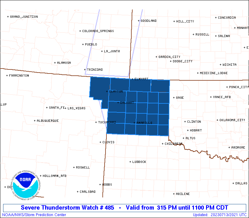
Severe Thunderstorm Watch Number 485
NWS Storm Prediction Center Norman OK
315 PM CDT Thu Jul 13 2023
The NWS Storm Prediction Center has issued a
* Severe Thunderstorm Watch for portions of
Northeast New Mexico
Oklahoma Panhandle
Texas Panhandle
* Effective this Thursday afternoon and evening from 315 PM until
1100 PM CDT.
* Primary threats include...
Scattered damaging wind gusts to 70 mph likely
Scattered large hail and isolated very large hail events to 2.5
inches in diameter possible
A tornado or two possible
SUMMARY...Isolated severe thunderstorms are expected to develop this
afternoon with a risk for very large hail and damaging wind gusts.
As storms increase in coverage this evening and merge into clusters,
damaging winds will become a more prominent severe weather hazard.
A tornado or two will also be possible.
The severe thunderstorm watch area is approximately along and 85
statute miles east and west of a line from 50 miles west northwest
of Guymon OK to 35 miles south southeast of Amarillo TX. For a
complete depiction of the watch see the associated watch outline
update (WOUS64 KWNS WOU5).
PRECAUTIONARY/PREPAREDNESS ACTIONS...
REMEMBER...A Severe Thunderstorm Watch means conditions are
favorable for severe thunderstorms in and close to the watch area.
Persons in these areas should be on the lookout for threatening
weather conditions and listen for later statements and possible
warnings. Severe thunderstorms can and occasionally do produce
tornadoes.
&&
OTHER WATCH INFORMATION...CONTINUE...WW 481...WW 482...WW
483...WW 484...
AVIATION...A few severe thunderstorms with hail surface and aloft to
2.5 inches. Extreme turbulence and surface wind gusts to 60 knots. A
few cumulonimbi with maximum tops to 550. Mean storm motion vector
29025.
...Bunting

   SEL5

   URGENT - IMMEDIATE BROADCAST REQUESTED
   Severe Thunderstorm Watch Number 485
   NWS Storm Prediction Center Norman OK
   315 PM CDT Thu Jul 13 2023

   The NWS Storm Prediction Center has issued a

   * Severe Thunderstorm Watch for portions of
     Northeast New Mexico
     Oklahoma Panhandle
     Texas Panhandle

   * Effective this Thursday afternoon and evening from 315 PM until
     1100 PM CDT.

   * Primary threats include...
     Scattered damaging wind gusts to 70 mph likely
     Scattered large hail and isolated very large hail events to 2.5
       inches in diameter possible
     A tornado or two possible

   SUMMARY...Isolated severe thunderstorms are expected to develop this
   afternoon with a risk for very large hail and damaging wind gusts.
   As storms increase in coverage this evening and merge into clusters,
   damaging winds will become a more prominent severe weather hazard.
   A tornado or two will also be possible.

   The severe thunderstorm watch area is approximately along and 85
   statute miles east and west of a line from 50 miles west northwest
   of Guymon OK to 35 miles south southeast of Amarillo TX. For a
   complete depiction of the watch see the associated watch outline
   update (WOUS64 KWNS WOU5).

   PRECAUTIONARY/PREPAREDNESS ACTIONS...

   REMEMBER...A Severe Thunderstorm Watch means conditions are
   favorable for severe thunderstorms in and close to the watch area.
   Persons in these areas should be on the lookout for threatening
   weather conditions and listen for later statements and possible
   warnings. Severe thunderstorms can and occasionally do produce
   tornadoes.

   &&

   OTHER WATCH INFORMATION...CONTINUE...WW 481...WW 482...WW
   483...WW 484...

   AVIATION...A few severe thunderstorms with hail surface and aloft to
   2.5 inches. Extreme turbulence and surface wind gusts to 60 knots. A
   few cumulonimbi with maximum tops to 550. Mean storm motion vector
   29025.

   ...Bunting
 Note:
The Aviation Watch (SAW) product is an approximation to the watch area.
The actual watch is depicted by the shaded areas.
Note:
The Aviation Watch (SAW) product is an approximation to the watch area.
The actual watch is depicted by the shaded areas.
   SAW5
   WW 485 SEVERE TSTM NM OK TX 132015Z - 140400Z
   AXIS..85 STATUTE MILES EAST AND WEST OF LINE..
   50WNW GUY/GUYMON OK/ - 35SSE AMA/AMARILLO TX/
   ..AVIATION COORDS.. 75NM E/W /63ESE TBE - 33SSE AMA/
   HAIL SURFACE AND ALOFT..2.5 INCHES. WIND GUSTS..60 KNOTS.
   MAX TOPS TO 550. MEAN STORM MOTION VECTOR 29025.

   LAT...LON 36930080 34749999 34740298 36930388

   THIS IS AN APPROXIMATION TO THE WATCH AREA.  FOR A
   COMPLETE DEPICTION OF THE WATCH SEE WOUS64 KWNS
   FOR WOU5.
Watch 485 Status Report Messages:
STATUS REPORT #7 ON WW 485

VALID 140320Z - 140440Z

THE SEVERE WEATHER THREAT CONTINUES ACROSS THE ENTIRE WATCH AREA.
PORTIONS OF WW 485 MAY BE EXTENDED PAST THE 04Z EXPIRATION TIME.

..DEAN..07/14/23

ATTN...WFO...ABQ...AMA...

&&

STATUS REPORT FOR WS 485

SEVERE WEATHER THREAT CONTINUES FOR THE FOLLOWING AREAS

NMC059-140440-

NM
.    NEW MEXICO COUNTIES INCLUDED ARE

UNION
$$


OKC007-025-139-140440-

OK
.    OKLAHOMA COUNTIES INCLUDED ARE

BEAVER		     CIMARRON		 TEXAS
$$


TXC011-065-087-111-117-129-179-195-205-211-233-295-341-357-359-
375-381-393-421-483-140440-

TX
.    TEXAS COUNTIES INCLUDED ARE

ARMSTRONG	     CARSON		 COLLINGSWORTH
DALLAM		     DEAF SMITH 	 DONLEY
GRAY		     HANSFORD		 HARTLEY
HEMPHILL	     HUTCHINSON 	 LIPSCOMB
MOORE		     OCHILTREE		 OLDHAM
POTTER		     RANDALL		 ROBERTS
SHERMAN 	     WHEELER
$$


THE WATCH STATUS MESSAGE IS FOR GUIDANCE PURPOSES ONLY.  PLEASE
REFER TO WATCH COUNTY NOTIFICATION STATEMENTS FOR OFFICIAL
INFORMATION ON COUNTIES...INDEPENDENT CITIES AND MARINE ZONES
CLEARED FROM SEVERE THUNDERSTORM AND TORNADO WATCHES.
$$

STATUS REPORT #6 ON WW 485

VALID 140155Z - 140240Z

THE SEVERE WEATHER THREAT CONTINUES ACROSS THE ENTIRE WATCH AREA.

..DEAN..07/14/23

ATTN...WFO...ABQ...AMA...

&&

STATUS REPORT FOR WS 485

SEVERE WEATHER THREAT CONTINUES FOR THE FOLLOWING AREAS

NMC059-140240-

NM
.    NEW MEXICO COUNTIES INCLUDED ARE

UNION
$$


OKC007-025-139-140240-

OK
.    OKLAHOMA COUNTIES INCLUDED ARE

BEAVER		     CIMARRON		 TEXAS
$$


TXC011-065-087-111-117-129-179-195-205-211-233-295-341-357-359-
375-381-393-421-483-140240-

TX
.    TEXAS COUNTIES INCLUDED ARE

ARMSTRONG	     CARSON		 COLLINGSWORTH
DALLAM		     DEAF SMITH 	 DONLEY
GRAY		     HANSFORD		 HARTLEY
HEMPHILL	     HUTCHINSON 	 LIPSCOMB
MOORE		     OCHILTREE		 OLDHAM
POTTER		     RANDALL		 ROBERTS
SHERMAN 	     WHEELER
$$


THE WATCH STATUS MESSAGE IS FOR GUIDANCE PURPOSES ONLY.  PLEASE
REFER TO WATCH COUNTY NOTIFICATION STATEMENTS FOR OFFICIAL
INFORMATION ON COUNTIES...INDEPENDENT CITIES AND MARINE ZONES
CLEARED FROM SEVERE THUNDERSTORM AND TORNADO WATCHES.
$$

STATUS REPORT #5 ON WW 485

VALID 140040Z - 140140Z

THE SEVERE WEATHER THREAT CONTINUES ACROSS THE ENTIRE WATCH AREA.

FOR ADDITIONAL INFORMATION SEE MESOSCALE DISCUSSION 1532

..DEAN..07/14/23

ATTN...WFO...ABQ...AMA...

&&

STATUS REPORT FOR WS 485

SEVERE WEATHER THREAT CONTINUES FOR THE FOLLOWING AREAS

NMC059-140140-

NM
.    NEW MEXICO COUNTIES INCLUDED ARE

UNION
$$


OKC007-025-139-140140-

OK
.    OKLAHOMA COUNTIES INCLUDED ARE

BEAVER		     CIMARRON		 TEXAS
$$


TXC011-065-087-111-117-129-179-195-205-211-233-295-341-357-359-
375-381-393-421-483-140140-

TX
.    TEXAS COUNTIES INCLUDED ARE

ARMSTRONG	     CARSON		 COLLINGSWORTH
DALLAM		     DEAF SMITH 	 DONLEY
GRAY		     HANSFORD		 HARTLEY
HEMPHILL	     HUTCHINSON 	 LIPSCOMB
MOORE		     OCHILTREE		 OLDHAM
POTTER		     RANDALL		 ROBERTS
SHERMAN 	     WHEELER
$$


THE WATCH STATUS MESSAGE IS FOR GUIDANCE PURPOSES ONLY.  PLEASE
REFER TO WATCH COUNTY NOTIFICATION STATEMENTS FOR OFFICIAL
INFORMATION ON COUNTIES...INDEPENDENT CITIES AND MARINE ZONES
CLEARED FROM SEVERE THUNDERSTORM AND TORNADO WATCHES.
$$

STATUS REPORT #4 ON WW 485

VALID 132345Z - 140040Z

THE SEVERE WEATHER THREAT CONTINUES ACROSS THE ENTIRE WATCH AREA.

FOR ADDITIONAL INFORMATION SEE MESOSCALE DISCUSSION 1532

..DEAN..07/13/23

ATTN...WFO...ABQ...AMA...

&&

STATUS REPORT FOR WS 485

SEVERE WEATHER THREAT CONTINUES FOR THE FOLLOWING AREAS

NMC059-140040-

NM
.    NEW MEXICO COUNTIES INCLUDED ARE

UNION
$$


OKC007-025-139-140040-

OK
.    OKLAHOMA COUNTIES INCLUDED ARE

BEAVER		     CIMARRON		 TEXAS
$$


TXC011-065-087-111-117-129-179-195-205-211-233-295-341-357-359-
375-381-393-421-483-140040-

TX
.    TEXAS COUNTIES INCLUDED ARE

ARMSTRONG	     CARSON		 COLLINGSWORTH
DALLAM		     DEAF SMITH 	 DONLEY
GRAY		     HANSFORD		 HARTLEY
HEMPHILL	     HUTCHINSON 	 LIPSCOMB
MOORE		     OCHILTREE		 OLDHAM
POTTER		     RANDALL		 ROBERTS
SHERMAN 	     WHEELER
$$


THE WATCH STATUS MESSAGE IS FOR GUIDANCE PURPOSES ONLY.  PLEASE
REFER TO WATCH COUNTY NOTIFICATION STATEMENTS FOR OFFICIAL
INFORMATION ON COUNTIES...INDEPENDENT CITIES AND MARINE ZONES
CLEARED FROM SEVERE THUNDERSTORM AND TORNADO WATCHES.
$$

STATUS REPORT #3 ON WW 485

VALID 132235Z - 132340Z

THE SEVERE WEATHER THREAT CONTINUES ACROSS THE ENTIRE WATCH AREA.

..KARSTENS..07/13/23

ATTN...WFO...ABQ...AMA...

&&

STATUS REPORT FOR WS 485

SEVERE WEATHER THREAT CONTINUES FOR THE FOLLOWING AREAS

NMC059-132340-

NM
.    NEW MEXICO COUNTIES INCLUDED ARE

UNION
$$


OKC007-025-139-132340-

OK
.    OKLAHOMA COUNTIES INCLUDED ARE

BEAVER		     CIMARRON		 TEXAS
$$


TXC011-065-087-111-117-129-179-195-205-211-233-295-341-357-359-
375-381-393-421-483-132340-

TX
.    TEXAS COUNTIES INCLUDED ARE

ARMSTRONG	     CARSON		 COLLINGSWORTH
DALLAM		     DEAF SMITH 	 DONLEY
GRAY		     HANSFORD		 HARTLEY
HEMPHILL	     HUTCHINSON 	 LIPSCOMB
MOORE		     OCHILTREE		 OLDHAM
POTTER		     RANDALL		 ROBERTS
SHERMAN 	     WHEELER
$$


THE WATCH STATUS MESSAGE IS FOR GUIDANCE PURPOSES ONLY.  PLEASE
REFER TO WATCH COUNTY NOTIFICATION STATEMENTS FOR OFFICIAL
INFORMATION ON COUNTIES...INDEPENDENT CITIES AND MARINE ZONES
CLEARED FROM SEVERE THUNDERSTORM AND TORNADO WATCHES.
$$

STATUS REPORT #2 ON WW 485

VALID 132140Z - 132240Z

THE SEVERE WEATHER THREAT CONTINUES ACROSS THE ENTIRE WATCH AREA.

..KARSTENS..07/13/23

ATTN...WFO...ABQ...AMA...

&&

STATUS REPORT FOR WS 485

SEVERE WEATHER THREAT CONTINUES FOR THE FOLLOWING AREAS

NMC059-132240-

NM
.    NEW MEXICO COUNTIES INCLUDED ARE

UNION
$$


OKC007-025-139-132240-

OK
.    OKLAHOMA COUNTIES INCLUDED ARE

BEAVER		     CIMARRON		 TEXAS
$$


TXC011-065-087-111-117-129-179-195-205-211-233-295-341-357-359-
375-381-393-421-483-132240-

TX
.    TEXAS COUNTIES INCLUDED ARE

ARMSTRONG	     CARSON		 COLLINGSWORTH
DALLAM		     DEAF SMITH 	 DONLEY
GRAY		     HANSFORD		 HARTLEY
HEMPHILL	     HUTCHINSON 	 LIPSCOMB
MOORE		     OCHILTREE		 OLDHAM
POTTER		     RANDALL		 ROBERTS
SHERMAN 	     WHEELER
$$


THE WATCH STATUS MESSAGE IS FOR GUIDANCE PURPOSES ONLY.  PLEASE
REFER TO WATCH COUNTY NOTIFICATION STATEMENTS FOR OFFICIAL
INFORMATION ON COUNTIES...INDEPENDENT CITIES AND MARINE ZONES
CLEARED FROM SEVERE THUNDERSTORM AND TORNADO WATCHES.
$$

STATUS REPORT #1 ON WW 485

VALID 132040Z - 132140Z

THE SEVERE WEATHER THREAT CONTINUES ACROSS THE ENTIRE WATCH AREA.

..KARSTENS..07/13/23

ATTN...WFO...ABQ...AMA...

&&

STATUS REPORT FOR WS 485

SEVERE WEATHER THREAT CONTINUES FOR THE FOLLOWING AREAS

NMC059-132140-

NM
.    NEW MEXICO COUNTIES INCLUDED ARE

UNION
$$


OKC007-025-139-132140-

OK
.    OKLAHOMA COUNTIES INCLUDED ARE

BEAVER		     CIMARRON		 TEXAS
$$


TXC011-065-087-111-117-129-179-195-205-211-233-295-341-357-359-
375-381-393-421-483-132140-

TX
.    TEXAS COUNTIES INCLUDED ARE

ARMSTRONG	     CARSON		 COLLINGSWORTH
DALLAM		     DEAF SMITH 	 DONLEY
GRAY		     HANSFORD		 HARTLEY
HEMPHILL	     HUTCHINSON 	 LIPSCOMB
MOORE		     OCHILTREE		 OLDHAM
POTTER		     RANDALL		 ROBERTS
SHERMAN 	     WHEELER
$$


THE WATCH STATUS MESSAGE IS FOR GUIDANCE PURPOSES ONLY.  PLEASE
REFER TO WATCH COUNTY NOTIFICATION STATEMENTS FOR OFFICIAL
INFORMATION ON COUNTIES...INDEPENDENT CITIES AND MARINE ZONES
CLEARED FROM SEVERE THUNDERSTORM AND TORNADO WATCHES.
$$
Note:
Click for Complete Product Text.
Tornadoes
Probability of 2 or more tornadoes
|
Low (20%)
|
Probability of 1 or more strong (EF2-EF5) tornadoes
|
Low (5%)
|
Wind
Probability of 10 or more severe wind events
|
Mod (60%)
|
Probability of 1 or more wind events > 65 knots
|
Low (20%)
|
Hail
Probability of 10 or more severe hail events
|
Mod (40%)
|
Probability of 1 or more hailstones > 2 inches
|
Mod (30%)
|
Combined Severe Hail/Wind
Probability of 6 or more combined severe hail/wind events
|
High (90%)
|
For each watch, probabilities for particular events inside the watch
(listed above in each table) are determined by the issuing forecaster.
The "Low" category contains probability values ranging from less than 2%
to 20% (EF2-EF5 tornadoes), less than 5% to 20% (all other probabilities),
"Moderate" from 30% to 60%, and "High" from 70% to greater than 95%.
High values are bolded and lighter in color to provide awareness of
an increased threat for a particular event.


 @NWSSPC