Note:
The expiration time in the watch graphic is amended if the watch is
replaced, cancelled or extended.
Note:
Note:
The expiration time in the watch graphic is amended if the watch is
replaced, cancelled or extended.
Note: Click for
Watch Status Reports.
SEL3
URGENT - IMMEDIATE BROADCAST REQUESTED
Severe Thunderstorm Watch Number 483
NWS Storm Prediction Center Norman OK
1225 PM MDT Thu Jul 13 2023
The NWS Storm Prediction Center has issued a
* Severe Thunderstorm Watch for portions of
Eastern Colorado
Far western Kansas
Extreme southwest Nebraska
* Effective this Thursday afternoon and evening from 1225 PM
until 800 PM MDT.
* Primary threats include...
Scattered large hail and isolated very large hail events to 2.5
inches in diameter possible
Scattered damaging wind gusts to 70 mph possible
A tornado or two possible
SUMMARY...Isolated severe thunderstorms will continue to develop
this afternoon, with storms becoming more numerous and merging into
clusters towards evening. Very large hail, up to the size of
baseballs, will be possible along with damaging winds. A tornado or
two may also occur. As storms merge into southeast-moving clusters,
damaging winds will become an increasing concern.
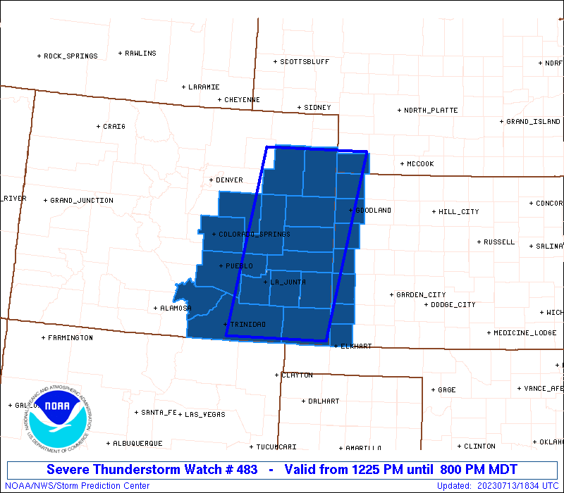
The severe thunderstorm watch area is approximately along and 60
statute miles east and west of a line from 40 miles east northeast
of Akron CO to 35 miles west southwest of Springfield CO. For a
complete depiction of the watch see the associated watch outline
update (WOUS64 KWNS WOU3).
PRECAUTIONARY/PREPAREDNESS ACTIONS...
REMEMBER...A Severe Thunderstorm Watch means conditions are
favorable for severe thunderstorms in and close to the watch area.
Persons in these areas should be on the lookout for threatening
weather conditions and listen for later statements and possible
warnings. Severe thunderstorms can and occasionally do produce
tornadoes.
&&
OTHER WATCH INFORMATION...CONTINUE...WW 481...WW 482...
AVIATION...A few severe thunderstorms with hail surface and aloft to
2.5 inches. Extreme turbulence and surface wind gusts to 60 knots. A
few cumulonimbi with maximum tops to 500. Mean storm motion vector
29025.
...Bunting

   SEL3

   URGENT - IMMEDIATE BROADCAST REQUESTED
   Severe Thunderstorm Watch Number 483
   NWS Storm Prediction Center Norman OK
   1225 PM MDT Thu Jul 13 2023

   The NWS Storm Prediction Center has issued a

   * Severe Thunderstorm Watch for portions of
     Eastern Colorado
     Far western Kansas
     Extreme southwest Nebraska

   * Effective this Thursday afternoon and evening from 1225 PM
     until 800 PM MDT.

   * Primary threats include...
     Scattered large hail and isolated very large hail events to 2.5
       inches in diameter possible
     Scattered damaging wind gusts to 70 mph possible
     A tornado or two possible

   SUMMARY...Isolated severe thunderstorms will continue to develop
   this afternoon, with storms becoming more numerous and merging into
   clusters towards evening. Very large hail, up to the size of
   baseballs, will be possible along with damaging winds.  A tornado or
   two may also occur.  As storms merge into southeast-moving clusters,
   damaging winds will become an increasing concern.

   The severe thunderstorm watch area is approximately along and 60
   statute miles east and west of a line from 40 miles east northeast
   of Akron CO to 35 miles west southwest of Springfield CO. For a
   complete depiction of the watch see the associated watch outline
   update (WOUS64 KWNS WOU3).

   PRECAUTIONARY/PREPAREDNESS ACTIONS...

   REMEMBER...A Severe Thunderstorm Watch means conditions are
   favorable for severe thunderstorms in and close to the watch area.
   Persons in these areas should be on the lookout for threatening
   weather conditions and listen for later statements and possible
   warnings. Severe thunderstorms can and occasionally do produce
   tornadoes.

   &&

   OTHER WATCH INFORMATION...CONTINUE...WW 481...WW 482...

   AVIATION...A few severe thunderstorms with hail surface and aloft to
   2.5 inches. Extreme turbulence and surface wind gusts to 60 knots. A
   few cumulonimbi with maximum tops to 500. Mean storm motion vector
   29025.

   ...Bunting
 Note:
The Aviation Watch (SAW) product is an approximation to the watch area.
The actual watch is depicted by the shaded areas.
Note:
The Aviation Watch (SAW) product is an approximation to the watch area.
The actual watch is depicted by the shaded areas.
   SAW3
   WW 483 SEVERE TSTM CO KS NE 131825Z - 140200Z
   AXIS..60 STATUTE MILES EAST AND WEST OF LINE..
   40ENE AKO/AKRON CO/ - 35WSW SPD/SPRINGFIELD CO/
   ..AVIATION COORDS.. 50NM E/W /34ENE AKO - 22ESE TBE/
   HAIL SURFACE AND ALOFT..2.5 INCHES. WIND GUSTS..60 KNOTS.
   MAX TOPS TO 500. MEAN STORM MOTION VECTOR 29025.

   LAT...LON 40390138 37080212 37080430 40390366

   THIS IS AN APPROXIMATION TO THE WATCH AREA.  FOR A
   COMPLETE DEPICTION OF THE WATCH SEE WOUS64 KWNS
   FOR WOU3.
Watch 483 Status Report Messages:
STATUS REPORT #6 ON WW 483

VALID 140030Z - 140140Z

THE SEVERE WEATHER THREAT CONTINUES ACROSS THE ENTIRE WATCH AREA.

..DEAN..07/14/23

ATTN...WFO...PUB...GLD...BOU...DDC...

&&

STATUS REPORT FOR WS 483

SEVERE WEATHER THREAT CONTINUES FOR THE FOLLOWING AREAS

COC017-039-041-055-063-073-101-121-125-140140-

CO
.    COLORADO COUNTIES INCLUDED ARE

CHEYENNE	     ELBERT		 EL PASO
HUERFANO	     KIT CARSON 	 LINCOLN
PUEBLO		     WASHINGTON 	 YUMA
$$


KSC023-071-181-199-140140-

KS
.    KANSAS COUNTIES INCLUDED ARE

CHEYENNE	     GREELEY		 SHERMAN
WALLACE
$$


NEC057-140140-

NE
.    NEBRASKA COUNTIES INCLUDED ARE

DUNDY
$$


THE WATCH STATUS MESSAGE IS FOR GUIDANCE PURPOSES ONLY.  PLEASE
REFER TO WATCH COUNTY NOTIFICATION STATEMENTS FOR OFFICIAL
INFORMATION ON COUNTIES...INDEPENDENT CITIES AND MARINE ZONES
CLEARED FROM SEVERE THUNDERSTORM AND TORNADO WATCHES.
$$

STATUS REPORT #5 ON WW 483

VALID 132340Z - 140040Z

THE SEVERE WEATHER THREAT CONTINUES ACROSS THE ENTIRE WATCH AREA.

..DEAN..07/13/23

ATTN...WFO...PUB...GLD...BOU...DDC...

&&

STATUS REPORT FOR WS 483

SEVERE WEATHER THREAT CONTINUES FOR THE FOLLOWING AREAS

COC017-039-041-055-063-073-101-121-125-140040-

CO
.    COLORADO COUNTIES INCLUDED ARE

CHEYENNE	     ELBERT		 EL PASO
HUERFANO	     KIT CARSON 	 LINCOLN
PUEBLO		     WASHINGTON 	 YUMA
$$


KSC023-071-181-199-140040-

KS
.    KANSAS COUNTIES INCLUDED ARE

CHEYENNE	     GREELEY		 SHERMAN
WALLACE
$$


NEC057-140040-

NE
.    NEBRASKA COUNTIES INCLUDED ARE

DUNDY
$$


THE WATCH STATUS MESSAGE IS FOR GUIDANCE PURPOSES ONLY.  PLEASE
REFER TO WATCH COUNTY NOTIFICATION STATEMENTS FOR OFFICIAL
INFORMATION ON COUNTIES...INDEPENDENT CITIES AND MARINE ZONES
CLEARED FROM SEVERE THUNDERSTORM AND TORNADO WATCHES.
$$

STATUS REPORT #4 ON WW 483

VALID 132230Z - 132340Z

THE SEVERE WEATHER THREAT CONTINUES ACROSS THE ENTIRE WATCH AREA.

FOR ADDITIONAL INFORMATION SEE MESOSCALE DISCUSSION 1530

..KARSTENS..07/13/23

ATTN...WFO...PUB...GLD...BOU...DDC...

&&

STATUS REPORT FOR WS 483

SEVERE WEATHER THREAT CONTINUES FOR THE FOLLOWING AREAS

COC009-011-017-025-039-041-055-061-063-071-073-089-099-101-121-
125-132340-

CO
.    COLORADO COUNTIES INCLUDED ARE

BACA		     BENT		 CHEYENNE
CROWLEY 	     ELBERT		 EL PASO
HUERFANO	     KIOWA		 KIT CARSON
LAS ANIMAS	     LINCOLN		 OTERO
PROWERS 	     PUEBLO		 WASHINGTON
YUMA
$$


KSC023-071-075-129-181-187-199-132340-

KS
.    KANSAS COUNTIES INCLUDED ARE

CHEYENNE	     GREELEY		 HAMILTON
MORTON		     SHERMAN		 STANTON
WALLACE
$$


NEC057-132340-

NE
.    NEBRASKA COUNTIES INCLUDED ARE

DUNDY
$$


THE WATCH STATUS MESSAGE IS FOR GUIDANCE PURPOSES ONLY.  PLEASE
REFER TO WATCH COUNTY NOTIFICATION STATEMENTS FOR OFFICIAL
INFORMATION ON COUNTIES...INDEPENDENT CITIES AND MARINE ZONES
CLEARED FROM SEVERE THUNDERSTORM AND TORNADO WATCHES.
$$

STATUS REPORT #3 ON WW 483

VALID 132135Z - 132240Z

THE SEVERE WEATHER THREAT CONTINUES ACROSS THE ENTIRE WATCH AREA.

..KARSTENS..07/13/23

ATTN...WFO...PUB...GLD...BOU...DDC...

&&

STATUS REPORT FOR WS 483

SEVERE WEATHER THREAT CONTINUES FOR THE FOLLOWING AREAS

COC009-011-017-025-039-041-055-061-063-071-073-089-099-101-121-
125-132240-

CO
.    COLORADO COUNTIES INCLUDED ARE

BACA		     BENT		 CHEYENNE
CROWLEY 	     ELBERT		 EL PASO
HUERFANO	     KIOWA		 KIT CARSON
LAS ANIMAS	     LINCOLN		 OTERO
PROWERS 	     PUEBLO		 WASHINGTON
YUMA
$$


KSC023-071-075-129-181-187-199-132240-

KS
.    KANSAS COUNTIES INCLUDED ARE

CHEYENNE	     GREELEY		 HAMILTON
MORTON		     SHERMAN		 STANTON
WALLACE
$$


NEC057-132240-

NE
.    NEBRASKA COUNTIES INCLUDED ARE

DUNDY
$$


THE WATCH STATUS MESSAGE IS FOR GUIDANCE PURPOSES ONLY.  PLEASE
REFER TO WATCH COUNTY NOTIFICATION STATEMENTS FOR OFFICIAL
INFORMATION ON COUNTIES...INDEPENDENT CITIES AND MARINE ZONES
CLEARED FROM SEVERE THUNDERSTORM AND TORNADO WATCHES.
$$

STATUS REPORT #2 ON WW 483

VALID 132040Z - 132140Z

THE SEVERE WEATHER THREAT CONTINUES ACROSS THE ENTIRE WATCH AREA.

..KARSTENS..07/13/23

ATTN...WFO...PUB...GLD...BOU...DDC...

&&

STATUS REPORT FOR WS 483

SEVERE WEATHER THREAT CONTINUES FOR THE FOLLOWING AREAS

COC009-011-017-025-039-041-055-061-063-071-073-089-099-101-121-
125-132140-

CO
.    COLORADO COUNTIES INCLUDED ARE

BACA		     BENT		 CHEYENNE
CROWLEY 	     ELBERT		 EL PASO
HUERFANO	     KIOWA		 KIT CARSON
LAS ANIMAS	     LINCOLN		 OTERO
PROWERS 	     PUEBLO		 WASHINGTON
YUMA
$$


KSC023-071-075-129-181-187-199-132140-

KS
.    KANSAS COUNTIES INCLUDED ARE

CHEYENNE	     GREELEY		 HAMILTON
MORTON		     SHERMAN		 STANTON
WALLACE
$$


NEC057-132140-

NE
.    NEBRASKA COUNTIES INCLUDED ARE

DUNDY
$$


THE WATCH STATUS MESSAGE IS FOR GUIDANCE PURPOSES ONLY.  PLEASE
REFER TO WATCH COUNTY NOTIFICATION STATEMENTS FOR OFFICIAL
INFORMATION ON COUNTIES...INDEPENDENT CITIES AND MARINE ZONES
CLEARED FROM SEVERE THUNDERSTORM AND TORNADO WATCHES.
$$

STATUS REPORT #1 ON WW 483

VALID 131935Z - 132040Z

THE SEVERE WEATHER THREAT CONTINUES ACROSS THE ENTIRE WATCH AREA.

..KARSTENS..07/13/23

ATTN...WFO...PUB...GLD...BOU...DDC...

&&

STATUS REPORT FOR WS 483

SEVERE WEATHER THREAT CONTINUES FOR THE FOLLOWING AREAS

COC009-011-017-025-039-041-055-061-063-071-073-089-099-101-121-
125-132040-

CO
.    COLORADO COUNTIES INCLUDED ARE

BACA		     BENT		 CHEYENNE
CROWLEY 	     ELBERT		 EL PASO
HUERFANO	     KIOWA		 KIT CARSON
LAS ANIMAS	     LINCOLN		 OTERO
PROWERS 	     PUEBLO		 WASHINGTON
YUMA
$$


KSC023-071-075-129-181-187-199-132040-

KS
.    KANSAS COUNTIES INCLUDED ARE

CHEYENNE	     GREELEY		 HAMILTON
MORTON		     SHERMAN		 STANTON
WALLACE
$$


NEC057-132040-

NE
.    NEBRASKA COUNTIES INCLUDED ARE

DUNDY
$$


THE WATCH STATUS MESSAGE IS FOR GUIDANCE PURPOSES ONLY.  PLEASE
REFER TO WATCH COUNTY NOTIFICATION STATEMENTS FOR OFFICIAL
INFORMATION ON COUNTIES...INDEPENDENT CITIES AND MARINE ZONES
CLEARED FROM SEVERE THUNDERSTORM AND TORNADO WATCHES.
$$
Note:
Click for Complete Product Text.
Tornadoes
Probability of 2 or more tornadoes
|
Low (20%)
|
Probability of 1 or more strong (EF2-EF5) tornadoes
|
Low (5%)
|
Wind
Probability of 10 or more severe wind events
|
Mod (40%)
|
Probability of 1 or more wind events > 65 knots
|
Low (20%)
|
Hail
Probability of 10 or more severe hail events
|
Mod (40%)
|
Probability of 1 or more hailstones > 2 inches
|
Mod (40%)
|
Combined Severe Hail/Wind
Probability of 6 or more combined severe hail/wind events
|
High (70%)
|
For each watch, probabilities for particular events inside the watch
(listed above in each table) are determined by the issuing forecaster.
The "Low" category contains probability values ranging from less than 2%
to 20% (EF2-EF5 tornadoes), less than 5% to 20% (all other probabilities),
"Moderate" from 30% to 60%, and "High" from 70% to greater than 95%.
High values are bolded and lighter in color to provide awareness of
an increased threat for a particular event.


 @NWSSPC