Note:
The expiration time in the watch graphic is amended if the watch is
replaced, cancelled or extended.
Note:
Note:
The expiration time in the watch graphic is amended if the watch is
replaced, cancelled or extended.
Note: Click for
Watch Status Reports.
SEL9
URGENT - IMMEDIATE BROADCAST REQUESTED
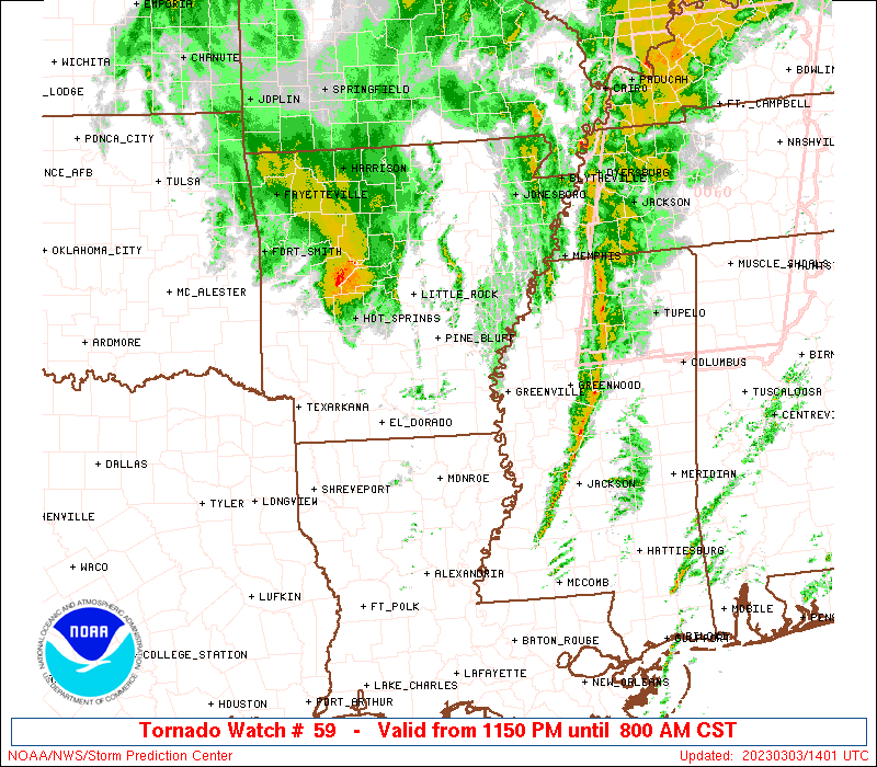
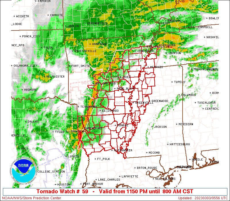
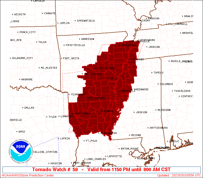
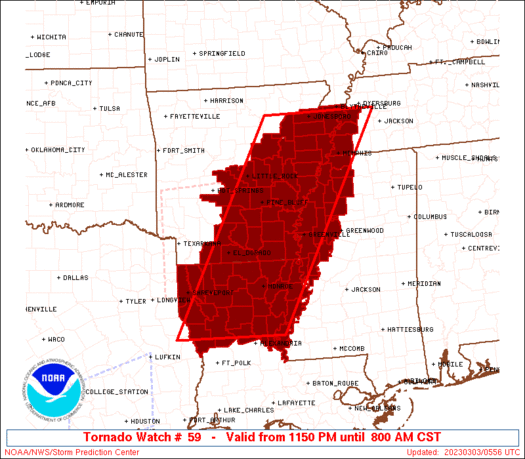
Tornado Watch Number 59
NWS Storm Prediction Center Norman OK
1150 PM CST Thu Mar 2 2023
The NWS Storm Prediction Center has issued a
* Tornado Watch for portions of
Central and eastern Arkansas
Northern Louisiana
Western and Northern Mississippi
Southwest Tennessee
* Effective this Thursday night and Friday morning from 1150 PM
until 800 AM CST.
* Primary threats include...
A few tornadoes likely with a couple intense tornadoes possible
Scattered damaging winds likely with isolated significant gusts
to 75 mph possible
Isolated large hail events to 1.5 inches in diameter possible
SUMMARY...A line of thunderstorms should continue to pose a threat
for damaging winds and tornadoes as it moves east-northeastward this
morning.
The tornado watch area is approximately along and 75 statute miles
east and west of a line from 15 miles east northeast of Jonesboro AR
to 20 miles southeast of Natchitoches LA. For a complete depiction
of the watch see the associated watch outline update (WOUS64 KWNS
WOU9).
PRECAUTIONARY/PREPAREDNESS ACTIONS...
REMEMBER...A Tornado Watch means conditions are favorable for
tornadoes and severe thunderstorms in and close to the watch
area. Persons in these areas should be on the lookout for
threatening weather conditions and listen for later statements
and possible warnings.
&&
OTHER WATCH INFORMATION...CONTINUE...WW 57...WW 58...
AVIATION...Tornadoes and a few severe thunderstorms with hail
surface and aloft to 1.5 inches. Extreme turbulence and surface wind
gusts to 65 knots. A few cumulonimbi with maximum tops to 500. Mean
storm motion vector 26040.
...Gleason/Guyer
 Note:
The Aviation Watch (SAW) product is an approximation to the watch area.
The actual watch is depicted by the shaded areas.
Note:
The Aviation Watch (SAW) product is an approximation to the watch area.
The actual watch is depicted by the shaded areas.
   SAW9
   WW 59 TORNADO AR LA MS TN 030550Z - 031400Z
   AXIS..75 STATUTE MILES EAST AND WEST OF LINE..
   15ENE JBR/JONESBORO AR/ - 20SE IER/NATCHITOCHES LA/
   ..AVIATION COORDS.. 65NM E/W /29ESE ARG - 25NW AEX/
   HAIL SURFACE AND ALOFT..1.5 INCHES. WIND GUSTS..65 KNOTS.
   MAX TOPS TO 500. MEAN STORM MOTION VECTOR 26040.

   LAT...LON 35918906 31539159 31539413 35919174

   THIS IS AN APPROXIMATION TO THE WATCH AREA.  FOR A
   COMPLETE DEPICTION OF THE WATCH SEE WOUS64 KWNS
   FOR WOU9.
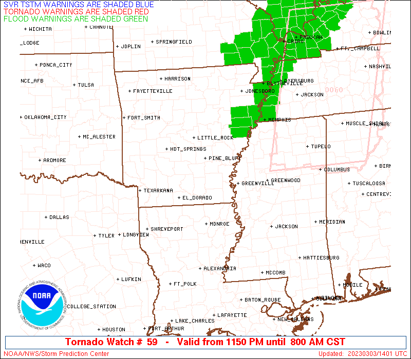
Watch 59 Status Report Messages:
STATUS REPORT #2 ON WW 59

VALID 031005Z - 031140Z

SEVERE WEATHER THREAT CONTINUES RIGHT OF A LINE FROM 20 NNE POE
TO 35 NNW MLU TO 30 ENE PBF TO 50 SSW JBR TO 5 ESE ARG.

..LEITMAN..03/03/23

ATTN...WFO...LZK...JAN...SHV...MEG...

&&

STATUS REPORT FOR WT 59

SEVERE WEATHER THREAT CONTINUES FOR THE FOLLOWING AREAS

ARC001-003-017-031-035-037-041-043-077-093-095-107-111-123-
031140-

AR
.    ARKANSAS COUNTIES INCLUDED ARE

ARKANSAS	     ASHLEY		 CHICOT
CRAIGHEAD	     CRITTENDEN 	 CROSS
DESHA		     DREW		 LEE
MISSISSIPPI	     MONROE		 PHILLIPS
POINSETT	     ST. FRANCIS
$$


LAC021-025-029-035-041-043-049-059-065-067-073-083-107-111-123-
127-031140-

LA
.    LOUISIANA PARISHES INCLUDED ARE

CALDWELL	     CATAHOULA		 CONCORDIA
EAST CARROLL	     FRANKLIN		 GRANT
JACKSON 	     LA SALLE		 MADISON
MOREHOUSE	     OUACHITA		 RICHLAND
TENSAS		     UNION		 WEST CARROLL
WINN
$$


MSC011-027-033-053-055-083-107-119-125-133-135-137-143-151-
031140-

MS
.    MISSISSIPPI COUNTIES INCLUDED ARE

BOLIVAR 	     COAHOMA		 DESOTO
HUMPHREYS	     ISSAQUENA		 LEFLORE
PANOLA		     QUITMAN		 SHARKEY
SUNFLOWER	     TALLAHATCHIE	 TATE
TUNICA		     WASHINGTON
$$


TNC097-157-167-031140-

TN
.    TENNESSEE COUNTIES INCLUDED ARE

LAUDERDALE	     SHELBY		 TIPTON
$$


THE WATCH STATUS MESSAGE IS FOR GUIDANCE PURPOSES ONLY.  PLEASE
REFER TO WATCH COUNTY NOTIFICATION STATEMENTS FOR OFFICIAL
INFORMATION ON COUNTIES...INDEPENDENT CITIES AND MARINE ZONES
CLEARED FROM SEVERE THUNDERSTORM AND TORNADO WATCHES.
$$

STATUS REPORT #1 ON WW 59

VALID 030730Z - 030840Z

SEVERE WEATHER THREAT CONTINUES RIGHT OF A LINE FROM 35 ENE LFK
TO 35 ESE SHV TO 45 SSE HOT TO 10 WSW LIT TO 25 N LIT.

..LEITMAN..03/03/23

ATTN...WFO...LZK...JAN...SHV...MEG...

&&

STATUS REPORT FOR WT 59

SEVERE WEATHER THREAT CONTINUES FOR THE FOLLOWING AREAS

ARC001-003-011-013-017-025-031-035-037-039-041-043-053-067-069-
077-079-085-093-095-103-107-111-117-119-123-139-145-147-
030840-

AR
.    ARKANSAS COUNTIES INCLUDED ARE

ARKANSAS	     ASHLEY		 BRADLEY
CALHOUN 	     CHICOT		 CLEVELAND
CRAIGHEAD	     CRITTENDEN 	 CROSS
DALLAS		     DESHA		 DREW
GRANT		     JACKSON		 JEFFERSON
LEE		     LINCOLN		 LONOKE
MISSISSIPPI	     MONROE		 OUACHITA
PHILLIPS	     POINSETT		 PRAIRIE
PULASKI 	     ST. FRANCIS	 UNION
WHITE		     WOODRUFF
$$


LAC013-021-025-027-029-031-035-041-043-049-059-061-065-067-069-
073-081-083-085-107-111-123-127-030840-

LA
.    LOUISIANA PARISHES INCLUDED ARE

BIENVILLE	     CALDWELL		 CATAHOULA
CLAIBORNE	     CONCORDIA		 DE SOTO
EAST CARROLL	     FRANKLIN		 GRANT
JACKSON 	     LA SALLE		 LINCOLN
MADISON 	     MOREHOUSE		 NATCHITOCHES
OUACHITA	     RED RIVER		 RICHLAND
SABINE		     TENSAS		 UNION
WEST CARROLL	     WINN
$$


MSC011-027-033-053-055-083-107-119-125-133-135-137-143-151-
030840-

MS
.    MISSISSIPPI COUNTIES INCLUDED ARE

BOLIVAR 	     COAHOMA		 DESOTO
HUMPHREYS	     ISSAQUENA		 LEFLORE
PANOLA		     QUITMAN		 SHARKEY
SUNFLOWER	     TALLAHATCHIE	 TATE
TUNICA		     WASHINGTON
$$


TNC097-157-167-030840-

TN
.    TENNESSEE COUNTIES INCLUDED ARE

LAUDERDALE	     SHELBY		 TIPTON
$$


THE WATCH STATUS MESSAGE IS FOR GUIDANCE PURPOSES ONLY.  PLEASE
REFER TO WATCH COUNTY NOTIFICATION STATEMENTS FOR OFFICIAL
INFORMATION ON COUNTIES...INDEPENDENT CITIES AND MARINE ZONES
CLEARED FROM SEVERE THUNDERSTORM AND TORNADO WATCHES.
$$
Note:
Click for Complete Product Text.
Tornadoes
Probability of 2 or more tornadoes
|
Mod (60%)
|
Probability of 1 or more strong (EF2-EF5) tornadoes
|
Mod (40%)
|
Wind
Probability of 10 or more severe wind events
|
High (70%)
|
Probability of 1 or more wind events > 65 knots
|
Mod (50%)
|
Hail
Probability of 10 or more severe hail events
|
Low (20%)
|
Probability of 1 or more hailstones > 2 inches
|
Low (10%)
|
Combined Severe Hail/Wind
Probability of 6 or more combined severe hail/wind events
|
High (90%)
|
For each watch, probabilities for particular events inside the watch
(listed above in each table) are determined by the issuing forecaster.
The "Low" category contains probability values ranging from less than 2%
to 20% (EF2-EF5 tornadoes), less than 5% to 20% (all other probabilities),
"Moderate" from 30% to 60%, and "High" from 70% to greater than 95%.
High values are bolded and lighter in color to provide awareness of
an increased threat for a particular event.


 @NWSSPC