Note:
The expiration time in the watch graphic is amended if the watch is
replaced, cancelled or extended.
Note:
Note:
The expiration time in the watch graphic is amended if the watch is
replaced, cancelled or extended.
Note: Click for
Watch Status Reports.
SEL8
URGENT - IMMEDIATE BROADCAST REQUESTED
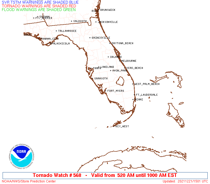
Tornado Watch Number 568
NWS Storm Prediction Center Norman OK
520 AM EST Tue Dec 21 2021
The NWS Storm Prediction Center has issued a
* Tornado Watch for portions of
Southwest Florida
Coastal Waters
* Effective this Tuesday morning from 520 AM until 1000 AM EST.
* Primary threats include...
A couple tornadoes possible
Isolated damaging wind gusts to 70 mph possible
SUMMARY...A long-lived supercell west of Naples may be maintained as
it reaches and spreads inland of the coast. An additional supercell
might develop farther north as well as low-level flow intensifies
this morning.
The tornado watch area is approximately along and 50 statute miles
either side of a line from 20 miles southwest of Fort Myers FL to 55
miles east northeast of Fort Myers FL. For a complete depiction of
the watch see the associated watch outline update (WOUS64 KWNS
WOU8).
PRECAUTIONARY/PREPAREDNESS ACTIONS...
REMEMBER...A Tornado Watch means conditions are favorable for
tornadoes and severe thunderstorms in and close to the watch
area. Persons in these areas should be on the lookout for
threatening weather conditions and listen for later statements
and possible warnings.
&&
AVIATION...Tornadoes and a few severe thunderstorms with hail
surface and aloft to 1.5 inches. Extreme turbulence and surface wind
gusts to 60 knots. A few cumulonimbi with maximum tops to 500. Mean
storm motion vector 24025.
...Grams
 Note:
The Aviation Watch (SAW) product is an approximation to the watch area.
The actual watch is depicted by the shaded areas.
Note:
The Aviation Watch (SAW) product is an approximation to the watch area.
The actual watch is depicted by the shaded areas.
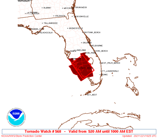
   SAW8
   WW 568 TORNADO FL CW 211020Z - 211500Z
   AXIS..50 STATUTE MILES EITHER SIDE OF LINE..
   20SW FMY/FORT MYERS FL/ - 55ENE FMY/FORT MYERS FL/
   ..AVIATION COORDS.. 45NM EITHER SIDE /19WSW RSW - 45ENE RSW/
   HAIL SURFACE AND ALOFT..1.5 INCHES. WIND GUSTS..60 KNOTS.
   MAX TOPS TO 500. MEAN STORM MOTION VECTOR 24025.

   LAT...LON 27058238 27568133 26208076 25708182

   THIS IS AN APPROXIMATION TO THE WATCH AREA.  FOR A
   COMPLETE DEPICTION OF THE WATCH SEE WOUS64 KWNS
   FOR WOU8.
Watch 568 Status Report Messages:
STATUS REPORT #1 ON WW 568

VALID 211445Z - 211500Z

SEVERE WEATHER THREAT CONTINUES RIGHT OF A LINE FROM 55 SE APF TO
40 WSW PBI.

WW 568 WILL BE ALLOWED TO EXPIRE AT 211500Z.

FOR ADDITIONAL INFORMATION SEE MESOSCALE DISCUSSION 2052

..WEINMAN..12/21/21

ATTN...WFO...TBW...MFL...

&&

STATUS REPORT FOR WT 568

SEVERE WEATHER THREAT CONTINUES FOR THE FOLLOWING AREAS

FLC021-211500-

FL
.    FLORIDA COUNTIES INCLUDED ARE

COLLIER
$$


THE WATCH STATUS MESSAGE IS FOR GUIDANCE PURPOSES ONLY.  PLEASE
REFER TO WATCH COUNTY NOTIFICATION STATEMENTS FOR OFFICIAL
INFORMATION ON COUNTIES...INDEPENDENT CITIES AND MARINE ZONES
CLEARED FROM SEVERE THUNDERSTORM AND TORNADO WATCHES.
$$
Note:
Click for Complete Product Text.
Tornadoes
Probability of 2 or more tornadoes
|
Mod (30%)
|
Probability of 1 or more strong (EF2-EF5) tornadoes
|
Low (20%)
|
Wind
Probability of 10 or more severe wind events
|
Low (20%)
|
Probability of 1 or more wind events > 65 knots
|
Low (20%)
|
Hail
Probability of 10 or more severe hail events
|
Low (10%)
|
Probability of 1 or more hailstones > 2 inches
|
Low (10%)
|
Combined Severe Hail/Wind
Probability of 6 or more combined severe hail/wind events
|
Mod (40%)
|
For each watch, probabilities for particular events inside the watch
(listed above in each table) are determined by the issuing forecaster.
The "Low" category contains probability values ranging from less than 2%
to 20% (EF2-EF5 tornadoes), less than 5% to 20% (all other probabilities),
"Moderate" from 30% to 60%, and "High" from 70% to greater than 95%.
High values are bolded and lighter in color to provide awareness of
an increased threat for a particular event.


 @NWSSPC