 Note:
The expiration time in the watch graphic is amended if the watch is
replaced, cancelled or extended.
Note:
Note:
The expiration time in the watch graphic is amended if the watch is
replaced, cancelled or extended.
Note: Click for
Watch Status Reports.
SEL7
URGENT - IMMEDIATE BROADCAST REQUESTED
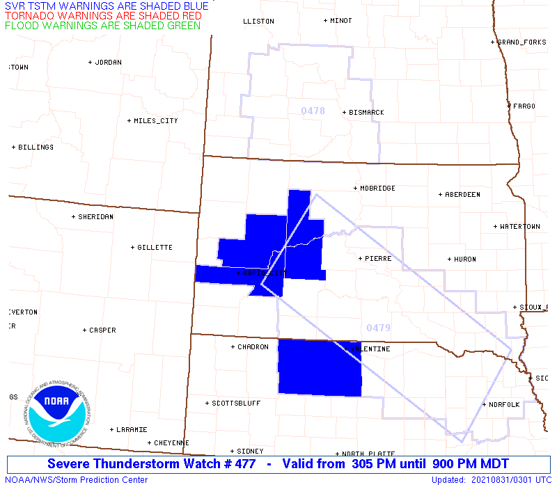
Severe Thunderstorm Watch Number 477
NWS Storm Prediction Center Norman OK
305 PM MDT Mon Aug 30 2021
The NWS Storm Prediction Center has issued a
* Severe Thunderstorm Watch for portions of
Westner to central South Dakota
* Effective this Monday afternoon and evening from 305 PM until
900 PM MDT.
* Primary threats include...
Scattered large hail and isolated very large hail events to 2.5
inches in diameter possible
Isolated significant damaging wind gusts to 75 mph possible
A tornado or two possible
SUMMARY...A couple supercells may develop from the Black Hills to
the South Dakota-North Dakota border area this evening.
The severe thunderstorm watch area is approximately along and 60
statute miles east and west of a line from 40 miles northwest of
Mobridge SD to 55 miles south southeast of Rapid City SD. For a
complete depiction of the watch see the associated watch outline
update (WOUS64 KWNS WOU7).
PRECAUTIONARY/PREPAREDNESS ACTIONS...
REMEMBER...A Severe Thunderstorm Watch means conditions are
favorable for severe thunderstorms in and close to the watch area.
Persons in these areas should be on the lookout for threatening
weather conditions and listen for later statements and possible
warnings. Severe thunderstorms can and occasionally do produce
tornadoes.
&&
OTHER WATCH INFORMATION...CONTINUE...WW 475...WW 476...
AVIATION...A few severe thunderstorms with hail surface and aloft to
2.5 inches. Extreme turbulence and surface wind gusts to 65 knots. A
few cumulonimbi with maximum tops to 550. Mean storm motion vector
32025.
...Grams
 Note:
The Aviation Watch (SAW) product is an approximation to the watch area.
The actual watch is depicted by the shaded areas.
Note:
The Aviation Watch (SAW) product is an approximation to the watch area.
The actual watch is depicted by the shaded areas.
SAW7
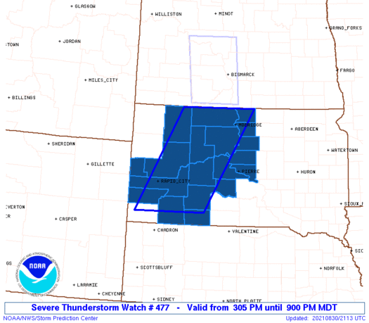
WW 477 SEVERE TSTM SD 302105Z - 310300Z
AXIS..60 STATUTE MILES EAST AND WEST OF LINE..
40NW MBG/MOBRIDGE SD/ - 55SSE RAP/RAPID CITY SD/
..AVIATION COORDS.. 50NM E/W /52SSW BIS - 43SSE RAP/
HAIL SURFACE AND ALOFT..2.5 INCHES. WIND GUSTS..65 KNOTS.
MAX TOPS TO 550. MEAN STORM MOTION VECTOR 32025.
LAT...LON 45939977 43310144 43310382 45930227
THIS IS AN APPROXIMATION TO THE WATCH AREA. FOR A
COMPLETE DEPICTION OF THE WATCH SEE WOUS64 KWNS
FOR WOU7.
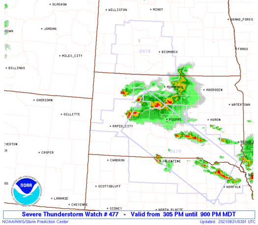
Watch 477 Status Report Messages:
STATUS REPORT #4 ON WW 477

VALID 310145Z - 310240Z

SEVERE WEATHER THREAT CONTINUES RIGHT OF A LINE FROM 20 NNW CDR
TO 15 WNW Y22.

..LEITMAN..08/31/21

ATTN...WFO...UNR...ABR...

&&

STATUS REPORT FOR WS 477

SEVERE WEATHER THREAT CONTINUES FOR THE FOLLOWING AREAS

SDC007-021-031-041-055-065-071-075-093-102-103-105-107-117-119-
129-137-310240-

SD
.    SOUTH DAKOTA COUNTIES INCLUDED ARE

BENNETT 	     CAMPBELL		 CORSON
DEWEY		     HAAKON		 HUGHES
JACKSON 	     JONES		 MEADE
OGLALA LAKOTA	     PENNINGTON 	 PERKINS
POTTER		     STANLEY		 SULLY
WALWORTH	     ZIEBACH
$$


THE WATCH STATUS MESSAGE IS FOR GUIDANCE PURPOSES ONLY.  PLEASE
REFER TO WATCH COUNTY NOTIFICATION STATEMENTS FOR OFFICIAL
INFORMATION ON COUNTIES...INDEPENDENT CITIES AND MARINE ZONES
CLEARED FROM SEVERE THUNDERSTORM AND TORNADO WATCHES.
$$

STATUS REPORT #3 ON WW 477

VALID 310030Z - 310140Z

THE SEVERE WEATHER THREAT CONTINUES ACROSS THE ENTIRE WATCH AREA.

FOR ADDITIONAL INFORMATION SEE MESOSCALE DISCUSSION 1655.

..LEITMAN..08/31/21

ATTN...WFO...UNR...ABR...

&&

STATUS REPORT FOR WS 477

SEVERE WEATHER THREAT CONTINUES FOR THE FOLLOWING AREAS

SDC007-021-031-033-041-055-065-071-075-081-093-102-103-105-107-
117-119-129-137-310140-

SD
.    SOUTH DAKOTA COUNTIES INCLUDED ARE

BENNETT 	     CAMPBELL		 CORSON
CUSTER		     DEWEY		 HAAKON
HUGHES		     JACKSON		 JONES
LAWRENCE	     MEADE		 OGLALA LAKOTA
PENNINGTON	     PERKINS		 POTTER
STANLEY 	     SULLY		 WALWORTH
ZIEBACH
$$


THE WATCH STATUS MESSAGE IS FOR GUIDANCE PURPOSES ONLY.  PLEASE
REFER TO WATCH COUNTY NOTIFICATION STATEMENTS FOR OFFICIAL
INFORMATION ON COUNTIES...INDEPENDENT CITIES AND MARINE ZONES
CLEARED FROM SEVERE THUNDERSTORM AND TORNADO WATCHES.
$$

STATUS REPORT #2 ON WW 477

VALID 302335Z - 310040Z

THE SEVERE WEATHER THREAT CONTINUES ACROSS THE ENTIRE WATCH AREA.

..LEITMAN..08/30/21

ATTN...WFO...UNR...ABR...

&&

STATUS REPORT FOR WS 477

SEVERE WEATHER THREAT CONTINUES FOR THE FOLLOWING AREAS

SDC007-021-031-033-041-055-065-071-075-081-093-102-103-105-107-
117-119-129-137-310040-

SD
.    SOUTH DAKOTA COUNTIES INCLUDED ARE

BENNETT 	     CAMPBELL		 CORSON
CUSTER		     DEWEY		 HAAKON
HUGHES		     JACKSON		 JONES
LAWRENCE	     MEADE		 OGLALA LAKOTA
PENNINGTON	     PERKINS		 POTTER
STANLEY 	     SULLY		 WALWORTH
ZIEBACH
$$


THE WATCH STATUS MESSAGE IS FOR GUIDANCE PURPOSES ONLY.  PLEASE
REFER TO WATCH COUNTY NOTIFICATION STATEMENTS FOR OFFICIAL
INFORMATION ON COUNTIES...INDEPENDENT CITIES AND MARINE ZONES
CLEARED FROM SEVERE THUNDERSTORM AND TORNADO WATCHES.
$$

STATUS REPORT #1 ON WW 477

VALID 302230Z - 302340Z

THE SEVERE WEATHER THREAT CONTINUES ACROSS THE ENTIRE WATCH AREA.

..LEITMAN..08/30/21

ATTN...WFO...UNR...ABR...

&&

STATUS REPORT FOR WS 477

SEVERE WEATHER THREAT CONTINUES FOR THE FOLLOWING AREAS

SDC007-021-031-033-041-055-065-071-075-081-093-102-103-105-107-
117-119-129-137-302340-

SD
.    SOUTH DAKOTA COUNTIES INCLUDED ARE

BENNETT 	     CAMPBELL		 CORSON
CUSTER		     DEWEY		 HAAKON
HUGHES		     JACKSON		 JONES
LAWRENCE	     MEADE		 OGLALA LAKOTA
PENNINGTON	     PERKINS		 POTTER
STANLEY 	     SULLY		 WALWORTH
ZIEBACH
$$


THE WATCH STATUS MESSAGE IS FOR GUIDANCE PURPOSES ONLY.  PLEASE
REFER TO WATCH COUNTY NOTIFICATION STATEMENTS FOR OFFICIAL
INFORMATION ON COUNTIES...INDEPENDENT CITIES AND MARINE ZONES
CLEARED FROM SEVERE THUNDERSTORM AND TORNADO WATCHES.
$$
Note:
Click for Complete Product Text.
Tornadoes
Probability of 2 or more tornadoes
|
Low (20%)
|
Probability of 1 or more strong (EF2-EF5) tornadoes
|
Low (5%)
|
Wind
Probability of 10 or more severe wind events
|
Mod (30%)
|
Probability of 1 or more wind events > 65 knots
|
Mod (30%)
|
Hail
Probability of 10 or more severe hail events
|
Mod (40%)
|
Probability of 1 or more hailstones > 2 inches
|
Mod (40%)
|
Combined Severe Hail/Wind
Probability of 6 or more combined severe hail/wind events
|
High (70%)
|
For each watch, probabilities for particular events inside the watch
(listed above in each table) are determined by the issuing forecaster.
The "Low" category contains probability values ranging from less than 2%
to 20% (EF2-EF5 tornadoes), less than 5% to 20% (all other probabilities),
"Moderate" from 30% to 60%, and "High" from 70% to greater than 95%.
High values are bolded and lighter in color to provide awareness of
an increased threat for a particular event.


 @NWSSPC