 Note:
The expiration time in the watch graphic is amended if the watch is
replaced, cancelled or extended.
Note:
Note:
The expiration time in the watch graphic is amended if the watch is
replaced, cancelled or extended.
Note: Click for
Watch Status Reports.
SEL5
URGENT - IMMEDIATE BROADCAST REQUESTED
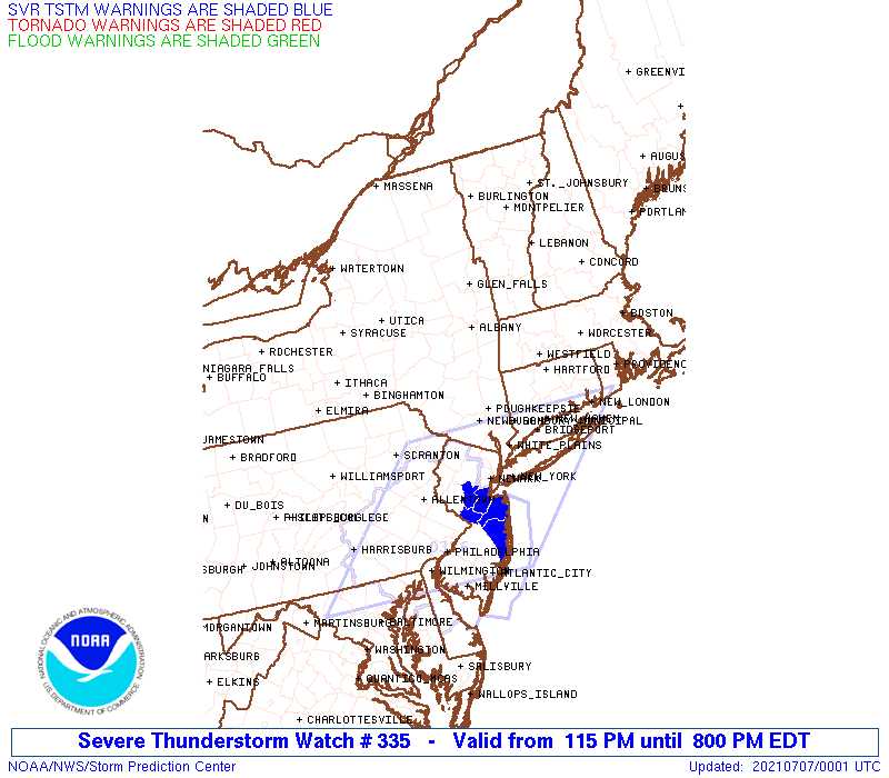
Severe Thunderstorm Watch Number 335
NWS Storm Prediction Center Norman OK
115 PM EDT Tue Jul 6 2021
The NWS Storm Prediction Center has issued a
* Severe Thunderstorm Watch for portions of
Connecticut
Massachusetts
Southern New Hampshire
Southern New York
Northern Pennsylvania
Rhode Island
Southern Vermont
Coastal Waters
* Effective this Tuesday afternoon and evening from 115 PM until
800 PM EDT.
* Primary threats include...
Scattered damaging wind gusts to 65 mph likely
Isolated large hail events to 1 inch in diameter possible
SUMMARY...Clusters of storms will continue to develop and intensify
and generally move east-southeastward across the region through late
afternoon and early evening. Although some hail is possible,
damaging thunderstorm winds will be the most common hazard.
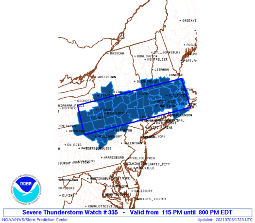
The severe thunderstorm watch area is approximately along and 50
statute miles north and south of a line from 35 miles west of Elmira
NY to 25 miles southeast of Boston MA. For a complete depiction of
the watch see the associated watch outline update (WOUS64 KWNS
WOU5).
PRECAUTIONARY/PREPAREDNESS ACTIONS...
REMEMBER...A Severe Thunderstorm Watch means conditions are
favorable for severe thunderstorms in and close to the watch area.
Persons in these areas should be on the lookout for threatening
weather conditions and listen for later statements and possible
warnings. Severe thunderstorms can and occasionally do produce
tornadoes.
&&
AVIATION...A few severe thunderstorms with hail surface and aloft to
1 inch. Extreme turbulence and surface wind gusts to 55 knots. A few
cumulonimbi with maximum tops to 500. Mean storm motion vector
31025.
...Guyer
   SEL5

   URGENT - IMMEDIATE BROADCAST REQUESTED
   Severe Thunderstorm Watch Number 335
   NWS Storm Prediction Center Norman OK
   115 PM EDT Tue Jul 6 2021

   The NWS Storm Prediction Center has issued a

   * Severe Thunderstorm Watch for portions of
     Connecticut
     Massachusetts
     Southern New Hampshire
     Southern New York
     Northern Pennsylvania
     Rhode Island
     Southern Vermont
     Coastal Waters

   * Effective this Tuesday afternoon and evening from 115 PM until
     800 PM EDT.

   * Primary threats include...
     Scattered damaging wind gusts to 65 mph likely
     Isolated large hail events to 1 inch in diameter possible

   SUMMARY...Clusters of storms will continue to develop and intensify
   and generally move east-southeastward across the region through late
   afternoon and early evening. Although some hail is possible,
   damaging thunderstorm winds will be the most common hazard.

   The severe thunderstorm watch area is approximately along and 50
   statute miles north and south of a line from 35 miles west of Elmira
   NY to 25 miles southeast of Boston MA. For a complete depiction of
   the watch see the associated watch outline update (WOUS64 KWNS
   WOU5).

   PRECAUTIONARY/PREPAREDNESS ACTIONS...

   REMEMBER...A Severe Thunderstorm Watch means conditions are
   favorable for severe thunderstorms in and close to the watch area.
   Persons in these areas should be on the lookout for threatening
   weather conditions and listen for later statements and possible
   warnings. Severe thunderstorms can and occasionally do produce
   tornadoes.

   &&

   AVIATION...A few severe thunderstorms with hail surface and aloft to
   1 inch. Extreme turbulence and surface wind gusts to 55 knots. A few
   cumulonimbi with maximum tops to 500. Mean storm motion vector
   31025.

   ...Guyer
 Note:
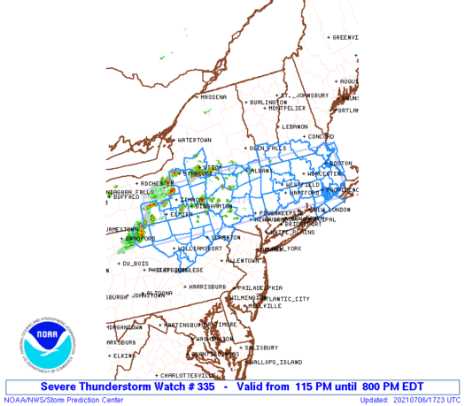
The Aviation Watch (SAW) product is an approximation to the watch area.
The actual watch is depicted by the shaded areas.
Note:
The Aviation Watch (SAW) product is an approximation to the watch area.
The actual watch is depicted by the shaded areas.
   SAW5
   WW 335 SEVERE TSTM CT MA NH NY PA RI VT CW 061715Z - 070000Z
   AXIS..50 STATUTE MILES NORTH AND SOUTH OF LINE..
   35W ELM/ELMIRA NY/ - 25SE BOS/BOSTON MA/
   ..AVIATION COORDS.. 45NM N/S /43NNE SLT - 21SE BOS/
   HAIL SURFACE AND ALOFT..1 INCH. WIND GUSTS..55 KNOTS.
   MAX TOPS TO 500. MEAN STORM MOTION VECTOR 31025.

   LAT...LON 42897758 42847066 41397066 41447758

   THIS IS AN APPROXIMATION TO THE WATCH AREA.  FOR A
   COMPLETE DEPICTION OF THE WATCH SEE WOUS64 KWNS
   FOR WOU5.
Watch 335 Status Report Messages:
STATUS REPORT #5 ON WW 335

VALID 062235Z - 062340Z

SEVERE WEATHER THREAT CONTINUES RIGHT OF A LINE FROM 30 SSW IPT
TO 30 WNW AVP TO 25 NNE AVP TO 15 WNW MSV TO 25 ENE MSV TO 25 E
POU TO 20 SSE BDL TO 20 SW BOS TO 25 E PSM.

FOR ADDITIONAL INFORMATION SEE MESOSCALE DISCUSSION 1164

..MOORE..07/06/21

ATTN...WFO...BOX...ALY...GYX...BGM...CTP...

&&

STATUS REPORT FOR WS 335

SEVERE WEATHER THREAT CONTINUES FOR THE FOLLOWING AREAS

CTC013-015-062340-

CT
.    CONNECTICUT COUNTIES INCLUDED ARE

TOLLAND 	     WINDHAM
$$


MAC005-021-023-025-062340-

MA
.    MASSACHUSETTS COUNTIES INCLUDED ARE

BRISTOL 	     NORFOLK		 PLYMOUTH
SUFFOLK
$$


NYC105-062340-

NY
.    NEW YORK COUNTIES INCLUDED ARE

SULLIVAN
$$


PAC037-069-079-093-097-103-127-131-062340-

PA
.    PENNSYLVANIA COUNTIES INCLUDED ARE

COLUMBIA	     LACKAWANNA 	 LUZERNE
MONTOUR 	     NORTHUMBERLAND	 PIKE
WAYNE		     WYOMING
$$


RIC001-003-005-007-009-062340-

RI
.    RHODE ISLAND COUNTIES INCLUDED ARE

BRISTOL 	     KENT		 NEWPORT
PROVIDENCE	     WASHINGTON
$$


ANZ230-235-236-237-251-062340-

CW

.    ADJACENT COASTAL WATERS INCLUDED ARE

BOSTON HARBOR

RHODE ISLAND SOUND

NARRAGANSETT BAY

BLOCK ISLAND SOUND

MASSACHUSETTS BAY AND IPSWICH BAY

$$
THE WATCH STATUS MESSAGE IS FOR GUIDANCE PURPOSES ONLY.  PLEASE
REFER TO WATCH COUNTY NOTIFICATION STATEMENTS FOR OFFICIAL
INFORMATION ON COUNTIES...INDEPENDENT CITIES AND MARINE ZONES
CLEARED FROM SEVERE THUNDERSTORM AND TORNADO WATCHES.
$$

STATUS REPORT #4 ON WW 335

VALID 062150Z - 062240Z

SEVERE WEATHER THREAT CONTINUES RIGHT OF A LINE FROM 40 N UNV TO
15 S BGM TO 50 WSW ALB TO 5 NNW ALB TO 20 S RUT TO 20 ESE PSM.

FOR ADDITIONAL INFORMATION SEE MESOSCALE DISCUSSION 1164

..MOORE..07/06/21

ATTN...WFO...BOX...ALY...GYX...BGM...CTP...

&&

STATUS REPORT FOR WS 335

SEVERE WEATHER THREAT CONTINUES FOR THE FOLLOWING AREAS

CTC003-005-013-015-062240-

CT
.    CONNECTICUT COUNTIES INCLUDED ARE

HARTFORD	     LITCHFIELD 	 TOLLAND
WINDHAM
$$


MAC003-005-009-011-013-015-017-021-023-025-027-062240-

MA
.    MASSACHUSETTS COUNTIES INCLUDED ARE

BERKSHIRE	     BRISTOL		 ESSEX
FRANKLIN	     HAMPDEN		 HAMPSHIRE
MIDDLESEX	     NORFOLK		 PLYMOUTH
SUFFOLK 	     WORCESTER
$$


NHC005-011-062240-

NH
.    NEW HAMPSHIRE COUNTIES INCLUDED ARE

CHESHIRE	     HILLSBOROUGH
$$


NYC001-021-025-027-039-083-095-105-111-062240-

NY
.    NEW YORK COUNTIES INCLUDED ARE

ALBANY		     COLUMBIA		 DELAWARE
DUTCHESS	     GREENE		 RENSSELAER
SCHOHARIE	     SULLIVAN		 ULSTER
$$


PAC037-069-079-081-093-097-103-113-115-127-131-062240-

PA
.    PENNSYLVANIA COUNTIES INCLUDED ARE

COLUMBIA	     LACKAWANNA 	 LUZERNE
LYCOMING	     MONTOUR		 NORTHUMBERLAND
PIKE		     SULLIVAN		 SUSQUEHANNA
WAYNE		     WYOMING
$$


RIC001-003-005-007-009-062240-

RI
.    RHODE ISLAND COUNTIES INCLUDED ARE

BRISTOL 	     KENT		 NEWPORT
PROVIDENCE	     WASHINGTON
$$


VTC003-025-062240-

VT
.    VERMONT COUNTIES INCLUDED ARE

BENNINGTON	     WINDHAM
$$


ANZ230-235-236-237-251-062240-

CW

.    ADJACENT COASTAL WATERS INCLUDED ARE

BOSTON HARBOR

RHODE ISLAND SOUND

NARRAGANSETT BAY

BLOCK ISLAND SOUND

MASSACHUSETTS BAY AND IPSWICH BAY

$$
THE WATCH STATUS MESSAGE IS FOR GUIDANCE PURPOSES ONLY.  PLEASE
REFER TO WATCH COUNTY NOTIFICATION STATEMENTS FOR OFFICIAL
INFORMATION ON COUNTIES...INDEPENDENT CITIES AND MARINE ZONES
CLEARED FROM SEVERE THUNDERSTORM AND TORNADO WATCHES.
$$

STATUS REPORT #3 ON WW 335

VALID 062040Z - 062140Z

SEVERE WEATHER THREAT CONTINUES RIGHT OF A LINE FROM 50 SW ELM TO
30 SE GFL.

..BUNTING..07/06/21

ATTN...WFO...BOX...ALY...GYX...BGM...CTP...

&&

STATUS REPORT FOR WS 335

SEVERE WEATHER THREAT CONTINUES FOR THE FOLLOWING AREAS

CTC003-005-013-015-062140-

CT
.    CONNECTICUT COUNTIES INCLUDED ARE

HARTFORD	     LITCHFIELD 	 TOLLAND
WINDHAM
$$


MAC003-005-009-011-013-015-017-021-023-025-027-062140-

MA
.    MASSACHUSETTS COUNTIES INCLUDED ARE

BERKSHIRE	     BRISTOL		 ESSEX
FRANKLIN	     HAMPDEN		 HAMPSHIRE
MIDDLESEX	     NORFOLK		 PLYMOUTH
SUFFOLK 	     WORCESTER
$$


NHC005-011-062140-

NH
.    NEW HAMPSHIRE COUNTIES INCLUDED ARE

CHESHIRE	     HILLSBOROUGH
$$


NYC001-021-025-027-039-083-095-105-111-062140-

NY
.    NEW YORK COUNTIES INCLUDED ARE

ALBANY		     COLUMBIA		 DELAWARE
DUTCHESS	     GREENE		 RENSSELAER
SCHOHARIE	     SULLIVAN		 ULSTER
$$


PAC037-069-079-081-093-097-103-113-115-127-131-062140-

PA
.    PENNSYLVANIA COUNTIES INCLUDED ARE

COLUMBIA	     LACKAWANNA 	 LUZERNE
LYCOMING	     MONTOUR		 NORTHUMBERLAND
PIKE		     SULLIVAN		 SUSQUEHANNA
WAYNE		     WYOMING
$$


RIC001-003-005-007-009-062140-

RI
.    RHODE ISLAND COUNTIES INCLUDED ARE

BRISTOL 	     KENT		 NEWPORT
PROVIDENCE	     WASHINGTON
$$


VTC003-025-062140-

VT
.    VERMONT COUNTIES INCLUDED ARE

BENNINGTON	     WINDHAM
$$


ANZ230-235-236-237-251-062140-

CW

.    ADJACENT COASTAL WATERS INCLUDED ARE

BOSTON HARBOR

RHODE ISLAND SOUND

NARRAGANSETT BAY

BLOCK ISLAND SOUND

MASSACHUSETTS BAY AND IPSWICH BAY

$$
THE WATCH STATUS MESSAGE IS FOR GUIDANCE PURPOSES ONLY.  PLEASE
REFER TO WATCH COUNTY NOTIFICATION STATEMENTS FOR OFFICIAL
INFORMATION ON COUNTIES...INDEPENDENT CITIES AND MARINE ZONES
CLEARED FROM SEVERE THUNDERSTORM AND TORNADO WATCHES.
$$

STATUS REPORT #2 ON WW 335

VALID 061940Z - 062040Z

SEVERE WEATHER THREAT CONTINUES RIGHT OF A LINE FROM 40 W ELM TO
25 SE UCA.

..BUNTING..07/06/21

ATTN...WFO...BOX...ALY...GYX...BGM...CTP...

&&

STATUS REPORT FOR WS 335

SEVERE WEATHER THREAT CONTINUES FOR THE FOLLOWING AREAS

CTC003-005-013-015-062040-

CT
.    CONNECTICUT COUNTIES INCLUDED ARE

HARTFORD	     LITCHFIELD 	 TOLLAND
WINDHAM
$$


MAC003-005-009-011-013-015-017-021-023-025-027-062040-

MA
.    MASSACHUSETTS COUNTIES INCLUDED ARE

BERKSHIRE	     BRISTOL		 ESSEX
FRANKLIN	     HAMPDEN		 HAMPSHIRE
MIDDLESEX	     NORFOLK		 PLYMOUTH
SUFFOLK 	     WORCESTER
$$


NHC005-011-062040-

NH
.    NEW HAMPSHIRE COUNTIES INCLUDED ARE

CHESHIRE	     HILLSBOROUGH
$$


NYC001-007-015-017-021-023-025-027-039-057-077-083-093-095-105-
107-111-062040-

NY
.    NEW YORK COUNTIES INCLUDED ARE

ALBANY		     BROOME		 CHEMUNG
CHENANGO	     COLUMBIA		 CORTLAND
DELAWARE	     DUTCHESS		 GREENE
MONTGOMERY	     OTSEGO		 RENSSELAER
SCHENECTADY	     SCHOHARIE		 SULLIVAN
TIOGA		     ULSTER
$$


PAC015-037-069-079-081-093-097-103-105-113-115-117-127-131-
062040-

PA
.    PENNSYLVANIA COUNTIES INCLUDED ARE

BRADFORD	     COLUMBIA		 LACKAWANNA
LUZERNE 	     LYCOMING		 MONTOUR
NORTHUMBERLAND	     PIKE		 POTTER
SULLIVAN	     SUSQUEHANNA	 TIOGA
WAYNE		     WYOMING
$$


RIC001-003-005-007-009-062040-

RI
.    RHODE ISLAND COUNTIES INCLUDED ARE

BRISTOL 	     KENT		 NEWPORT
PROVIDENCE	     WASHINGTON
$$


VTC003-025-062040-

VT
.    VERMONT COUNTIES INCLUDED ARE

BENNINGTON	     WINDHAM
$$


ANZ230-235-236-237-251-062040-

CW

.    ADJACENT COASTAL WATERS INCLUDED ARE

BOSTON HARBOR

RHODE ISLAND SOUND

NARRAGANSETT BAY

BLOCK ISLAND SOUND

MASSACHUSETTS BAY AND IPSWICH BAY

$$
THE WATCH STATUS MESSAGE IS FOR GUIDANCE PURPOSES ONLY.  PLEASE
REFER TO WATCH COUNTY NOTIFICATION STATEMENTS FOR OFFICIAL
INFORMATION ON COUNTIES...INDEPENDENT CITIES AND MARINE ZONES
CLEARED FROM SEVERE THUNDERSTORM AND TORNADO WATCHES.
$$

STATUS REPORT #1 ON WW 335

VALID 061830Z - 061940Z

THE SEVERE WEATHER THREAT CONTINUES ACROSS THE ENTIRE WATCH AREA.

..BUNTING..07/06/21

ATTN...WFO...BOX...ALY...GYX...BGM...CTP...

&&

STATUS REPORT FOR WS 335

SEVERE WEATHER THREAT CONTINUES FOR THE FOLLOWING AREAS

CTC003-005-013-015-061940-

CT
.    CONNECTICUT COUNTIES INCLUDED ARE

HARTFORD	     LITCHFIELD 	 TOLLAND
WINDHAM
$$


MAC003-005-009-011-013-015-017-021-023-025-027-061940-

MA
.    MASSACHUSETTS COUNTIES INCLUDED ARE

BERKSHIRE	     BRISTOL		 ESSEX
FRANKLIN	     HAMPDEN		 HAMPSHIRE
MIDDLESEX	     NORFOLK		 PLYMOUTH
SUFFOLK 	     WORCESTER
$$


NHC005-011-061940-

NH
.    NEW HAMPSHIRE COUNTIES INCLUDED ARE

CHESHIRE	     HILLSBOROUGH
$$


NYC001-007-015-017-021-023-025-027-039-053-057-065-067-077-083-
093-095-097-101-105-107-109-111-061940-

NY
.    NEW YORK COUNTIES INCLUDED ARE

ALBANY		     BROOME		 CHEMUNG
CHENANGO	     COLUMBIA		 CORTLAND
DELAWARE	     DUTCHESS		 GREENE
MADISON 	     MONTGOMERY 	 ONEIDA
ONONDAGA	     OTSEGO		 RENSSELAER
SCHENECTADY	     SCHOHARIE		 SCHUYLER
STEUBEN 	     SULLIVAN		 TIOGA
TOMPKINS	     ULSTER
$$


PAC015-037-069-079-081-093-097-103-105-113-115-117-127-131-
061940-

PA
.    PENNSYLVANIA COUNTIES INCLUDED ARE

BRADFORD	     COLUMBIA		 LACKAWANNA
LUZERNE 	     LYCOMING		 MONTOUR
NORTHUMBERLAND	     PIKE		 POTTER
SULLIVAN	     SUSQUEHANNA	 TIOGA
WAYNE		     WYOMING
$$


RIC001-003-005-007-009-061940-

RI
.    RHODE ISLAND COUNTIES INCLUDED ARE

BRISTOL 	     KENT		 NEWPORT
PROVIDENCE	     WASHINGTON
$$


VTC003-025-061940-

VT
.    VERMONT COUNTIES INCLUDED ARE

BENNINGTON	     WINDHAM
$$


ANZ230-235-236-237-251-061940-

CW

.    ADJACENT COASTAL WATERS INCLUDED ARE

BOSTON HARBOR

RHODE ISLAND SOUND

NARRAGANSETT BAY

BLOCK ISLAND SOUND

MASSACHUSETTS BAY AND IPSWICH BAY

$$
THE WATCH STATUS MESSAGE IS FOR GUIDANCE PURPOSES ONLY.  PLEASE
REFER TO WATCH COUNTY NOTIFICATION STATEMENTS FOR OFFICIAL
INFORMATION ON COUNTIES...INDEPENDENT CITIES AND MARINE ZONES
CLEARED FROM SEVERE THUNDERSTORM AND TORNADO WATCHES.
$$
Note:
Click for Complete Product Text.
Tornadoes
Probability of 2 or more tornadoes
|
Low (10%)
|
Probability of 1 or more strong (EF2-EF5) tornadoes
|
Low (5%)
|
Wind
Probability of 10 or more severe wind events
|
High (70%)
|
Probability of 1 or more wind events > 65 knots
|
Low (10%)
|
Hail
Probability of 10 or more severe hail events
|
Low (20%)
|
Probability of 1 or more hailstones > 2 inches
|
Low (<5%)
|
Combined Severe Hail/Wind
Probability of 6 or more combined severe hail/wind events
|
High (90%)
|
For each watch, probabilities for particular events inside the watch
(listed above in each table) are determined by the issuing forecaster.
The "Low" category contains probability values ranging from less than 2%
to 20% (EF2-EF5 tornadoes), less than 5% to 20% (all other probabilities),
"Moderate" from 30% to 60%, and "High" from 70% to greater than 95%.
High values are bolded and lighter in color to provide awareness of
an increased threat for a particular event.


 @NWSSPC