Note:
The expiration time in the watch graphic is amended if the watch is
replaced, cancelled or extended.
Note:
Note:
The expiration time in the watch graphic is amended if the watch is
replaced, cancelled or extended.
Note: Click for
Watch Status Reports.
SEL4
URGENT - IMMEDIATE BROADCAST REQUESTED
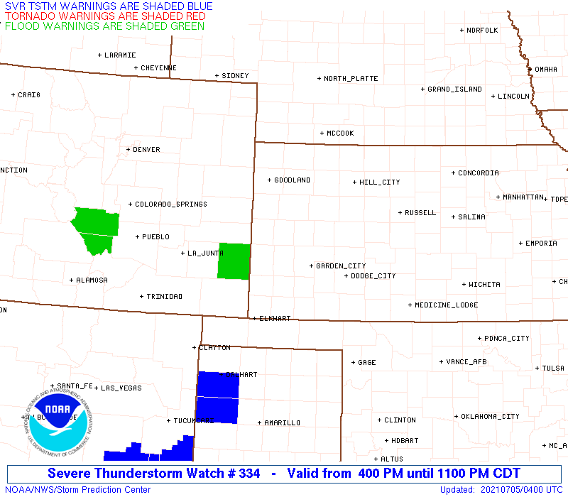
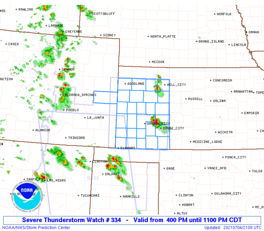
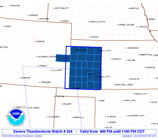
Severe Thunderstorm Watch Number 334
NWS Storm Prediction Center Norman OK
400 PM CDT Sun Jul 4 2021
The NWS Storm Prediction Center has issued a
* Severe Thunderstorm Watch for portions of
Eastern Colorado
Western Kansas
* Effective this Sunday afternoon and evening from 400 PM until
1100 PM CDT.
* Primary threats include...
Scattered large hail and isolated very large hail events to 2
inches in diameter possible
Scattered damaging wind gusts to 70 mph possible
SUMMARY...Storms are expected to continue to develop and intensify
across west-central Kansas through late afternoon/early evening,
with subsequent development possible farther west across
west/southwest Kansas and possibly nearby eastern Colorado this
evening. Modest-strength winds and an unstable air mass will support
the potential for large hail and damaging winds.
The severe thunderstorm watch area is approximately along and 75
statute miles east and west of a line from 40 miles east northeast
of Goodland KS to 5 miles south southwest of Liberal KS. For a
complete depiction of the watch see the associated watch outline
update (WOUS64 KWNS WOU4).
PRECAUTIONARY/PREPAREDNESS ACTIONS...
REMEMBER...A Severe Thunderstorm Watch means conditions are
favorable for severe thunderstorms in and close to the watch area.
Persons in these areas should be on the lookout for threatening
weather conditions and listen for later statements and possible
warnings. Severe thunderstorms can and occasionally do produce
tornadoes.
&&
OTHER WATCH INFORMATION...CONTINUE...WW 333...
AVIATION...A few severe thunderstorms with hail surface and aloft to
2 inches. Extreme turbulence and surface wind gusts to 60 knots. A
few cumulonimbi with maximum tops to 550. Mean storm motion vector
35015.
...Guyer
   SEL4

   URGENT - IMMEDIATE BROADCAST REQUESTED
   Severe Thunderstorm Watch Number 334
   NWS Storm Prediction Center Norman OK
   400 PM CDT Sun Jul 4 2021

   The NWS Storm Prediction Center has issued a

   * Severe Thunderstorm Watch for portions of
     Eastern Colorado
     Western Kansas

   * Effective this Sunday afternoon and evening from 400 PM until
     1100 PM CDT.

   * Primary threats include...
     Scattered large hail and isolated very large hail events to 2
       inches in diameter possible
     Scattered damaging wind gusts to 70 mph possible

   SUMMARY...Storms are expected to continue to develop and intensify
   across west-central Kansas through late afternoon/early evening,
   with subsequent development possible farther west across
   west/southwest Kansas and possibly nearby eastern Colorado this
   evening. Modest-strength winds and an unstable air mass will support
   the potential for large hail and damaging winds.

   The severe thunderstorm watch area is approximately along and 75
   statute miles east and west of a line from 40 miles east northeast
   of Goodland KS to 5 miles south southwest of Liberal KS. For a
   complete depiction of the watch see the associated watch outline
   update (WOUS64 KWNS WOU4).

   PRECAUTIONARY/PREPAREDNESS ACTIONS...

   REMEMBER...A Severe Thunderstorm Watch means conditions are
   favorable for severe thunderstorms in and close to the watch area.
   Persons in these areas should be on the lookout for threatening
   weather conditions and listen for later statements and possible
   warnings. Severe thunderstorms can and occasionally do produce
   tornadoes.

   &&

   OTHER WATCH INFORMATION...CONTINUE...WW 333...

   AVIATION...A few severe thunderstorms with hail surface and aloft to
   2 inches. Extreme turbulence and surface wind gusts to 60 knots. A
   few cumulonimbi with maximum tops to 550. Mean storm motion vector
   35015.

   ...Guyer
 Note:
The Aviation Watch (SAW) product is an approximation to the watch area.
The actual watch is depicted by the shaded areas.
Note:
The Aviation Watch (SAW) product is an approximation to the watch area.
The actual watch is depicted by the shaded areas.
   SAW4
   WW 334 SEVERE TSTM CO KS 042100Z - 050400Z
   AXIS..75 STATUTE MILES EAST AND WEST OF LINE..
   40ENE GLD/GOODLAND KS/ - 5SSW LBL/LIBERAL KS/
   ..AVIATION COORDS.. 65NM E/W /34ENE GLD - 4SSW LBL/
   HAIL SURFACE AND ALOFT..2 INCHES. WIND GUSTS..60 KNOTS.
   MAX TOPS TO 550. MEAN STORM MOTION VECTOR 35015.

   LAT...LON 39579960 36979965 36970236 39570241

   THIS IS AN APPROXIMATION TO THE WATCH AREA.  FOR A
   COMPLETE DEPICTION OF THE WATCH SEE WOUS64 KWNS
   FOR WOU4.
Watch 334 Status Report Messages:
STATUS REPORT #4 ON WW 334

VALID 050225Z - 050400Z

SEVERE WEATHER THREAT CONTINUES RIGHT OF A LINE FROM 20 NW GLD TO
45 SSE ITR TO 50 ENE LAA TO 20 N GUY.

A NEW WW IS NOT ANTICIPATED, BUT PARTS OF REMAINING VALID PORTION
OF WW COULD BE LOCALLY EXTENDED IN TIME FOR AN HOUR OR SO.

..KERR..07/05/21

ATTN...WFO...GLD...DDC...

&&

STATUS REPORT FOR WS 334

SEVERE WEATHER THREAT CONTINUES FOR THE FOLLOWING AREAS

COC017-050400-

CO
.    COLORADO COUNTIES INCLUDED ARE

CHEYENNE
$$


KSC071-075-129-187-050400-

KS
.    KANSAS COUNTIES INCLUDED ARE

GREELEY 	     HAMILTON		 MORTON
STANTON
$$


THE WATCH STATUS MESSAGE IS FOR GUIDANCE PURPOSES ONLY.  PLEASE
REFER TO WATCH COUNTY NOTIFICATION STATEMENTS FOR OFFICIAL
INFORMATION ON COUNTIES...INDEPENDENT CITIES AND MARINE ZONES
CLEARED FROM SEVERE THUNDERSTORM AND TORNADO WATCHES.
$$

STATUS REPORT #3 ON WW 334

VALID 050130Z - 050240Z

SEVERE WEATHER THREAT CONTINUES RIGHT OF A LINE FROM 15 N GLD TO
45 SSE GLD TO 40 WNW GCK TO 15 WSW LBL.

..KERR..07/05/21

ATTN...WFO...GLD...DDC...

&&

STATUS REPORT FOR WS 334

SEVERE WEATHER THREAT CONTINUES FOR THE FOLLOWING AREAS

COC017-050240-

CO
.    COLORADO COUNTIES INCLUDED ARE

CHEYENNE
$$


KSC067-071-075-093-129-181-187-189-199-050240-

KS
.    KANSAS COUNTIES INCLUDED ARE

GRANT		     GREELEY		 HAMILTON
KEARNY		     MORTON		 SHERMAN
STANTON 	     STEVENS		 WALLACE
$$


THE WATCH STATUS MESSAGE IS FOR GUIDANCE PURPOSES ONLY.  PLEASE
REFER TO WATCH COUNTY NOTIFICATION STATEMENTS FOR OFFICIAL
INFORMATION ON COUNTIES...INDEPENDENT CITIES AND MARINE ZONES
CLEARED FROM SEVERE THUNDERSTORM AND TORNADO WATCHES.
$$

STATUS REPORT #2 ON WW 334

VALID 050035Z - 050140Z

SEVERE WEATHER THREAT CONTINUES RIGHT OF A LINE FROM 40 ENE GLD
TO 5 SW LBL.

..KERR..07/05/21

ATTN...WFO...GLD...DDC...

&&

STATUS REPORT FOR WS 334

SEVERE WEATHER THREAT CONTINUES FOR THE FOLLOWING AREAS

COC017-050140-

CO
.    COLORADO COUNTIES INCLUDED ARE

CHEYENNE
$$


KSC067-071-075-093-109-129-181-187-189-199-203-050140-

KS
.    KANSAS COUNTIES INCLUDED ARE

GRANT		     GREELEY		 HAMILTON
KEARNY		     LOGAN		 MORTON
SHERMAN 	     STANTON		 STEVENS
WALLACE 	     WICHITA
$$


THE WATCH STATUS MESSAGE IS FOR GUIDANCE PURPOSES ONLY.  PLEASE
REFER TO WATCH COUNTY NOTIFICATION STATEMENTS FOR OFFICIAL
INFORMATION ON COUNTIES...INDEPENDENT CITIES AND MARINE ZONES
CLEARED FROM SEVERE THUNDERSTORM AND TORNADO WATCHES.
$$

STATUS REPORT #1 ON WW 334

VALID 042235Z - 042340Z

THE SEVERE WEATHER THREAT CONTINUES ACROSS THE ENTIRE WATCH AREA.

..KERR..07/04/21

ATTN...WFO...GLD...DDC...

&&

STATUS REPORT FOR WS 334

SEVERE WEATHER THREAT CONTINUES FOR THE FOLLOWING AREAS

COC017-042340-

CO
.    COLORADO COUNTIES INCLUDED ARE

CHEYENNE
$$


KSC025-055-057-063-065-067-069-071-075-081-083-093-101-109-119-
129-135-171-175-179-181-187-189-193-195-199-203-042340-

KS
.    KANSAS COUNTIES INCLUDED ARE

CLARK		     FINNEY		 FORD
GOVE		     GRAHAM		 GRANT
GRAY		     GREELEY		 HAMILTON
HASKELL 	     HODGEMAN		 KEARNY
LANE		     LOGAN		 MEADE
MORTON		     NESS		 SCOTT
SEWARD		     SHERIDAN		 SHERMAN
STANTON 	     STEVENS		 THOMAS
TREGO		     WALLACE		 WICHITA
$$


THE WATCH STATUS MESSAGE IS FOR GUIDANCE PURPOSES ONLY.  PLEASE
REFER TO WATCH COUNTY NOTIFICATION STATEMENTS FOR OFFICIAL
INFORMATION ON COUNTIES...INDEPENDENT CITIES AND MARINE ZONES
CLEARED FROM SEVERE THUNDERSTORM AND TORNADO WATCHES.
$$
Note:
Click for Complete Product Text.
Tornadoes
Probability of 2 or more tornadoes
|
Low (10%)
|
Probability of 1 or more strong (EF2-EF5) tornadoes
|
Low (5%)
|
Wind
Probability of 10 or more severe wind events
|
Mod (40%)
|
Probability of 1 or more wind events > 65 knots
|
Low (20%)
|
Hail
Probability of 10 or more severe hail events
|
Mod (50%)
|
Probability of 1 or more hailstones > 2 inches
|
Mod (40%)
|
Combined Severe Hail/Wind
Probability of 6 or more combined severe hail/wind events
|
High (80%)
|
For each watch, probabilities for particular events inside the watch
(listed above in each table) are determined by the issuing forecaster.
The "Low" category contains probability values ranging from less than 2%
to 20% (EF2-EF5 tornadoes), less than 5% to 20% (all other probabilities),
"Moderate" from 30% to 60%, and "High" from 70% to greater than 95%.
High values are bolded and lighter in color to provide awareness of
an increased threat for a particular event.


 @NWSSPC