Note:
The expiration time in the watch graphic is amended if the watch is
replaced, cancelled or extended.
Note:
Note:
The expiration time in the watch graphic is amended if the watch is
replaced, cancelled or extended.
Note: Click for
Watch Status Reports.
SEL3
URGENT - IMMEDIATE BROADCAST REQUESTED
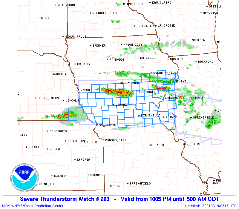
Severe Thunderstorm Watch Number 283
NWS Storm Prediction Center Norman OK
1005 PM CDT Fri Jun 18 2021
The NWS Storm Prediction Center has issued a
* Severe Thunderstorm Watch for portions of
Southern and Eastern Iowa
Western Illinois
Northern Missouri
Southeast Nebraska
* Effective this Friday night and Saturday morning from 1005 PM
until 500 AM CDT.
* Primary threats include...
Scattered large hail likely with isolated very large hail events
to 2.5 inches in diameter possible
Scattered damaging wind gusts to 70 mph possible
A tornado or two possible
SUMMARY...Multiple corridors of strong to severe storm development
are expected late this evening including across southern Iowa as
well as southeast Nebraska into northern Missouri. The strongest
storms will be capable of large hail. Damaging winds will also be a
possibility, particularly if a well-organized linear cluster evolves
through the early overnight hours as storms spread
east-southeastward across the region.
The severe thunderstorm watch area is approximately along and 65
statute miles north and south of a line from 25 miles west of
Shenandoah IA to 30 miles east southeast of Burlington IA. For a
complete depiction of the watch see the associated watch outline
update (WOUS64 KWNS WOU3).
PRECAUTIONARY/PREPAREDNESS ACTIONS...
REMEMBER...A Severe Thunderstorm Watch means conditions are
favorable for severe thunderstorms in and close to the watch area.
Persons in these areas should be on the lookout for threatening
weather conditions and listen for later statements and possible
warnings. Severe thunderstorms can and occasionally do produce
tornadoes.
&&
OTHER WATCH INFORMATION...CONTINUE...WW 280...WW 281...WW 282...
AVIATION...A few severe thunderstorms with hail surface and aloft to
2.5 inches. Extreme turbulence and surface wind gusts to 60 knots. A
few cumulonimbi with maximum tops to 600. Mean storm motion vector
29025.
...Guyer

   SEL3

   URGENT - IMMEDIATE BROADCAST REQUESTED
   Severe Thunderstorm Watch Number 283
   NWS Storm Prediction Center Norman OK
   1005 PM CDT Fri Jun 18 2021

   The NWS Storm Prediction Center has issued a

   * Severe Thunderstorm Watch for portions of
     Southern and Eastern Iowa
     Western Illinois
     Northern Missouri
     Southeast Nebraska

   * Effective this Friday night and Saturday morning from 1005 PM
     until 500 AM CDT.

   * Primary threats include...
     Scattered large hail likely with isolated very large hail events
       to 2.5 inches in diameter possible
     Scattered damaging wind gusts to 70 mph possible
     A tornado or two possible

   SUMMARY...Multiple corridors of strong to severe storm development
   are expected late this evening including across southern Iowa as
   well as southeast Nebraska into northern Missouri. The strongest
   storms will be capable of large hail. Damaging winds will also be a
   possibility, particularly if a well-organized linear cluster evolves
   through the early overnight hours as storms spread
   east-southeastward across the region.

   The severe thunderstorm watch area is approximately along and 65
   statute miles north and south of a line from 25 miles west of
   Shenandoah IA to 30 miles east southeast of Burlington IA. For a
   complete depiction of the watch see the associated watch outline
   update (WOUS64 KWNS WOU3).

   PRECAUTIONARY/PREPAREDNESS ACTIONS...

   REMEMBER...A Severe Thunderstorm Watch means conditions are
   favorable for severe thunderstorms in and close to the watch area.
   Persons in these areas should be on the lookout for threatening
   weather conditions and listen for later statements and possible
   warnings. Severe thunderstorms can and occasionally do produce
   tornadoes.

   &&

   OTHER WATCH INFORMATION...CONTINUE...WW 280...WW 281...WW 282...

   AVIATION...A few severe thunderstorms with hail surface and aloft to
   2.5 inches. Extreme turbulence and surface wind gusts to 60 knots. A
   few cumulonimbi with maximum tops to 600. Mean storm motion vector
   29025.

   ...Guyer
 Note:
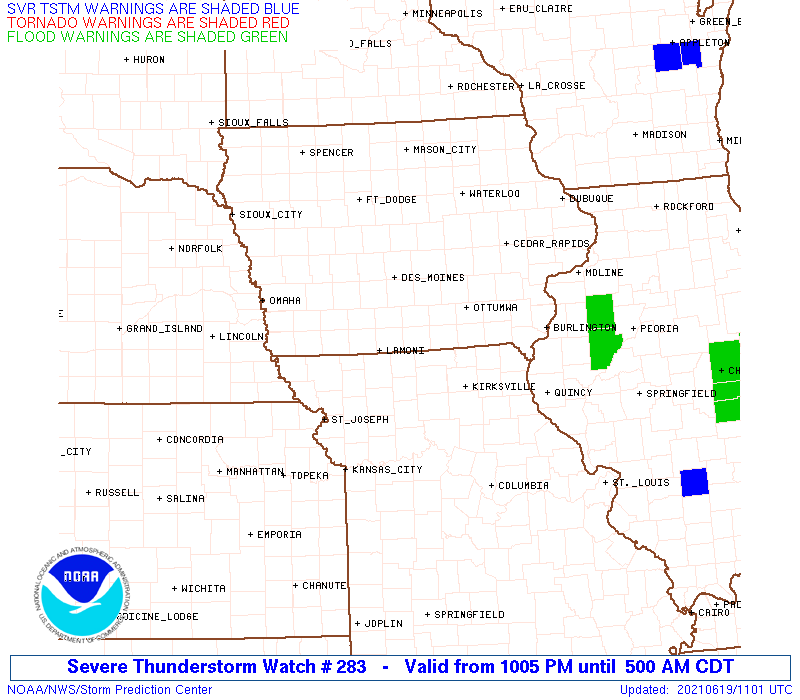
The Aviation Watch (SAW) product is an approximation to the watch area.
The actual watch is depicted by the shaded areas.
Note:
The Aviation Watch (SAW) product is an approximation to the watch area.
The actual watch is depicted by the shaded areas.
SAW3
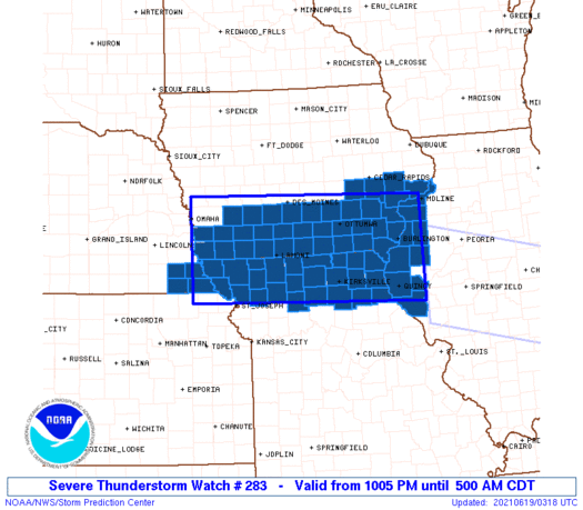
WW 283 SEVERE TSTM IA IL MO NE 190305Z - 191000Z
AXIS..65 STATUTE MILES NORTH AND SOUTH OF LINE..
25W SDA/SHENANDOAH IA/ - 30ESE BRL/BURLINGTON IA/
..AVIATION COORDS.. 55NM N/S /26SSW OVR - 55NE UIN/
HAIL SURFACE AND ALOFT..2.5 INCHES. WIND GUSTS..60 KNOTS.
MAX TOPS TO 600. MEAN STORM MOTION VECTOR 29025.
LAT...LON 41699590 41559060 39669060 39819590
THIS IS AN APPROXIMATION TO THE WATCH AREA. FOR A
COMPLETE DEPICTION OF THE WATCH SEE WOUS64 KWNS
FOR WOU3.
Watch 283 Status Report Messages:
STATUS REPORT #3 ON WW 283

VALID 190630Z - 190740Z

SEVERE WEATHER THREAT CONTINUES RIGHT OF A LINE FROM 20 S FNB TO
10 SSE OMA TO 45 ESE DNS.

..BROYLES..06/19/21

ATTN...WFO...DMX...DVN...OAX...LSX...EAX...

&&

STATUS REPORT FOR WS 283

SEVERE WEATHER THREAT CONTINUES FOR THE FOLLOWING AREAS

ILC001-009-011-067-071-073-109-131-149-155-161-187-190740-

IL
.    ILLINOIS COUNTIES INCLUDED ARE

ADAMS		     BROWN		 BUREAU
HANCOCK 	     HENDERSON		 HENRY
MCDONOUGH	     MERCER		 PIKE
PUTNAM		     ROCK ISLAND	 WARREN
$$


IAC001-003-007-029-031-039-051-053-057-071-087-095-101-103-107-
111-115-117-121-123-125-129-135-137-139-145-159-163-173-175-177-
179-181-183-185-190740-

IA
.    IOWA COUNTIES INCLUDED ARE

ADAIR		     ADAMS		 APPANOOSE
CASS		     CEDAR		 CLARKE
DAVIS		     DECATUR		 DES MOINES
FREMONT 	     HENRY		 IOWA
JEFFERSON	     JOHNSON		 KEOKUK
LEE		     LOUISA		 LUCAS
MADISON 	     MAHASKA		 MARION
MILLS		     MONROE		 MONTGOMERY
MUSCATINE	     PAGE		 RINGGOLD
SCOTT		     TAYLOR		 UNION
VAN BUREN	     WAPELLO		 WARREN
WASHINGTON	     WAYNE
$$


MOC001-003-005-045-061-063-075-079-081-087-103-111-115-117-121-
127-129-147-171-197-199-205-211-227-190740-

MO
.    MISSOURI COUNTIES INCLUDED ARE

ADAIR		     ANDREW		 ATCHISON
CLARK		     DAVIESS		 DEKALB
GENTRY		     GRUNDY		 HARRISON
HOLT		     KNOX		 LEWIS
LINN		     LIVINGSTON 	 MACON
MARION		     MERCER		 NODAWAY
PUTNAM		     SCHUYLER		 SCOTLAND
SHELBY		     SULLIVAN		 WORTH
$$


THE WATCH STATUS MESSAGE IS FOR GUIDANCE PURPOSES ONLY.  PLEASE
REFER TO WATCH COUNTY NOTIFICATION STATEMENTS FOR OFFICIAL
INFORMATION ON COUNTIES...INDEPENDENT CITIES AND MARINE ZONES
CLEARED FROM SEVERE THUNDERSTORM AND TORNADO WATCHES.
$$

STATUS REPORT #2 ON WW 283

VALID 190530Z - 190640Z

THE SEVERE WEATHER THREAT CONTINUES ACROSS THE ENTIRE WATCH AREA.

..BROYLES..06/19/21

ATTN...WFO...DMX...DVN...OAX...LSX...EAX...

&&

STATUS REPORT FOR WS 283

SEVERE WEATHER THREAT CONTINUES FOR THE FOLLOWING AREAS

ILC001-009-011-067-071-073-109-131-149-155-161-187-190640-

IL
.    ILLINOIS COUNTIES INCLUDED ARE

ADAMS		     BROWN		 BUREAU
HANCOCK 	     HENDERSON		 HENRY
MCDONOUGH	     MERCER		 PIKE
PUTNAM		     ROCK ISLAND	 WARREN
$$


IAC001-003-007-029-031-039-051-053-057-071-087-095-101-103-107-
111-115-117-121-123-125-129-135-137-139-145-159-163-173-175-177-
179-181-183-185-190640-

IA
.    IOWA COUNTIES INCLUDED ARE

ADAIR		     ADAMS		 APPANOOSE
CASS		     CEDAR		 CLARKE
DAVIS		     DECATUR		 DES MOINES
FREMONT 	     HENRY		 IOWA
JEFFERSON	     JOHNSON		 KEOKUK
LEE		     LOUISA		 LUCAS
MADISON 	     MAHASKA		 MARION
MILLS		     MONROE		 MONTGOMERY
MUSCATINE	     PAGE		 RINGGOLD
SCOTT		     TAYLOR		 UNION
VAN BUREN	     WAPELLO		 WARREN
WASHINGTON	     WAYNE
$$


MOC001-003-005-045-061-063-075-079-081-087-103-111-115-117-121-
127-129-147-171-197-199-205-211-227-190640-

MO
.    MISSOURI COUNTIES INCLUDED ARE

ADAIR		     ANDREW		 ATCHISON
CLARK		     DAVIESS		 DEKALB
GENTRY		     GRUNDY		 HARRISON
HOLT		     KNOX		 LEWIS
LINN		     LIVINGSTON 	 MACON
MARION		     MERCER		 NODAWAY
PUTNAM		     SCHUYLER		 SCOTLAND
SHELBY		     SULLIVAN		 WORTH
$$


THE WATCH STATUS MESSAGE IS FOR GUIDANCE PURPOSES ONLY.  PLEASE
REFER TO WATCH COUNTY NOTIFICATION STATEMENTS FOR OFFICIAL
INFORMATION ON COUNTIES...INDEPENDENT CITIES AND MARINE ZONES
CLEARED FROM SEVERE THUNDERSTORM AND TORNADO WATCHES.
$$

STATUS REPORT #1 ON WW 283

VALID 190420Z - 190540Z

THE SEVERE WEATHER THREAT CONTINUES ACROSS THE ENTIRE WATCH AREA.

..BUNTING..06/19/21

ATTN...WFO...DMX...DVN...OAX...LSX...EAX...

&&

STATUS REPORT FOR WS 283

SEVERE WEATHER THREAT CONTINUES FOR THE FOLLOWING AREAS

ILC001-009-011-067-071-073-109-131-149-155-161-187-190540-

IL
.    ILLINOIS COUNTIES INCLUDED ARE

ADAMS		     BROWN		 BUREAU
HANCOCK 	     HENDERSON		 HENRY
MCDONOUGH	     MERCER		 PIKE
PUTNAM		     ROCK ISLAND	 WARREN
$$


IAC001-003-007-029-031-039-051-053-057-071-087-095-101-103-107-
111-115-117-121-123-125-129-135-137-139-145-159-163-173-175-177-
179-181-183-185-190540-

IA
.    IOWA COUNTIES INCLUDED ARE

ADAIR		     ADAMS		 APPANOOSE
CASS		     CEDAR		 CLARKE
DAVIS		     DECATUR		 DES MOINES
FREMONT 	     HENRY		 IOWA
JEFFERSON	     JOHNSON		 KEOKUK
LEE		     LOUISA		 LUCAS
MADISON 	     MAHASKA		 MARION
MILLS		     MONROE		 MONTGOMERY
MUSCATINE	     PAGE		 RINGGOLD
SCOTT		     TAYLOR		 UNION
VAN BUREN	     WAPELLO		 WARREN
WASHINGTON	     WAYNE
$$


MOC001-003-005-045-061-063-075-079-081-087-103-111-115-117-121-
127-129-147-171-197-199-205-211-227-190540-

MO
.    MISSOURI COUNTIES INCLUDED ARE

ADAIR		     ANDREW		 ATCHISON
CLARK		     DAVIESS		 DEKALB
GENTRY		     GRUNDY		 HARRISON
HOLT		     KNOX		 LEWIS
LINN		     LIVINGSTON 	 MACON
MARION		     MERCER		 NODAWAY
PUTNAM		     SCHUYLER		 SCOTLAND
SHELBY		     SULLIVAN		 WORTH
$$


NEC097-127-133-147-190540-

NE
.    NEBRASKA COUNTIES INCLUDED ARE

JOHNSON 	     NEMAHA		 PAWNEE
RICHARDSON
$$


THE WATCH STATUS MESSAGE IS FOR GUIDANCE PURPOSES ONLY.  PLEASE
REFER TO WATCH COUNTY NOTIFICATION STATEMENTS FOR OFFICIAL
INFORMATION ON COUNTIES...INDEPENDENT CITIES AND MARINE ZONES
CLEARED FROM SEVERE THUNDERSTORM AND TORNADO WATCHES.
$$
Note:
Click for Complete Product Text.
Tornadoes
Probability of 2 or more tornadoes
|
Low (20%)
|
Probability of 1 or more strong (EF2-EF5) tornadoes
|
Low (<2%)
|
Wind
Probability of 10 or more severe wind events
|
Mod (50%)
|
Probability of 1 or more wind events > 65 knots
|
Low (10%)
|
Hail
Probability of 10 or more severe hail events
|
High (70%)
|
Probability of 1 or more hailstones > 2 inches
|
Mod (40%)
|
Combined Severe Hail/Wind
Probability of 6 or more combined severe hail/wind events
|
High (>95%)
|
For each watch, probabilities for particular events inside the watch
(listed above in each table) are determined by the issuing forecaster.
The "Low" category contains probability values ranging from less than 2%
to 20% (EF2-EF5 tornadoes), less than 5% to 20% (all other probabilities),
"Moderate" from 30% to 60%, and "High" from 70% to greater than 95%.
High values are bolded and lighter in color to provide awareness of
an increased threat for a particular event.


 @NWSSPC