 Note:
The expiration time in the watch graphic is amended if the watch is
replaced, cancelled or extended.
Note:
Note:
The expiration time in the watch graphic is amended if the watch is
replaced, cancelled or extended.
Note: Click for
Watch Status Reports.
SEL1
URGENT - IMMEDIATE BROADCAST REQUESTED
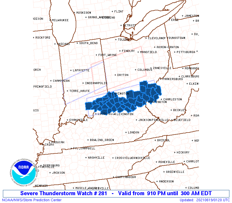
Severe Thunderstorm Watch Number 281
NWS Storm Prediction Center Norman OK
910 PM EDT Fri Jun 18 2021
The NWS Storm Prediction Center has issued a
* Severe Thunderstorm Watch for portions of
Southeast Indiana
Northern Kentucky
Southern Ohio
Western West Virginia
* Effective this Friday night and Saturday morning from 910 PM
until 300 AM EDT.
* Primary threats include...
Scattered damaging wind gusts to 70 mph possible
Isolated large hail events to 1.5 inches in diameter possible
A tornado or two possible
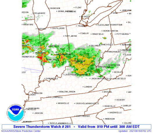
SUMMARY...Clusters of storms will continue to move
south-southeastward across the region this evening, and possibly
into the overnight, with damaging winds and some severe hail as the
primary hazards.
The severe thunderstorm watch area is approximately along and 30
statute miles north and south of a line from 35 miles northwest of
Louisville KY to 30 miles southeast of Athens OH. For a complete
depiction of the watch see the associated watch outline update
(WOUS64 KWNS WOU1).
PRECAUTIONARY/PREPAREDNESS ACTIONS...
REMEMBER...A Severe Thunderstorm Watch means conditions are
favorable for severe thunderstorms in and close to the watch area.
Persons in these areas should be on the lookout for threatening
weather conditions and listen for later statements and possible
warnings. Severe thunderstorms can and occasionally do produce
tornadoes.
&&
OTHER WATCH INFORMATION...CONTINUE...WW 279...WW 280...
AVIATION...A few severe thunderstorms with hail surface and aloft to
1.5 inches. Extreme turbulence and surface wind gusts to 60 knots. A
few cumulonimbi with maximum tops to 600. Mean storm motion vector
30035.
...Guyer

   SEL1

   URGENT - IMMEDIATE BROADCAST REQUESTED
   Severe Thunderstorm Watch Number 281
   NWS Storm Prediction Center Norman OK
   910 PM EDT Fri Jun 18 2021

   The NWS Storm Prediction Center has issued a

   * Severe Thunderstorm Watch for portions of
     Southeast Indiana
     Northern Kentucky
     Southern Ohio
     Western West Virginia

   * Effective this Friday night and Saturday morning from 910 PM
     until 300 AM EDT.

   * Primary threats include...
     Scattered damaging wind gusts to 70 mph possible
     Isolated large hail events to 1.5 inches in diameter possible
     A tornado or two possible

   SUMMARY...Clusters of storms will continue to move
   south-southeastward across the region this evening, and possibly
   into the overnight, with damaging winds and some severe hail as the
   primary hazards.

   The severe thunderstorm watch area is approximately along and 30
   statute miles north and south of a line from 35 miles northwest of
   Louisville KY to 30 miles southeast of Athens OH. For a complete
   depiction of the watch see the associated watch outline update
   (WOUS64 KWNS WOU1).

   PRECAUTIONARY/PREPAREDNESS ACTIONS...

   REMEMBER...A Severe Thunderstorm Watch means conditions are
   favorable for severe thunderstorms in and close to the watch area.
   Persons in these areas should be on the lookout for threatening
   weather conditions and listen for later statements and possible
   warnings. Severe thunderstorms can and occasionally do produce
   tornadoes.

   &&

   OTHER WATCH INFORMATION...CONTINUE...WW 279...WW 280...

   AVIATION...A few severe thunderstorms with hail surface and aloft to
   1.5 inches. Extreme turbulence and surface wind gusts to 60 knots. A
   few cumulonimbi with maximum tops to 600. Mean storm motion vector
   30035.

   ...Guyer
 Note:
The Aviation Watch (SAW) product is an approximation to the watch area.
The actual watch is depicted by the shaded areas.
Note:
The Aviation Watch (SAW) product is an approximation to the watch area.
The actual watch is depicted by the shaded areas.
   SAW1
   WW 281 SEVERE TSTM IN KY OH WV 190110Z - 190700Z
   AXIS..30 STATUTE MILES NORTH AND SOUTH OF LINE..
   35NW SDF/LOUISVILLE KY/ - 30SE UNI/ATHENS OH/
   ..AVIATION COORDS.. 25NM N/S /39NW IIU - 13NE HNN/
   HAIL SURFACE AND ALOFT..1.5 INCHES. WIND GUSTS..60 KNOTS.
   MAX TOPS TO 600. MEAN STORM MOTION VECTOR 30035.

   LAT...LON 38978619 39348183 38488183 38098619

   THIS IS AN APPROXIMATION TO THE WATCH AREA.  FOR A
   COMPLETE DEPICTION OF THE WATCH SEE WOUS64 KWNS
   FOR WOU1.
Watch 281 Status Report Messages:
STATUS REPORT #5 ON WW 281

VALID 190630Z - 190740Z

THE SEVERE WEATHER THREAT CONTINUES ACROSS THE ENTIRE WATCH AREA.

..BROYLES..06/19/21

ATTN...WFO...LMK...ILN...JKL...RLX...

&&

STATUS REPORT FOR WS 281

SEVERE WEATHER THREAT CONTINUES FOR THE FOLLOWING AREAS

INC019-029-047-077-115-137-143-155-175-190740-

IN
.    INDIANA COUNTIES INCLUDED ARE

CLARK		     DEARBORN		 FRANKLIN
JEFFERSON	     OHIO		 RIPLEY
SCOTT		     SWITZERLAND	 WASHINGTON
$$


KYC015-017-019-023-037-041-043-073-077-081-089-097-103-117-135-
161-181-185-187-191-201-209-211-223-190740-

KY
.    KENTUCKY COUNTIES INCLUDED ARE

BOONE		     BOURBON		 BOYD
BRACKEN 	     CAMPBELL		 CARROLL
CARTER		     FRANKLIN		 GALLATIN
GRANT		     GREENUP		 HARRISON
HENRY		     KENTON		 LEWIS
MASON		     NICHOLAS		 OLDHAM
OWEN		     PENDLETON		 ROBERTSON
SCOTT		     SHELBY		 TRIMBLE
$$


OHC001-015-017-025-027-053-061-071-079-087-105-131-141-145-163-
165-190740-

OH
.    OHIO COUNTIES INCLUDED ARE

ADAMS		     BROWN		 BUTLER
CLERMONT	     CLINTON		 GALLIA
HAMILTON	     HIGHLAND		 JACKSON
LAWRENCE	     MEIGS		 PIKE
ROSS		     SCIOTO		 VINTON
WARREN
$$


WVC011-035-053-079-190740-

WV
.    WEST VIRGINIA COUNTIES INCLUDED ARE

CABELL		     JACKSON		 MASON
PUTNAM
$$


THE WATCH STATUS MESSAGE IS FOR GUIDANCE PURPOSES ONLY.  PLEASE
REFER TO WATCH COUNTY NOTIFICATION STATEMENTS FOR OFFICIAL
INFORMATION ON COUNTIES...INDEPENDENT CITIES AND MARINE ZONES
CLEARED FROM SEVERE THUNDERSTORM AND TORNADO WATCHES.
$$

STATUS REPORT #4 ON WW 281

VALID 190530Z - 190640Z

THE SEVERE WEATHER THREAT CONTINUES ACROSS THE ENTIRE WATCH AREA.

..BROYLES..06/19/21

ATTN...WFO...LMK...ILN...JKL...RLX...

&&

STATUS REPORT FOR WS 281

SEVERE WEATHER THREAT CONTINUES FOR THE FOLLOWING AREAS

INC019-029-047-077-115-137-143-155-175-190640-

IN
.    INDIANA COUNTIES INCLUDED ARE

CLARK		     DEARBORN		 FRANKLIN
JEFFERSON	     OHIO		 RIPLEY
SCOTT		     SWITZERLAND	 WASHINGTON
$$


KYC015-017-019-023-037-041-043-073-077-081-089-097-103-117-135-
161-181-185-187-191-201-209-211-223-190640-

KY
.    KENTUCKY COUNTIES INCLUDED ARE

BOONE		     BOURBON		 BOYD
BRACKEN 	     CAMPBELL		 CARROLL
CARTER		     FRANKLIN		 GALLATIN
GRANT		     GREENUP		 HARRISON
HENRY		     KENTON		 LEWIS
MASON		     NICHOLAS		 OLDHAM
OWEN		     PENDLETON		 ROBERTSON
SCOTT		     SHELBY		 TRIMBLE
$$


OHC001-015-017-025-027-053-061-071-079-087-105-131-141-145-163-
165-190640-

OH
.    OHIO COUNTIES INCLUDED ARE

ADAMS		     BROWN		 BUTLER
CLERMONT	     CLINTON		 GALLIA
HAMILTON	     HIGHLAND		 JACKSON
LAWRENCE	     MEIGS		 PIKE
ROSS		     SCIOTO		 VINTON
WARREN
$$


WVC011-035-053-079-190640-

WV
.    WEST VIRGINIA COUNTIES INCLUDED ARE

CABELL		     JACKSON		 MASON
PUTNAM
$$


THE WATCH STATUS MESSAGE IS FOR GUIDANCE PURPOSES ONLY.  PLEASE
REFER TO WATCH COUNTY NOTIFICATION STATEMENTS FOR OFFICIAL
INFORMATION ON COUNTIES...INDEPENDENT CITIES AND MARINE ZONES
CLEARED FROM SEVERE THUNDERSTORM AND TORNADO WATCHES.
$$

STATUS REPORT #3 ON WW 281

VALID 190445Z - 190540Z

THE SEVERE WEATHER THREAT CONTINUES ACROSS THE ENTIRE WATCH AREA.

..BUNTING..06/19/21

ATTN...WFO...LMK...ILN...JKL...RLX...

&&

STATUS REPORT FOR WS 281

SEVERE WEATHER THREAT CONTINUES FOR THE FOLLOWING AREAS

INC019-029-047-077-115-137-143-155-175-190540-

IN
.    INDIANA COUNTIES INCLUDED ARE

CLARK		     DEARBORN		 FRANKLIN
JEFFERSON	     OHIO		 RIPLEY
SCOTT		     SWITZERLAND	 WASHINGTON
$$


KYC015-017-019-023-037-041-043-073-077-081-089-097-103-117-135-
161-181-185-187-191-201-209-211-223-190540-

KY
.    KENTUCKY COUNTIES INCLUDED ARE

BOONE		     BOURBON		 BOYD
BRACKEN 	     CAMPBELL		 CARROLL
CARTER		     FRANKLIN		 GALLATIN
GRANT		     GREENUP		 HARRISON
HENRY		     KENTON		 LEWIS
MASON		     NICHOLAS		 OLDHAM
OWEN		     PENDLETON		 ROBERTSON
SCOTT		     SHELBY		 TRIMBLE
$$


OHC001-015-017-025-027-053-061-071-079-087-105-131-141-145-163-
165-190540-

OH
.    OHIO COUNTIES INCLUDED ARE

ADAMS		     BROWN		 BUTLER
CLERMONT	     CLINTON		 GALLIA
HAMILTON	     HIGHLAND		 JACKSON
LAWRENCE	     MEIGS		 PIKE
ROSS		     SCIOTO		 VINTON
WARREN
$$


WVC011-035-053-079-190540-

WV
.    WEST VIRGINIA COUNTIES INCLUDED ARE

CABELL		     JACKSON		 MASON
PUTNAM
$$


THE WATCH STATUS MESSAGE IS FOR GUIDANCE PURPOSES ONLY.  PLEASE
REFER TO WATCH COUNTY NOTIFICATION STATEMENTS FOR OFFICIAL
INFORMATION ON COUNTIES...INDEPENDENT CITIES AND MARINE ZONES
CLEARED FROM SEVERE THUNDERSTORM AND TORNADO WATCHES.
$$

STATUS REPORT #2 ON WW 281

VALID 190340Z - 190440Z

THE SEVERE WEATHER THREAT CONTINUES ACROSS THE ENTIRE WATCH AREA.

FOR ADDITIONAL INFORMATION SEE MESOSCALE DISCUSSION 1004

..BUNTING..06/19/21

ATTN...WFO...LMK...ILN...JKL...RLX...

&&

STATUS REPORT FOR WS 281

SEVERE WEATHER THREAT CONTINUES FOR THE FOLLOWING AREAS

INC019-029-047-077-115-137-143-155-175-190440-

IN
.    INDIANA COUNTIES INCLUDED ARE

CLARK		     DEARBORN		 FRANKLIN
JEFFERSON	     OHIO		 RIPLEY
SCOTT		     SWITZERLAND	 WASHINGTON
$$


KYC011-015-017-019-023-025-037-041-043-063-069-071-073-077-081-
089-097-103-115-117-119-135-153-159-161-165-175-181-185-187-191-
195-201-205-209-211-223-237-190440-

KY
.    KENTUCKY COUNTIES INCLUDED ARE

BATH		     BOONE		 BOURBON
BOYD		     BRACKEN		 BREATHITT
CAMPBELL	     CARROLL		 CARTER
ELLIOTT 	     FLEMING		 FLOYD
FRANKLIN	     GALLATIN		 GRANT
GREENUP 	     HARRISON		 HENRY
JOHNSON 	     KENTON		 KNOTT
LEWIS		     MAGOFFIN		 MARTIN
MASON		     MENIFEE		 MORGAN
NICHOLAS	     OLDHAM		 OWEN
PENDLETON	     PIKE		 ROBERTSON
ROWAN		     SCOTT		 SHELBY
TRIMBLE 	     WOLFE
$$


OHC001-015-017-025-027-053-061-071-079-087-105-131-141-145-163-
165-190440-

OH
.    OHIO COUNTIES INCLUDED ARE

ADAMS		     BROWN		 BUTLER
CLERMONT	     CLINTON		 GALLIA
HAMILTON	     HIGHLAND		 JACKSON
LAWRENCE	     MEIGS		 PIKE
ROSS		     SCIOTO		 VINTON
WARREN
$$


WVC011-035-053-079-190440-

WV
.    WEST VIRGINIA COUNTIES INCLUDED ARE

CABELL		     JACKSON		 MASON
PUTNAM
$$


THE WATCH STATUS MESSAGE IS FOR GUIDANCE PURPOSES ONLY.  PLEASE
REFER TO WATCH COUNTY NOTIFICATION STATEMENTS FOR OFFICIAL
INFORMATION ON COUNTIES...INDEPENDENT CITIES AND MARINE ZONES
CLEARED FROM SEVERE THUNDERSTORM AND TORNADO WATCHES.
$$

STATUS REPORT #1 ON WW 281

VALID 190245Z - 190340Z

THE SEVERE WEATHER THREAT CONTINUES ACROSS THE ENTIRE WATCH AREA.

..BUNTING..06/19/21

ATTN...WFO...LMK...ILN...JKL...RLX...

&&

STATUS REPORT FOR WS 281

SEVERE WEATHER THREAT CONTINUES FOR THE FOLLOWING AREAS

INC019-077-115-143-155-175-190340-

IN
.    INDIANA COUNTIES INCLUDED ARE

CLARK		     JEFFERSON		 OHIO
SCOTT		     SWITZERLAND	 WASHINGTON
$$


KYC011-015-017-019-023-037-041-043-069-073-077-081-089-097-103-
117-135-161-181-185-187-191-201-205-209-211-223-190340-

KY
.    KENTUCKY COUNTIES INCLUDED ARE

BATH		     BOONE		 BOURBON
BOYD		     BRACKEN		 CAMPBELL
CARROLL 	     CARTER		 FLEMING
FRANKLIN	     GALLATIN		 GRANT
GREENUP 	     HARRISON		 HENRY
KENTON		     LEWIS		 MASON
NICHOLAS	     OLDHAM		 OWEN
PENDLETON	     ROBERTSON		 ROWAN
SCOTT		     SHELBY		 TRIMBLE
$$


OHC001-053-079-087-105-145-163-190340-

OH
.    OHIO COUNTIES INCLUDED ARE

ADAMS		     GALLIA		 JACKSON
LAWRENCE	     MEIGS		 SCIOTO
VINTON
$$


WVC011-035-053-079-190340-

WV
.    WEST VIRGINIA COUNTIES INCLUDED ARE

CABELL		     JACKSON		 MASON
PUTNAM
$$


THE WATCH STATUS MESSAGE IS FOR GUIDANCE PURPOSES ONLY.  PLEASE
REFER TO WATCH COUNTY NOTIFICATION STATEMENTS FOR OFFICIAL
INFORMATION ON COUNTIES...INDEPENDENT CITIES AND MARINE ZONES
CLEARED FROM SEVERE THUNDERSTORM AND TORNADO WATCHES.
$$
Note:
Click for Complete Product Text.
Tornadoes
Probability of 2 or more tornadoes
|
Low (20%)
|
Probability of 1 or more strong (EF2-EF5) tornadoes
|
Low (5%)
|
Wind
Probability of 10 or more severe wind events
|
Mod (50%)
|
Probability of 1 or more wind events > 65 knots
|
Low (10%)
|
Hail
Probability of 10 or more severe hail events
|
Mod (30%)
|
Probability of 1 or more hailstones > 2 inches
|
Low (10%)
|
Combined Severe Hail/Wind
Probability of 6 or more combined severe hail/wind events
|
High (80%)
|
For each watch, probabilities for particular events inside the watch
(listed above in each table) are determined by the issuing forecaster.
The "Low" category contains probability values ranging from less than 2%
to 20% (EF2-EF5 tornadoes), less than 5% to 20% (all other probabilities),
"Moderate" from 30% to 60%, and "High" from 70% to greater than 95%.
High values are bolded and lighter in color to provide awareness of
an increased threat for a particular event.


 @NWSSPC