 Note:
The expiration time in the watch graphic is amended if the watch is
replaced, cancelled or extended.
Note:
Note:
The expiration time in the watch graphic is amended if the watch is
replaced, cancelled or extended.
Note: Click for
Watch Status Reports.
SEL9
URGENT - IMMEDIATE BROADCAST REQUESTED
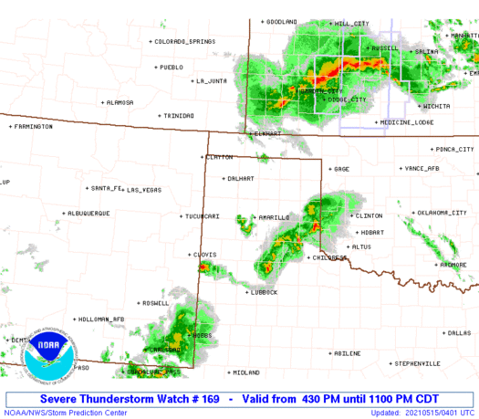
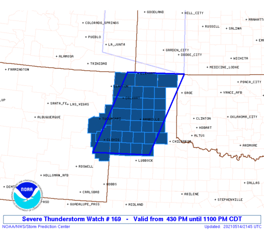
Severe Thunderstorm Watch Number 169
NWS Storm Prediction Center Norman OK
430 PM CDT Fri May 14 2021
The NWS Storm Prediction Center has issued a
* Severe Thunderstorm Watch for portions of
East-central New Mexico
Oklahoma Panhandle
Texas Panhandle
* Effective this Friday afternoon and evening from 430 PM until
1100 PM CDT.
* Primary threats include...
Scattered damaging winds and isolated significant gusts to 80
mph possible
Isolated very large hail events to 2 inches in diameter possible
SUMMARY...Initial discrete cells across east-central New Mexico
should consolidate into a modestly organized cluster with severe
wind and hail as the primary hazards.
The severe thunderstorm watch area is approximately along and 75
statute miles east and west of a line from 35 miles northeast of
Guymon OK to 50 miles west southwest of Plainview TX. For a complete
depiction of the watch see the associated watch outline update
(WOUS64 KWNS WOU9).
PRECAUTIONARY/PREPAREDNESS ACTIONS...
REMEMBER...A Severe Thunderstorm Watch means conditions are
favorable for severe thunderstorms in and close to the watch area.
Persons in these areas should be on the lookout for threatening
weather conditions and listen for later statements and possible
warnings. Severe thunderstorms can and occasionally do produce
tornadoes.
&&
AVIATION...A few severe thunderstorms with hail surface and aloft to
2 inches. Extreme turbulence and surface wind gusts to 70 knots. A
few cumulonimbi with maximum tops to 500. Mean storm motion vector
26030.
...Grams
 Note:
The Aviation Watch (SAW) product is an approximation to the watch area.
The actual watch is depicted by the shaded areas.
Note:
The Aviation Watch (SAW) product is an approximation to the watch area.
The actual watch is depicted by the shaded areas.
   SAW9
   WW 169 SEVERE TSTM NM OK TX 142130Z - 150400Z
   AXIS..75 STATUTE MILES EAST AND WEST OF LINE..
   35NE GUY/GUYMON OK/ - 50WSW PVW/PLAINVIEW TX/
   ..AVIATION COORDS.. 65NM E/W /4W LBL - 32WNW LBB/
   HAIL SURFACE AND ALOFT..2 INCHES. WIND GUSTS..70 KNOTS.
   MAX TOPS TO 500. MEAN STORM MOTION VECTOR 26030.

   LAT...LON 37039969 33880122 33880383 37030241

   THIS IS AN APPROXIMATION TO THE WATCH AREA.  FOR A
   COMPLETE DEPICTION OF THE WATCH SEE WOUS64 KWNS
   FOR WOU9.
Watch 169 Status Report Messages:
STATUS REPORT #6 ON WW 169

VALID 150325Z - 150400Z

SEVERE WEATHER THREAT CONTINUES RIGHT OF A LINE FROM 45 W LBB TO
35 WSW PVW TO 50 E BGD TO 55 WNW CSM.

WW 169 WILL BE ALLOWED TO EXPIRE AT 150400Z.

..DEAN..05/15/21

ATTN...WFO...ABQ...AMA...LUB...

&&

STATUS REPORT FOR WS 169

SEVERE WEATHER THREAT CONTINUES FOR THE FOLLOWING AREAS

TXC011-017-045-129-153-179-189-191-279-437-150400-

TX
.    TEXAS COUNTIES INCLUDED ARE

ARMSTRONG	     BAILEY		 BRISCOE
DONLEY		     FLOYD		 GRAY
HALE		     HALL		 LAMB
SWISHER
$$


THE WATCH STATUS MESSAGE IS FOR GUIDANCE PURPOSES ONLY.  PLEASE
REFER TO WATCH COUNTY NOTIFICATION STATEMENTS FOR OFFICIAL
INFORMATION ON COUNTIES...INDEPENDENT CITIES AND MARINE ZONES
CLEARED FROM SEVERE THUNDERSTORM AND TORNADO WATCHES.
$$

STATUS REPORT #5 ON WW 169

VALID 150250Z - 150340Z

SEVERE WEATHER THREAT CONTINUES RIGHT OF A LINE FROM 55 SE CVS TO
50 E BGD TO 55 WNW CSM.

FOR ADDITIONAL INFORMATION SEE MESOSCALE DISCUSSION 616

..DEAN..05/15/21

ATTN...WFO...ABQ...AMA...LUB...

&&

STATUS REPORT FOR WS 169

SEVERE WEATHER THREAT CONTINUES FOR THE FOLLOWING AREAS

TXC011-017-045-129-153-179-189-191-279-437-150340-

TX
.    TEXAS COUNTIES INCLUDED ARE

ARMSTRONG	     BAILEY		 BRISCOE
DONLEY		     FLOYD		 GRAY
HALE		     HALL		 LAMB
SWISHER
$$


THE WATCH STATUS MESSAGE IS FOR GUIDANCE PURPOSES ONLY.  PLEASE
REFER TO WATCH COUNTY NOTIFICATION STATEMENTS FOR OFFICIAL
INFORMATION ON COUNTIES...INDEPENDENT CITIES AND MARINE ZONES
CLEARED FROM SEVERE THUNDERSTORM AND TORNADO WATCHES.
$$

STATUS REPORT #4 ON WW 169

VALID 150155Z - 150240Z

SEVERE WEATHER THREAT CONTINUES RIGHT OF A LINE FROM 45 SE CVS TO
40 E CVS TO 15 SSW AMA TO 5 ENE BGD TO 25 NNE BGD TO 20 SSW EHA
TO 25 NNW EHA.

FOR ADDITIONAL INFORMATION SEE MESOSCALE DISCUSSION 616

..DEAN..05/15/21

ATTN...WFO...ABQ...AMA...LUB...

&&

STATUS REPORT FOR WS 169

SEVERE WEATHER THREAT CONTINUES FOR THE FOLLOWING AREAS

OKC007-139-150240-

OK
.    OKLAHOMA COUNTIES INCLUDED ARE

BEAVER		     TEXAS
$$


TXC011-017-045-065-069-129-153-179-189-191-195-233-279-357-381-
393-437-150240-

TX
.    TEXAS COUNTIES INCLUDED ARE

ARMSTRONG	     BAILEY		 BRISCOE
CARSON		     CASTRO		 DONLEY
FLOYD		     GRAY		 HALE
HALL		     HANSFORD		 HUTCHINSON
LAMB		     OCHILTREE		 RANDALL
ROBERTS 	     SWISHER
$$


THE WATCH STATUS MESSAGE IS FOR GUIDANCE PURPOSES ONLY.  PLEASE
REFER TO WATCH COUNTY NOTIFICATION STATEMENTS FOR OFFICIAL
INFORMATION ON COUNTIES...INDEPENDENT CITIES AND MARINE ZONES
CLEARED FROM SEVERE THUNDERSTORM AND TORNADO WATCHES.
$$

STATUS REPORT #3 ON WW 169

VALID 150025Z - 150140Z

SEVERE WEATHER THREAT CONTINUES RIGHT OF A LINE FROM 50 SSE CVS
TO 20 ESE CVS TO 35 SE DHT TO 15 NW EHA.

FOR ADDITIONAL INFORMATION SEE MESOSCALE DISCUSSION 613

..DEAN..05/15/21

ATTN...WFO...ABQ...AMA...LUB...

&&

STATUS REPORT FOR WS 169

SEVERE WEATHER THREAT CONTINUES FOR THE FOLLOWING AREAS

OKC007-025-139-150140-

OK
.    OKLAHOMA COUNTIES INCLUDED ARE

BEAVER		     CIMARRON		 TEXAS
$$


TXC011-017-045-065-069-117-129-153-179-189-191-195-233-279-341-
357-359-369-375-381-393-421-437-150140-

TX
.    TEXAS COUNTIES INCLUDED ARE

ARMSTRONG	     BAILEY		 BRISCOE
CARSON		     CASTRO		 DEAF SMITH
DONLEY		     FLOYD		 GRAY
HALE		     HALL		 HANSFORD
HUTCHINSON	     LAMB		 MOORE
OCHILTREE	     OLDHAM		 PARMER
POTTER		     RANDALL		 ROBERTS
SHERMAN 	     SWISHER
$$


THE WATCH STATUS MESSAGE IS FOR GUIDANCE PURPOSES ONLY.  PLEASE
REFER TO WATCH COUNTY NOTIFICATION STATEMENTS FOR OFFICIAL
INFORMATION ON COUNTIES...INDEPENDENT CITIES AND MARINE ZONES
CLEARED FROM SEVERE THUNDERSTORM AND TORNADO WATCHES.
$$

STATUS REPORT #2 ON WW 169

VALID 142340Z - 150040Z

SEVERE WEATHER THREAT CONTINUES RIGHT OF A LINE FROM 50 N HOB TO
30 SSW DHT TO 20 ESE SPD.

FOR ADDITIONAL INFORMATION SEE MESOSCALE DISCUSSION 613

..DEAN..05/14/21

ATTN...WFO...ABQ...AMA...LUB...

&&

STATUS REPORT FOR WS 169

SEVERE WEATHER THREAT CONTINUES FOR THE FOLLOWING AREAS

OKC007-025-139-150040-

OK
.    OKLAHOMA COUNTIES INCLUDED ARE

BEAVER		     CIMARRON		 TEXAS
$$


TXC011-017-045-065-069-111-117-129-153-179-189-191-195-205-233-
279-341-357-359-369-375-381-393-421-437-150040-

TX
.    TEXAS COUNTIES INCLUDED ARE

ARMSTRONG	     BAILEY		 BRISCOE
CARSON		     CASTRO		 DALLAM
DEAF SMITH	     DONLEY		 FLOYD
GRAY		     HALE		 HALL
HANSFORD	     HARTLEY		 HUTCHINSON
LAMB		     MOORE		 OCHILTREE
OLDHAM		     PARMER		 POTTER
RANDALL 	     ROBERTS		 SHERMAN
SWISHER
$$


THE WATCH STATUS MESSAGE IS FOR GUIDANCE PURPOSES ONLY.  PLEASE
REFER TO WATCH COUNTY NOTIFICATION STATEMENTS FOR OFFICIAL
INFORMATION ON COUNTIES...INDEPENDENT CITIES AND MARINE ZONES
CLEARED FROM SEVERE THUNDERSTORM AND TORNADO WATCHES.
$$

STATUS REPORT #1 ON WW 169

VALID 142235Z - 142340Z

THE SEVERE WEATHER THREAT CONTINUES ACROSS THE ENTIRE WATCH AREA.

..DEAN..05/14/21

ATTN...WFO...ABQ...AMA...LUB...

&&

STATUS REPORT FOR WS 169

SEVERE WEATHER THREAT CONTINUES FOR THE FOLLOWING AREAS

NMC009-037-041-142340-

NM
.    NEW MEXICO COUNTIES INCLUDED ARE

CURRY		     QUAY		 ROOSEVELT
$$


OKC007-025-139-142340-

OK
.    OKLAHOMA COUNTIES INCLUDED ARE

BEAVER		     CIMARRON		 TEXAS
$$


TXC011-017-045-065-069-111-117-129-153-179-189-191-195-205-233-
279-341-357-359-369-375-381-393-421-437-142340-

TX
.    TEXAS COUNTIES INCLUDED ARE

ARMSTRONG	     BAILEY		 BRISCOE
CARSON		     CASTRO		 DALLAM
DEAF SMITH	     DONLEY		 FLOYD
GRAY		     HALE		 HALL
HANSFORD	     HARTLEY		 HUTCHINSON
LAMB		     MOORE		 OCHILTREE
OLDHAM		     PARMER		 POTTER
RANDALL 	     ROBERTS		 SHERMAN
SWISHER
$$


THE WATCH STATUS MESSAGE IS FOR GUIDANCE PURPOSES ONLY.  PLEASE
REFER TO WATCH COUNTY NOTIFICATION STATEMENTS FOR OFFICIAL
INFORMATION ON COUNTIES...INDEPENDENT CITIES AND MARINE ZONES
CLEARED FROM SEVERE THUNDERSTORM AND TORNADO WATCHES.
$$
Note:
Click for Complete Product Text.
Tornadoes
Probability of 2 or more tornadoes
|
Low (10%)
|
Probability of 1 or more strong (EF2-EF5) tornadoes
|
Low (<2%)
|
Wind
Probability of 10 or more severe wind events
|
Mod (40%)
|
Probability of 1 or more wind events > 65 knots
|
Mod (40%)
|
Hail
Probability of 10 or more severe hail events
|
Mod (30%)
|
Probability of 1 or more hailstones > 2 inches
|
Mod (30%)
|
Combined Severe Hail/Wind
Probability of 6 or more combined severe hail/wind events
|
High (70%)
|
For each watch, probabilities for particular events inside the watch
(listed above in each table) are determined by the issuing forecaster.
The "Low" category contains probability values ranging from less than 2%
to 20% (EF2-EF5 tornadoes), less than 5% to 20% (all other probabilities),
"Moderate" from 30% to 60%, and "High" from 70% to greater than 95%.
High values are bolded and lighter in color to provide awareness of
an increased threat for a particular event.


 @NWSSPC


