Note:
The expiration time in the watch graphic is amended if the watch is
replaced, cancelled or extended.
Note:
Note:
The expiration time in the watch graphic is amended if the watch is
replaced, cancelled or extended.
Note: Click for
Watch Status Reports.
SEL7
URGENT - IMMEDIATE BROADCAST REQUESTED
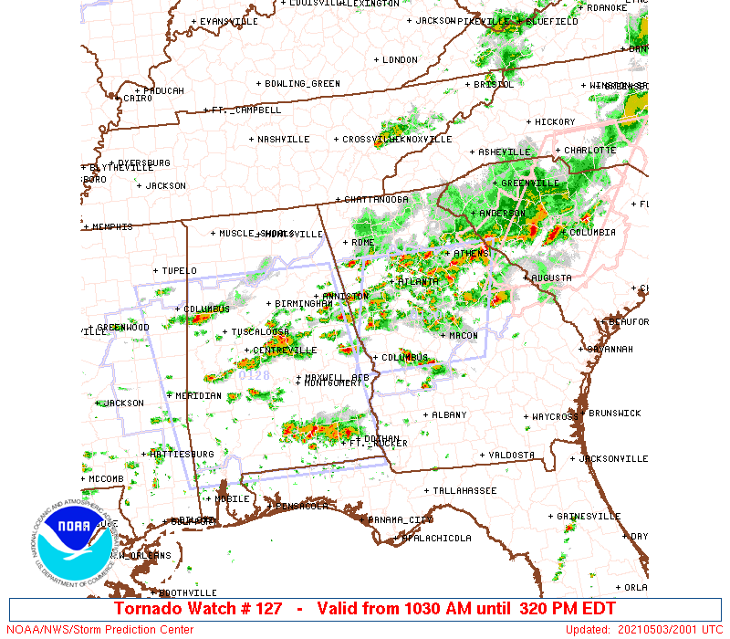
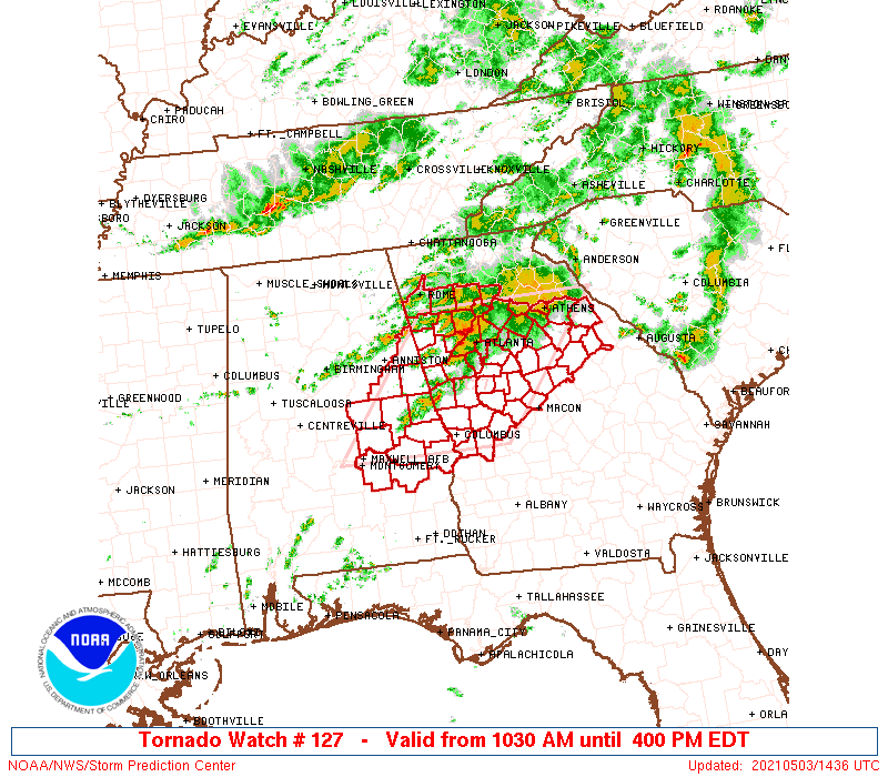
Tornado Watch Number 127
NWS Storm Prediction Center Norman OK
1030 AM EDT Mon May 3 2021
The NWS Storm Prediction Center has issued a
* Tornado Watch for portions of
East-central Alabama
Northern and central Georgia
* Effective this Monday morning and afternoon from 1030 AM until
400 PM EDT.
* Primary threats include...
A few tornadoes and a couple intense tornadoes possible
Isolated damaging wind gusts to 70 mph possible
SUMMARY...Multiple supercells may continue to produce tornadoes in
clusters across east-central Alabama through northern and central
Georgia.
The tornado watch area is approximately along and 75 statute miles
east and west of a line from 20 miles south of Auburn AL to 35 miles
west northwest of Athens GA. For a complete depiction of the watch
see the associated watch outline update (WOUS64 KWNS WOU7).
PRECAUTIONARY/PREPAREDNESS ACTIONS...
REMEMBER...A Tornado Watch means conditions are favorable for
tornadoes and severe thunderstorms in and close to the watch
area. Persons in these areas should be on the lookout for
threatening weather conditions and listen for later statements
and possible warnings.
&&
AVIATION...Tornadoes and a few severe thunderstorms with hail
surface and aloft to 1.5 inches. Extreme turbulence and surface wind
gusts to 60 knots. A few cumulonimbi with maximum tops to 550. Mean
storm motion vector 26025.
...Grams
 Note:
The Aviation Watch (SAW) product is an approximation to the watch area.
The actual watch is depicted by the shaded areas.
Note:
The Aviation Watch (SAW) product is an approximation to the watch area.
The actual watch is depicted by the shaded areas.
   SAW7
   WW 127 TORNADO AL GA 031430Z - 032000Z
   AXIS..75 STATUTE MILES EAST AND WEST OF LINE..
   20S AUO/AUBURN AL/ - 35WNW AHN/ATHENS GA/
   ..AVIATION COORDS.. 65NM E/W /45SSW LGC - 41NE ATL/
   HAIL SURFACE AND ALOFT..1.5 INCHES. WIND GUSTS..60 KNOTS.
   MAX TOPS TO 550. MEAN STORM MOTION VECTOR 26025.

   LAT...LON 32318671 34148521 34148258 32318415

   THIS IS AN APPROXIMATION TO THE WATCH AREA.  FOR A
   COMPLETE DEPICTION OF THE WATCH SEE WOUS64 KWNS
   FOR WOU7.
Watch 127 Status Report Messages:
STATUS REPORT #3 ON WW 127

VALID 031850Z - 031940Z

SEVERE WEATHER THREAT CONTINUES RIGHT OF A LINE FROM 15 SSW CSG
TO 30 SSW RMG.

..DIAL..05/03/21

ATTN...WFO...BMX...FFC...

&&

STATUS REPORT FOR WT 127

SEVERE WEATHER THREAT CONTINUES FOR THE FOLLOWING AREAS

GAC009-013-015-021-035-045-053-057-059-063-067-077-079-089-097-
113-115-117-121-133-135-141-143-145-149-151-159-169-171-197-199-
207-211-215-217-219-221-223-231-233-237-247-255-263-265-269-285-
293-297-301-317-031940-

GA
.    GEORGIA COUNTIES INCLUDED ARE

BALDWIN 	     BARROW		 BARTOW
BIBB		     BUTTS		 CARROLL
CHATTAHOOCHEE	     CHEROKEE		 CLARKE
CLAYTON 	     COBB		 COWETA
CRAWFORD	     DEKALB		 DOUGLAS
FAYETTE 	     FLOYD		 FORSYTH
FULTON		     GREENE		 GWINNETT
HANCOCK 	     HARALSON		 HARRIS
HEARD		     HENRY		 JASPER
JONES		     LAMAR		 MARION
MERIWETHER	     MONROE		 MORGAN
MUSCOGEE	     NEWTON		 OCONEE
OGLETHORPE	     PAULDING		 PIKE
POLK		     PUTNAM		 ROCKDALE
SPALDING	     TALBOT		 TALIAFERRO
TAYLOR		     TROUP		 UPSON
WALTON		     WARREN		 WILKES
$$


THE WATCH STATUS MESSAGE IS FOR GUIDANCE PURPOSES ONLY.  PLEASE
REFER TO WATCH COUNTY NOTIFICATION STATEMENTS FOR OFFICIAL
INFORMATION ON COUNTIES...INDEPENDENT CITIES AND MARINE ZONES
CLEARED FROM SEVERE THUNDERSTORM AND TORNADO WATCHES.
$$

STATUS REPORT #2 ON WW 127

VALID 031710Z - 031840Z

SEVERE WEATHER THREAT CONTINUES RIGHT OF A LINE FROM 20 SW CSG TO
35 SSW RMG.

FOR ADDITIONAL INFORMATION SEE MESOSCALE DISCUSSION 491

..DIAL..05/03/21

ATTN...WFO...BMX...FFC...

&&

STATUS REPORT FOR WT 127

SEVERE WEATHER THREAT CONTINUES FOR THE FOLLOWING AREAS

GAC009-013-015-021-035-045-053-057-059-063-067-077-079-089-097-
113-115-117-121-133-135-141-143-145-149-151-159-169-171-197-199-
207-211-215-217-219-221-223-231-233-237-247-255-263-265-269-285-
293-297-301-317-031840-

GA
.    GEORGIA COUNTIES INCLUDED ARE

BALDWIN 	     BARROW		 BARTOW
BIBB		     BUTTS		 CARROLL
CHATTAHOOCHEE	     CHEROKEE		 CLARKE
CLAYTON 	     COBB		 COWETA
CRAWFORD	     DEKALB		 DOUGLAS
FAYETTE 	     FLOYD		 FORSYTH
FULTON		     GREENE		 GWINNETT
HANCOCK 	     HARALSON		 HARRIS
HEARD		     HENRY		 JASPER
JONES		     LAMAR		 MARION
MERIWETHER	     MONROE		 MORGAN
MUSCOGEE	     NEWTON		 OCONEE
OGLETHORPE	     PAULDING		 PIKE
POLK		     PUTNAM		 ROCKDALE
SPALDING	     TALBOT		 TALIAFERRO
TAYLOR		     TROUP		 UPSON
WALTON		     WARREN		 WILKES
$$


THE WATCH STATUS MESSAGE IS FOR GUIDANCE PURPOSES ONLY.  PLEASE
REFER TO WATCH COUNTY NOTIFICATION STATEMENTS FOR OFFICIAL
INFORMATION ON COUNTIES...INDEPENDENT CITIES AND MARINE ZONES
CLEARED FROM SEVERE THUNDERSTORM AND TORNADO WATCHES.
$$

STATUS REPORT #1 ON WW 127

VALID 031605Z - 031740Z

THE SEVERE WEATHER THREAT CONTINUES ACROSS THE ENTIRE WATCH AREA.

..DIAL..05/03/21

ATTN...WFO...BMX...FFC...

&&

STATUS REPORT FOR WT 127

SEVERE WEATHER THREAT CONTINUES FOR THE FOLLOWING AREAS

ALC011-017-027-029-037-051-081-087-101-111-113-123-031740-

AL
.    ALABAMA COUNTIES INCLUDED ARE

BULLOCK 	     CHAMBERS		 CLAY
CLEBURNE	     COOSA		 ELMORE
LEE		     MACON		 MONTGOMERY
RANDOLPH	     RUSSELL		 TALLAPOOSA
$$


GAC009-013-015-021-035-045-053-057-059-063-067-077-079-089-097-
113-115-117-121-133-135-141-143-145-149-151-159-169-171-197-199-
207-211-215-217-219-221-223-231-233-237-247-255-263-265-269-285-
293-297-301-317-031740-

GA
.    GEORGIA COUNTIES INCLUDED ARE

BALDWIN 	     BARROW		 BARTOW
BIBB		     BUTTS		 CARROLL
CHATTAHOOCHEE	     CHEROKEE		 CLARKE
CLAYTON 	     COBB		 COWETA
CRAWFORD	     DEKALB		 DOUGLAS
FAYETTE 	     FLOYD		 FORSYTH
FULTON		     GREENE		 GWINNETT
HANCOCK 	     HARALSON		 HARRIS
HEARD		     HENRY		 JASPER
JONES		     LAMAR		 MARION
MERIWETHER	     MONROE		 MORGAN
MUSCOGEE	     NEWTON		 OCONEE
OGLETHORPE	     PAULDING		 PIKE
POLK		     PUTNAM		 ROCKDALE
SPALDING	     TALBOT		 TALIAFERRO
TAYLOR		     TROUP		 UPSON
WALTON		     WARREN		 WILKES
$$


THE WATCH STATUS MESSAGE IS FOR GUIDANCE PURPOSES ONLY.  PLEASE
REFER TO WATCH COUNTY NOTIFICATION STATEMENTS FOR OFFICIAL
INFORMATION ON COUNTIES...INDEPENDENT CITIES AND MARINE ZONES
CLEARED FROM SEVERE THUNDERSTORM AND TORNADO WATCHES.
$$
Note:
Click for Complete Product Text.
Tornadoes
Probability of 2 or more tornadoes
|
Mod (50%)
|
Probability of 1 or more strong (EF2-EF5) tornadoes
|
Mod (40%)
|
Wind
Probability of 10 or more severe wind events
|
Mod (30%)
|
Probability of 1 or more wind events > 65 knots
|
Low (20%)
|
Hail
Probability of 10 or more severe hail events
|
Low (10%)
|
Probability of 1 or more hailstones > 2 inches
|
Low (10%)
|
Combined Severe Hail/Wind
Probability of 6 or more combined severe hail/wind events
|
Mod (50%)
|
For each watch, probabilities for particular events inside the watch
(listed above in each table) are determined by the issuing forecaster.
The "Low" category contains probability values ranging from less than 2%
to 20% (EF2-EF5 tornadoes), less than 5% to 20% (all other probabilities),
"Moderate" from 30% to 60%, and "High" from 70% to greater than 95%.
High values are bolded and lighter in color to provide awareness of
an increased threat for a particular event.


 @NWSSPC