Note:
The expiration time in the watch graphic is amended if the watch is
replaced, cancelled or extended.
Note:
Note:
The expiration time in the watch graphic is amended if the watch is
replaced, cancelled or extended.
Note: Click for
Watch Status Reports.
SEL5
URGENT - IMMEDIATE BROADCAST REQUESTED
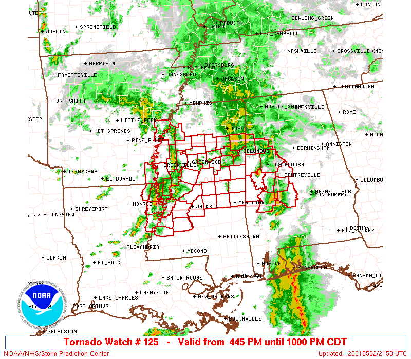
Tornado Watch Number 125
NWS Storm Prediction Center Norman OK
445 PM CDT Sun May 2 2021
The NWS Storm Prediction Center has issued a
* Tornado Watch for portions of
West central Alabama
Extreme southeastern Arkansas
Extreme northeastern Louisiana
Parts of central and northern Mississippi
* Effective this Sunday afternoon and evening from 445 PM until
1000 PM CDT.
* Primary threats include...
A couple tornadoes possible
Scattered damaging wind gusts to 70 mph possible
Isolated large hail events to 1 inch in diameter possible
SUMMARY...Scattered low-topped supercells are expected in a loose
arc/cluster from northeastern Louisiana into central and parts of
northern Mississippi this evening, and a somewhat separate zone of
low-topped supercells may persist for a few more hours along a
surface warm front across west central Alabama. The stronger storms
may produce a couple of tornadoes, along with isolated damaging
winds and marginally severe hail.
The tornado watch area is approximately along and 60 statute miles
north and south of a line from 25 miles south southwest of
Greenville MS to 20 miles southeast of Tuscaloosa AL. For a complete
depiction of the watch see the associated watch outline update
(WOUS64 KWNS WOU5).
PRECAUTIONARY/PREPAREDNESS ACTIONS...
REMEMBER...A Tornado Watch means conditions are favorable for
tornadoes and severe thunderstorms in and close to the watch
area. Persons in these areas should be on the lookout for
threatening weather conditions and listen for later statements
and possible warnings.
&&
OTHER WATCH INFORMATION...CONTINUE...WW 124...
AVIATION...Tornadoes and a few severe thunderstorms with hail
surface and aloft to 1 inch. Extreme turbulence and surface wind
gusts to 60 knots. A few cumulonimbi with maximum tops to 450. Mean
storm motion vector 23030.
...Thompson

   SEL5

   URGENT - IMMEDIATE BROADCAST REQUESTED
   Tornado Watch Number 125
   NWS Storm Prediction Center Norman OK
   445 PM CDT Sun May 2 2021

   The NWS Storm Prediction Center has issued a

   * Tornado Watch for portions of
     West central Alabama
     Extreme southeastern Arkansas
     Extreme northeastern Louisiana
     Parts of central and northern Mississippi

   * Effective this Sunday afternoon and evening from 445 PM until
     1000 PM CDT.

   * Primary threats include...
     A couple tornadoes possible
     Scattered damaging wind gusts to 70 mph possible
     Isolated large hail events to 1 inch in diameter possible

   SUMMARY...Scattered low-topped supercells are expected in a loose
   arc/cluster from northeastern Louisiana into central and parts of
   northern Mississippi this evening, and a somewhat separate zone of
   low-topped supercells may persist for a few more hours along a
   surface warm front across west central Alabama.  The stronger storms
   may produce a couple of tornadoes, along with isolated damaging
   winds and marginally severe hail.

   The tornado watch area is approximately along and 60 statute miles
   north and south of a line from 25 miles south southwest of
   Greenville MS to 20 miles southeast of Tuscaloosa AL. For a complete
   depiction of the watch see the associated watch outline update
   (WOUS64 KWNS WOU5).

   PRECAUTIONARY/PREPAREDNESS ACTIONS...

   REMEMBER...A Tornado Watch means conditions are favorable for
   tornadoes and severe thunderstorms in and close to the watch
   area. Persons in these areas should be on the lookout for
   threatening weather conditions and listen for later statements
   and possible warnings.

   &&

   OTHER WATCH INFORMATION...CONTINUE...WW 124...

   AVIATION...Tornadoes and a few severe thunderstorms with hail
   surface and aloft to 1 inch. Extreme turbulence and surface wind
   gusts to 60 knots. A few cumulonimbi with maximum tops to 450. Mean
   storm motion vector 23030.

   ...Thompson
 Note:
The Aviation Watch (SAW) product is an approximation to the watch area.
The actual watch is depicted by the shaded areas.
Note:
The Aviation Watch (SAW) product is an approximation to the watch area.
The actual watch is depicted by the shaded areas.
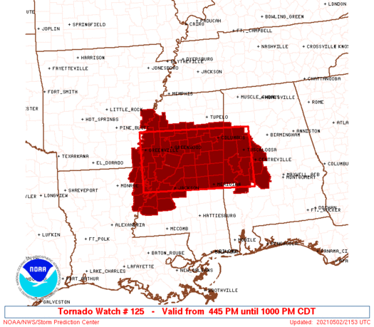
   SAW5
   WW 125 TORNADO AL AR LA MS 022145Z - 030300Z
   AXIS..60 STATUTE MILES NORTH AND SOUTH OF LINE..
   25SSW GLH/GREENVILLE MS/ - 20SE TCL/TUSCALOOSA AL/
   ..AVIATION COORDS.. 50NM N/S /48WSW SQS - 46SSW VUZ/
   HAIL SURFACE AND ALOFT..1 INCH. WIND GUSTS..60 KNOTS.
   MAX TOPS TO 450. MEAN STORM MOTION VECTOR 23030.

   LAT...LON 34009115 33888738 32158738 32279115

   THIS IS AN APPROXIMATION TO THE WATCH AREA.  FOR A
   COMPLETE DEPICTION OF THE WATCH SEE WOUS64 KWNS
   FOR WOU5.
Watch 125 Status Report Messages:
STATUS REPORT #3 ON WW 125

VALID 030145Z - 030240Z

SEVERE WEATHER THREAT CONTINUES RIGHT OF A LINE FROM 55 W MEI TO
65 S GWO TO 45 S GWO TO 20 SE GWO TO 30 NE GWO TO 30 S UOX TO 15
SSE UOX TO 15 ENE UOX.

..LYONS..05/03/21

ATTN...WFO...BMX...JAN...MEG...

&&

STATUS REPORT FOR WT 125

SEVERE WEATHER THREAT CONTINUES FOR THE FOLLOWING AREAS

ALC057-075-107-125-030240-

AL
.    ALABAMA COUNTIES INCLUDED ARE

FAYETTE 	     LAMAR		 PICKENS
TUSCALOOSA
$$


MSC007-013-017-019-025-051-069-079-087-095-097-099-101-103-105-
123-155-159-030240-

MS
.    MISSISSIPPI COUNTIES INCLUDED ARE

ATTALA		     CALHOUN		 CHICKASAW
CHOCTAW 	     CLAY		 HOLMES
KEMPER		     LEAKE		 LOWNDES
MONROE		     MONTGOMERY 	 NESHOBA
NEWTON		     NOXUBEE		 OKTIBBEHA
SCOTT		     WEBSTER		 WINSTON
$$


THE WATCH STATUS MESSAGE IS FOR GUIDANCE PURPOSES ONLY.  PLEASE
REFER TO WATCH COUNTY NOTIFICATION STATEMENTS FOR OFFICIAL
INFORMATION ON COUNTIES...INDEPENDENT CITIES AND MARINE ZONES
CLEARED FROM SEVERE THUNDERSTORM AND TORNADO WATCHES.
$$

STATUS REPORT #2 ON WW 125

VALID 030045Z - 030140Z

SEVERE WEATHER THREAT CONTINUES RIGHT OF A LINE FROM 35 ENE HEZ
TO 50 NNE HEZ TO 50 S GLH TO 25 S GWO TO 10 N GWO TO 40 NNW GWO
TO 35 SSW MEM.

FOR ADDITIONAL INFORMATION SEE MESOSCALE DISCUSSION 480

..LYONS..05/03/21

ATTN...WFO...BMX...JAN...MEG...

&&

STATUS REPORT FOR WT 125

SEVERE WEATHER THREAT CONTINUES FOR THE FOLLOWING AREAS

ALC057-063-075-107-119-125-030140-

AL
.    ALABAMA COUNTIES INCLUDED ARE

FAYETTE 	     GREENE		 LAMAR
PICKENS 	     SUMTER		 TUSCALOOSA
$$


MSC007-013-015-017-019-025-043-049-051-069-075-079-087-089-095-
097-099-101-103-105-121-123-135-149-155-159-161-163-030140-

MS
.    MISSISSIPPI COUNTIES INCLUDED ARE

ATTALA		     CALHOUN		 CARROLL
CHICKASAW	     CHOCTAW		 CLAY
GRENADA 	     HINDS		 HOLMES
KEMPER		     LAUDERDALE 	 LEAKE
LOWNDES 	     MADISON		 MONROE
MONTGOMERY	     NESHOBA		 NEWTON
NOXUBEE 	     OKTIBBEHA		 RANKIN
SCOTT		     TALLAHATCHIE	 WARREN
WEBSTER 	     WINSTON		 YALOBUSHA
YAZOO
$$


THE WATCH STATUS MESSAGE IS FOR GUIDANCE PURPOSES ONLY.  PLEASE
REFER TO WATCH COUNTY NOTIFICATION STATEMENTS FOR OFFICIAL
INFORMATION ON COUNTIES...INDEPENDENT CITIES AND MARINE ZONES
CLEARED FROM SEVERE THUNDERSTORM AND TORNADO WATCHES.
$$

STATUS REPORT #1 ON WW 125

VALID 022320Z - 030040Z

SEVERE WEATHER THREAT CONTINUES RIGHT OF A LINE FROM 35 E MLU TO
45 SSW GLH TO 20 SW GLH TO 20 NNW GLH TO 45 N GLH TO 60 SW MEM TO
45 SW MEM.

..LYONS..05/02/21

ATTN...WFO...BMX...JAN...MEG...

&&

STATUS REPORT FOR WT 125

SEVERE WEATHER THREAT CONTINUES FOR THE FOLLOWING AREAS

ALC007-047-057-063-065-075-091-105-107-119-125-030040-

AL
.    ALABAMA COUNTIES INCLUDED ARE

BIBB		     DALLAS		 FAYETTE
GREENE		     HALE		 LAMAR
MARENGO 	     PERRY		 PICKENS
SUMTER		     TUSCALOOSA
$$


LAC065-107-030040-

LA
.    LOUISIANA PARISHES INCLUDED ARE

MADISON 	     TENSAS
$$


MSC007-011-013-015-017-019-021-025-027-029-043-049-051-053-055-
063-069-075-079-083-087-089-095-097-099-101-103-105-119-121-123-
125-133-135-149-151-155-159-161-163-030040-

MS
.    MISSISSIPPI COUNTIES INCLUDED ARE

ATTALA		     BOLIVAR		 CALHOUN
CARROLL 	     CHICKASAW		 CHOCTAW
CLAIBORNE	     CLAY		 COAHOMA
COPIAH		     GRENADA		 HINDS
HOLMES		     HUMPHREYS		 ISSAQUENA
JEFFERSON	     KEMPER		 LAUDERDALE
LEAKE		     LEFLORE		 LOWNDES
MADISON 	     MONROE		 MONTGOMERY
NESHOBA 	     NEWTON		 NOXUBEE
OKTIBBEHA	     QUITMAN		 RANKIN
SCOTT		     SHARKEY		 SUNFLOWER
TALLAHATCHIE	     WARREN		 WASHINGTON
WEBSTER 	     WINSTON		 YALOBUSHA
YAZOO
$$


THE WATCH STATUS MESSAGE IS FOR GUIDANCE PURPOSES ONLY.  PLEASE
REFER TO WATCH COUNTY NOTIFICATION STATEMENTS FOR OFFICIAL
INFORMATION ON COUNTIES...INDEPENDENT CITIES AND MARINE ZONES
CLEARED FROM SEVERE THUNDERSTORM AND TORNADO WATCHES.
$$
Note:
Click for Complete Product Text.
Tornadoes
Probability of 2 or more tornadoes
|
Mod (40%)
|
Probability of 1 or more strong (EF2-EF5) tornadoes
|
Low (20%)
|
Wind
Probability of 10 or more severe wind events
|
Mod (40%)
|
Probability of 1 or more wind events > 65 knots
|
Low (20%)
|
Hail
Probability of 10 or more severe hail events
|
Low (20%)
|
Probability of 1 or more hailstones > 2 inches
|
Low (<5%)
|
Combined Severe Hail/Wind
Probability of 6 or more combined severe hail/wind events
|
Mod (60%)
|
For each watch, probabilities for particular events inside the watch
(listed above in each table) are determined by the issuing forecaster.
The "Low" category contains probability values ranging from less than 2%
to 20% (EF2-EF5 tornadoes), less than 5% to 20% (all other probabilities),
"Moderate" from 30% to 60%, and "High" from 70% to greater than 95%.
High values are bolded and lighter in color to provide awareness of
an increased threat for a particular event.


 @NWSSPC