Note:
The expiration time in the watch graphic is amended if the watch is
replaced, cancelled or extended.
Note:
Note:
The expiration time in the watch graphic is amended if the watch is
replaced, cancelled or extended.
Note: Click for
Watch Status Reports.
SEL2
URGENT - IMMEDIATE BROADCAST REQUESTED
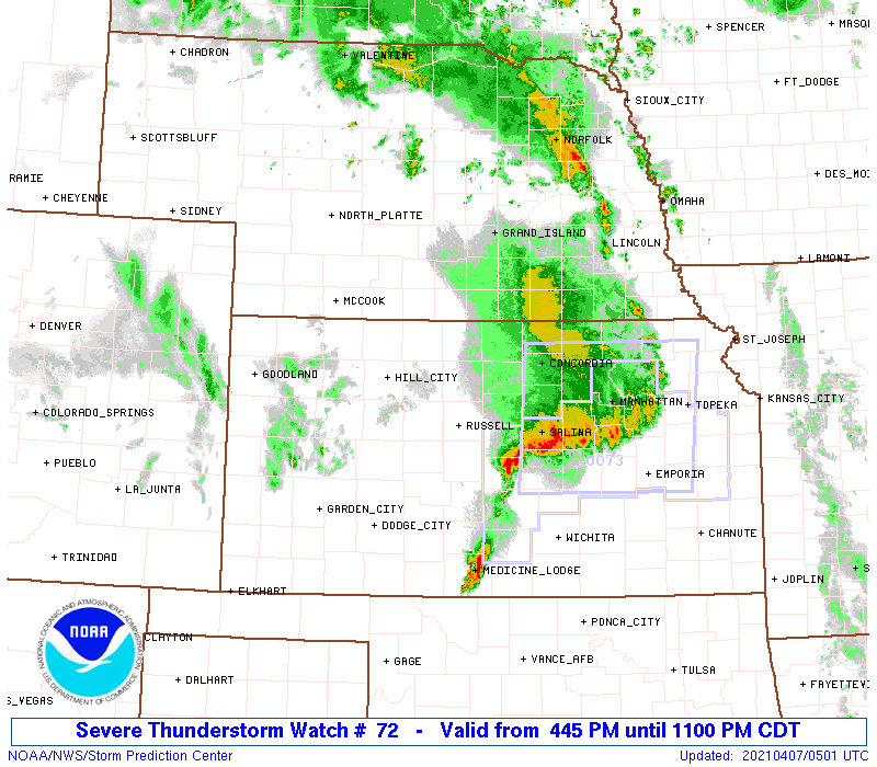
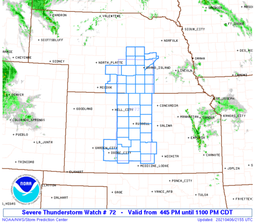
Severe Thunderstorm Watch Number 72
NWS Storm Prediction Center Norman OK
445 PM CDT Tue Apr 6 2021
The NWS Storm Prediction Center has issued a
* Severe Thunderstorm Watch for portions of
Central Kansas
South central Nebraska
* Effective this Tuesday afternoon and evening from 445 PM until
1100 PM CDT.
* Primary threats include...
Scattered large hail and isolated very large hail events to 2
inches in diameter possible
Scattered damaging wind gusts to 70 mph possible
A tornado or two possible
SUMMARY...Thunderstorm initiation appears imminent just to the east
of Dodge City, and near the surface low in south central Nebraska.
The storm environment favors a mix of multicell clusters to the
north with an accompanying large hail and damaging wind threat, and
supercells farther south toward central and south central Kansas.
In addition to the hail/wind threat, there will be some potential
for a tornado or two with the southernmost supercells in a cluster
across Kansas this evening.
The severe thunderstorm watch area is approximately along and 45
statute miles east and west of a line from 30 miles northwest of
Grand Island NE to 95 miles south of Russell KS. For a complete
depiction of the watch see the associated watch outline update
(WOUS64 KWNS WOU2).
PRECAUTIONARY/PREPAREDNESS ACTIONS...
REMEMBER...A Severe Thunderstorm Watch means conditions are
favorable for severe thunderstorms in and close to the watch area.
Persons in these areas should be on the lookout for threatening
weather conditions and listen for later statements and possible
warnings. Severe thunderstorms can and occasionally do produce
tornadoes.
&&
AVIATION...A few severe thunderstorms with hail surface and aloft to
2 inches. Extreme turbulence and surface wind gusts to 60 knots. A
few cumulonimbi with maximum tops to 500. Mean storm motion vector
24025.
...Thompson
   SEL2

   URGENT - IMMEDIATE BROADCAST REQUESTED
   Severe Thunderstorm Watch Number 72
   NWS Storm Prediction Center Norman OK
   445 PM CDT Tue Apr 6 2021

   The NWS Storm Prediction Center has issued a

   * Severe Thunderstorm Watch for portions of
     Central Kansas
     South central Nebraska

   * Effective this Tuesday afternoon and evening from 445 PM until
     1100 PM CDT.

   * Primary threats include...
     Scattered large hail and isolated very large hail events to 2
       inches in diameter possible
     Scattered damaging wind gusts to 70 mph possible
     A tornado or two possible

   SUMMARY...Thunderstorm initiation appears imminent just to the east
   of Dodge City, and near the surface low in south central Nebraska.
   The storm environment favors a mix of multicell clusters to the
   north with an accompanying large hail and damaging wind threat, and
   supercells farther south toward central and south central Kansas.
   In addition to the hail/wind threat, there will be some potential
   for a tornado or two with the southernmost supercells in a cluster
   across Kansas this evening.

   The severe thunderstorm watch area is approximately along and 45
   statute miles east and west of a line from 30 miles northwest of
   Grand Island NE to 95 miles south of Russell KS. For a complete
   depiction of the watch see the associated watch outline update
   (WOUS64 KWNS WOU2).

   PRECAUTIONARY/PREPAREDNESS ACTIONS...

   REMEMBER...A Severe Thunderstorm Watch means conditions are
   favorable for severe thunderstorms in and close to the watch area.
   Persons in these areas should be on the lookout for threatening
   weather conditions and listen for later statements and possible
   warnings. Severe thunderstorms can and occasionally do produce
   tornadoes.

   &&

   AVIATION...A few severe thunderstorms with hail surface and aloft to
   2 inches. Extreme turbulence and surface wind gusts to 60 knots. A
   few cumulonimbi with maximum tops to 500. Mean storm motion vector
   24025.

   ...Thompson
 Note:
The Aviation Watch (SAW) product is an approximation to the watch area.
The actual watch is depicted by the shaded areas.
Note:
The Aviation Watch (SAW) product is an approximation to the watch area.
The actual watch is depicted by the shaded areas.
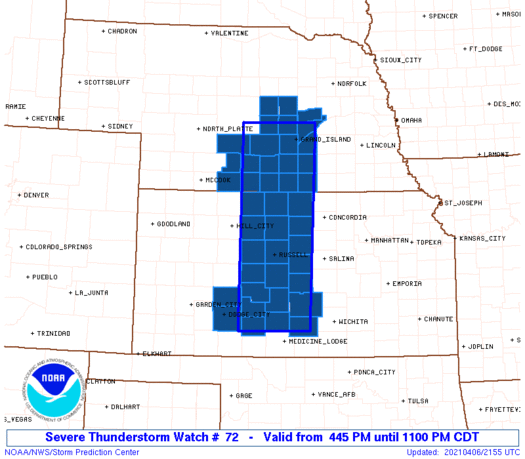
   SAW2
   WW 72 SEVERE TSTM KS NE 062145Z - 070400Z
   AXIS..45 STATUTE MILES EAST AND WEST OF LINE..
   30NW GRI/GRAND ISLAND NE/ - 95S RSL/RUSSELL KS/
   ..AVIATION COORDS.. 40NM E/W /18WSW OBH - 61WSW ICT/
   HAIL SURFACE AND ALOFT..2 INCHES. WIND GUSTS..60 KNOTS.
   MAX TOPS TO 500. MEAN STORM MOTION VECTOR 24025.

   LAT...LON 41279786 37489800 37489964 41279960

   THIS IS AN APPROXIMATION TO THE WATCH AREA.  FOR A
   COMPLETE DEPICTION OF THE WATCH SEE WOUS64 KWNS
   FOR WOU2.
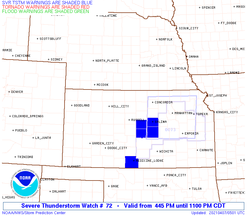
Watch 72 Status Report Messages:
STATUS REPORT #2 ON WW 72
VALID 070300Z - 070400Z
SEVERE WEATHER THREAT CONTINUES RIGHT OF A LINE FROM 15 SSW HUT
TO 45 S RSL TO 20 S RSL TO 25 NNW SLN.
WW 72 WILL BE ALLOWED TO EXPIRE AT 070400Z.
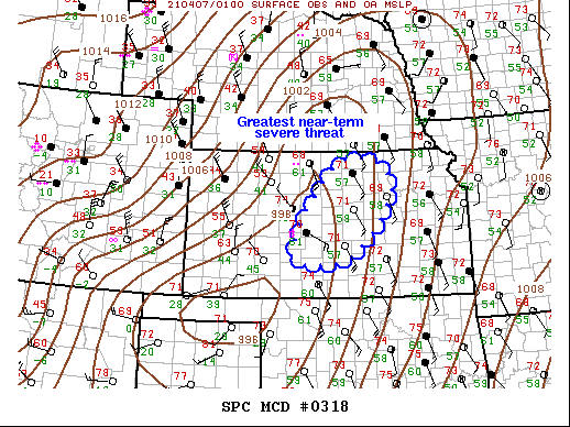
FOR ADDITIONAL INFORMATION SEE MESOSCALE DISCUSSION 318
..THOMPSON..04/07/21
ATTN...WFO...ICT...DDC...
&&
STATUS REPORT FOR WS 72
SEVERE WEATHER THREAT CONTINUES FOR THE FOLLOWING AREAS
KSC009-047-053-095-097-105-145-151-155-159-185-070400-
KS
. KANSAS COUNTIES INCLUDED ARE
BARTON EDWARDS ELLSWORTH
KINGMAN KIOWA LINCOLN
PAWNEE PRATT RENO
RICE STAFFORD
$$
NEC077-079-081-093-121-125-163-175-070400-
NE
. NEBRASKA COUNTIES INCLUDED ARE
GREELEY HALL HAMILTON
HOWARD MERRICK NANCE
SHERMAN VALLEY
$$
THE WATCH STATUS MESSAGE IS FOR GUIDANCE PURPOSES ONLY. PLEASE
REFER TO WATCH COUNTY NOTIFICATION STATEMENTS FOR OFFICIAL
INFORMATION ON COUNTIES...INDEPENDENT CITIES AND MARINE ZONES
CLEARED FROM SEVERE THUNDERSTORM AND TORNADO WATCHES.
$$
STATUS REPORT #1 ON WW 72
VALID 070135Z - 070240Z
SEVERE WEATHER THREAT CONTINUES RIGHT OF A LINE FROM 25 S HUT TO
40 ENE DDC TO 30 SW RSL TO 55 WNW CNK TO 20 SSE EAR TO 25 SE BBW.
FOR ADDITIONAL INFORMATION SEE MESOSCALE DISCUSSION 317
..THOMPSON..04/07/21
ATTN...WFO...ICT...GID...DDC...
&&
STATUS REPORT FOR WS 72
SEVERE WEATHER THREAT CONTINUES FOR THE FOLLOWING AREAS
KSC009-047-053-089-095-097-105-123-141-145-151-155-159-167-183-
185-070240-
KS
. KANSAS COUNTIES INCLUDED ARE
BARTON EDWARDS ELLSWORTH
JEWELL KINGMAN KIOWA
LINCOLN MITCHELL OSBORNE
PAWNEE PRATT RENO
RICE RUSSELL SMITH
STAFFORD
$$
NEC001-019-035-077-079-081-093-121-125-129-163-175-181-070240-
NE
. NEBRASKA COUNTIES INCLUDED ARE
ADAMS BUFFALO CLAY
GREELEY HALL HAMILTON
HOWARD MERRICK NANCE
NUCKOLLS SHERMAN VALLEY
WEBSTER
$$
THE WATCH STATUS MESSAGE IS FOR GUIDANCE PURPOSES ONLY. PLEASE
REFER TO WATCH COUNTY NOTIFICATION STATEMENTS FOR OFFICIAL
INFORMATION ON COUNTIES...INDEPENDENT CITIES AND MARINE ZONES
CLEARED FROM SEVERE THUNDERSTORM AND TORNADO WATCHES.
$$
Note:
Click for Complete Product Text.
Tornadoes
Probability of 2 or more tornadoes
|
Low (20%)
|
Probability of 1 or more strong (EF2-EF5) tornadoes
|
Low (5%)
|
Wind
Probability of 10 or more severe wind events
|
Mod (40%)
|
Probability of 1 or more wind events > 65 knots
|
Low (20%)
|
Hail
Probability of 10 or more severe hail events
|
Mod (40%)
|
Probability of 1 or more hailstones > 2 inches
|
Mod (30%)
|
Combined Severe Hail/Wind
Probability of 6 or more combined severe hail/wind events
|
High (70%)
|
For each watch, probabilities for particular events inside the watch
(listed above in each table) are determined by the issuing forecaster.
The "Low" category contains probability values ranging from less than 2%
to 20% (EF2-EF5 tornadoes), less than 5% to 20% (all other probabilities),
"Moderate" from 30% to 60%, and "High" from 70% to greater than 95%.
High values are bolded and lighter in color to provide awareness of
an increased threat for a particular event.


 @NWSSPC