 Note:
The expiration time in the watch graphic is amended if the watch is
replaced, cancelled or extended.
Note:
Note:
The expiration time in the watch graphic is amended if the watch is
replaced, cancelled or extended.
Note: Click for
Watch Status Reports.
SEL8
URGENT - IMMEDIATE BROADCAST REQUESTED
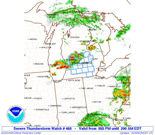
Severe Thunderstorm Watch Number 468
NWS Storm Prediction Center Norman OK
955 PM EDT Fri Aug 28 2020
The NWS Storm Prediction Center has issued a
* Severe Thunderstorm Watch for portions of
Lower Michigan
* Effective this Friday night and Saturday morning from 955 PM
until 200 AM EDT.
* Primary threats include...
Scattered damaging wind gusts to 70 mph possible
Isolated large hail events to 1.5 inches in diameter possible
A tornado or two possible
SUMMARY...Clusters of storms including the possibility of a
supercell or two will spread east-southeastward across the southern
half of Lower Michigan this evening, with isolated damaging winds
and some severe hail as the primary hazards.
The severe thunderstorm watch area is approximately along and 40
statute miles north and south of a line from 25 miles southwest of
Grand Rapids MI to 25 miles north northeast of Ann Arbor MI. For a
complete depiction of the watch see the associated watch outline
update (WOUS64 KWNS WOU8).
PRECAUTIONARY/PREPAREDNESS ACTIONS...
REMEMBER...A Severe Thunderstorm Watch means conditions are
favorable for severe thunderstorms in and close to the watch area.
Persons in these areas should be on the lookout for threatening
weather conditions and listen for later statements and possible
warnings. Severe thunderstorms can and occasionally do produce
tornadoes.
&&
AVIATION...A few severe thunderstorms with hail surface and aloft to
1.5 inches. Extreme turbulence and surface wind gusts to 60 knots. A
few cumulonimbi with maximum tops to 550. Mean storm motion vector
28020.
...Guyer
   SEL8

   URGENT - IMMEDIATE BROADCAST REQUESTED
   Severe Thunderstorm Watch Number 468
   NWS Storm Prediction Center Norman OK
   955 PM EDT Fri Aug 28 2020

   The NWS Storm Prediction Center has issued a

   * Severe Thunderstorm Watch for portions of
     Lower Michigan

   * Effective this Friday night and Saturday morning from 955 PM
     until 200 AM EDT.

   * Primary threats include...
     Scattered damaging wind gusts to 70 mph possible
     Isolated large hail events to 1.5 inches in diameter possible
     A tornado or two possible

   SUMMARY...Clusters of storms including the possibility of a
   supercell or two will spread east-southeastward across the southern
   half of Lower Michigan this evening, with isolated damaging winds
   and some severe hail as the primary hazards.

   The severe thunderstorm watch area is approximately along and 40
   statute miles north and south of a line from 25 miles southwest of
   Grand Rapids MI to 25 miles north northeast of Ann Arbor MI. For a
   complete depiction of the watch see the associated watch outline
   update (WOUS64 KWNS WOU8).

   PRECAUTIONARY/PREPAREDNESS ACTIONS...

   REMEMBER...A Severe Thunderstorm Watch means conditions are
   favorable for severe thunderstorms in and close to the watch area.
   Persons in these areas should be on the lookout for threatening
   weather conditions and listen for later statements and possible
   warnings. Severe thunderstorms can and occasionally do produce
   tornadoes.

   &&

   AVIATION...A few severe thunderstorms with hail surface and aloft to
   1.5 inches. Extreme turbulence and surface wind gusts to 60 knots. A
   few cumulonimbi with maximum tops to 550. Mean storm motion vector
   28020.

   ...Guyer
 Note:
The Aviation Watch (SAW) product is an approximation to the watch area.
The actual watch is depicted by the shaded areas.
Note:
The Aviation Watch (SAW) product is an approximation to the watch area.
The actual watch is depicted by the shaded areas.
   SAW8
   WW 468 SEVERE TSTM MI 290155Z - 290600Z
   AXIS..40 STATUTE MILES NORTH AND SOUTH OF LINE..
   25SW GRR/GRAND RAPIDS MI/ - 25NNE ARB/ANN ARBOR MI/
   ..AVIATION COORDS.. 35NM N/S /14NE PMM - 22NNW DXO/
   HAIL SURFACE AND ALOFT..1.5 INCHES. WIND GUSTS..60 KNOTS.
   MAX TOPS TO 550. MEAN STORM MOTION VECTOR 28020.

   LAT...LON 43208587 43138356 41988356 42048587

   THIS IS AN APPROXIMATION TO THE WATCH AREA.  FOR A
   COMPLETE DEPICTION OF THE WATCH SEE WOUS64 KWNS
   FOR WOU8.
Watch 468 Status Report Messages:
STATUS REPORT #2 ON WW 468

VALID 290455Z - 290540Z

SEVERE WEATHER THREAT CONTINUES RIGHT OF A LINE FROM 20 WNW AZO
TO 20 ESE LAN TO 15 NE FNT.

FOR ADDITIONAL INFORMATION SEE MESOSCALE DISCUSSION 1623

..GUYER..08/29/20

ATTN...WFO...GRR...DTX...

&&

STATUS REPORT FOR WS 468

SEVERE WEATHER THREAT CONTINUES FOR THE FOLLOWING AREAS

MIC025-045-049-065-075-077-091-093-161-290540-

MI
.    MICHIGAN COUNTIES INCLUDED ARE

CALHOUN 	     EATON		 GENESEE
INGHAM		     JACKSON		 KALAMAZOO
LENAWEE 	     LIVINGSTON 	 WASHTENAW
$$


THE WATCH STATUS MESSAGE IS FOR GUIDANCE PURPOSES ONLY.  PLEASE
REFER TO WATCH COUNTY NOTIFICATION STATEMENTS FOR OFFICIAL
INFORMATION ON COUNTIES...INDEPENDENT CITIES AND MARINE ZONES
CLEARED FROM SEVERE THUNDERSTORM AND TORNADO WATCHES.
$$

STATUS REPORT #1 ON WW 468

VALID 290345Z - 290440Z

SEVERE WEATHER THREAT CONTINUES RIGHT OF A LINE FROM 35 SSW MKG
TO 20 SW GRR TO 20 N AZO TO 25 WSW LAN TO 10 NNE LAN TO 25 SSW
MBS TO 25 NNE FNT.

FOR ADDITIONAL INFORMATION SEE MESOSCALE DISCUSSION 1623

..JEWELL..08/29/20

ATTN...WFO...GRR...DTX...

&&

STATUS REPORT FOR WS 468

SEVERE WEATHER THREAT CONTINUES FOR THE FOLLOWING AREAS

MIC005-015-025-037-045-049-065-075-077-091-093-155-161-290440-

MI
.    MICHIGAN COUNTIES INCLUDED ARE

ALLEGAN 	     BARRY		 CALHOUN
CLINTON 	     EATON		 GENESEE
INGHAM		     JACKSON		 KALAMAZOO
LENAWEE 	     LIVINGSTON 	 SHIAWASSEE
WASHTENAW
$$


THE WATCH STATUS MESSAGE IS FOR GUIDANCE PURPOSES ONLY.  PLEASE
REFER TO WATCH COUNTY NOTIFICATION STATEMENTS FOR OFFICIAL
INFORMATION ON COUNTIES...INDEPENDENT CITIES AND MARINE ZONES
CLEARED FROM SEVERE THUNDERSTORM AND TORNADO WATCHES.
$$
Note:
Click for Complete Product Text.
Tornadoes
Probability of 2 or more tornadoes
|
Low (20%)
|
Probability of 1 or more strong (EF2-EF5) tornadoes
|
Low (5%)
|
Wind
Probability of 10 or more severe wind events
|
Mod (50%)
|
Probability of 1 or more wind events > 65 knots
|
Low (10%)
|
Hail
Probability of 10 or more severe hail events
|
Mod (30%)
|
Probability of 1 or more hailstones > 2 inches
|
Low (20%)
|
Combined Severe Hail/Wind
Probability of 6 or more combined severe hail/wind events
|
High (70%)
|
For each watch, probabilities for particular events inside the watch
(listed above in each table) are determined by the issuing forecaster.
The "Low" category contains probability values ranging from less than 2%
to 20% (EF2-EF5 tornadoes), less than 5% to 20% (all other probabilities),
"Moderate" from 30% to 60%, and "High" from 70% to greater than 95%.
High values are bolded and lighter in color to provide awareness of
an increased threat for a particular event.


 @NWSSPC


