Note:
The expiration time in the watch graphic is amended if the watch is
replaced, cancelled or extended.
Note:
Note:
The expiration time in the watch graphic is amended if the watch is
replaced, cancelled or extended.
Note: Click for
Watch Status Reports.
SEL7
URGENT - IMMEDIATE BROADCAST REQUESTED
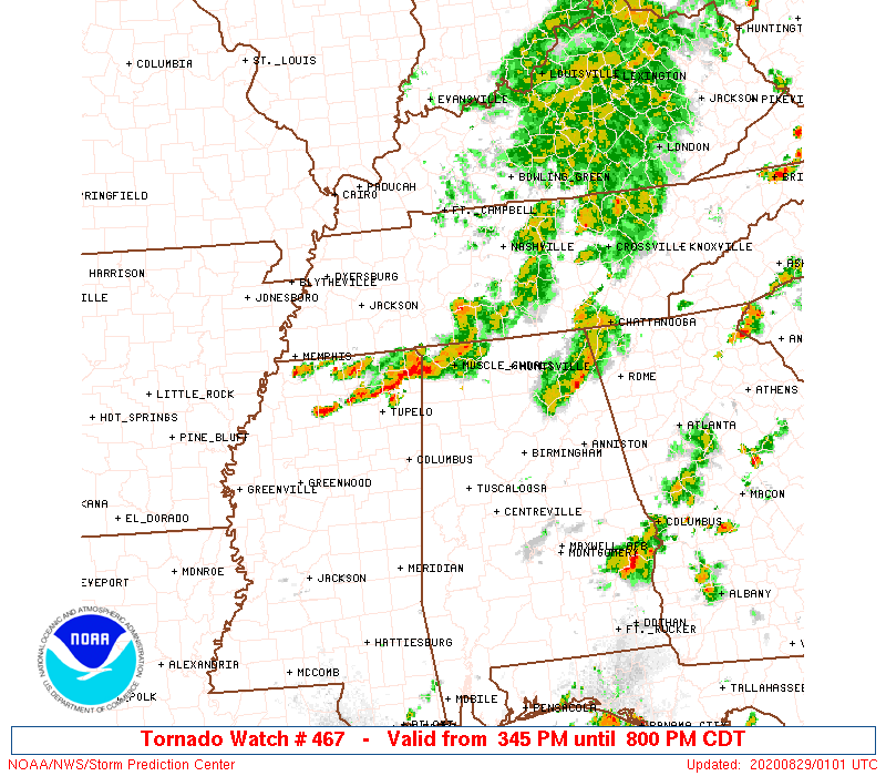
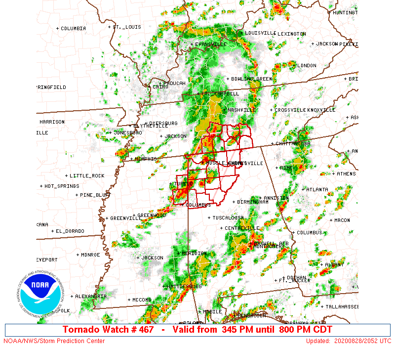
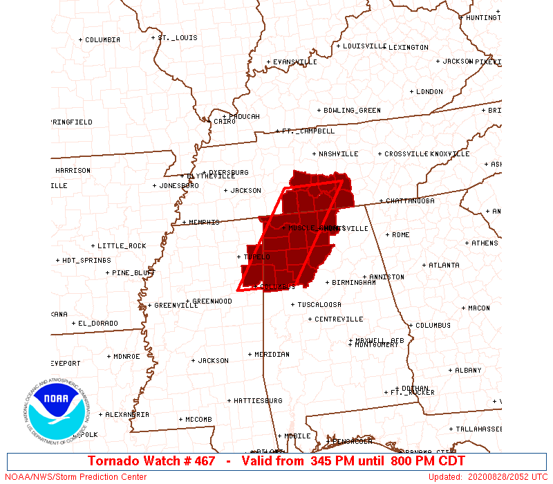
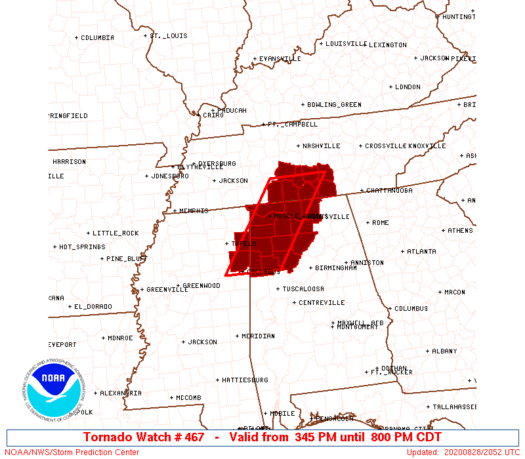
Tornado Watch Number 467
NWS Storm Prediction Center Norman OK
345 PM CDT Fri Aug 28 2020
The NWS Storm Prediction Center has issued a
* Tornado Watch for portions of
Northwest and north-central Alabama
Far northeast Mississippi
Southern middle Tennessee
* Effective this Friday afternoon and evening from 345 PM until
800 PM CDT.
* Primary threats include...
A couple tornadoes possible
Isolated damaging wind gusts to 65 mph possible
SUMMARY...Lingering clusters may still pose a risk for a couple
brief tornadoes and locally damaging winds into early evening.
The tornado watch area is approximately along and 40 statute miles
east and west of a line from 60 miles north of Huntsville AL to 85
miles south southwest of Muscle Shoals AL. For a complete depiction
of the watch see the associated watch outline update (WOUS64 KWNS
WOU7).
PRECAUTIONARY/PREPAREDNESS ACTIONS...
REMEMBER...A Tornado Watch means conditions are favorable for
tornadoes and severe thunderstorms in and close to the watch
area. Persons in these areas should be on the lookout for
threatening weather conditions and listen for later statements
and possible warnings.
&&
OTHER WATCH INFORMATION...This tornado watch replaces tornado
watch number 463...tornado watch number 465. Watch number 463 465
will not be in effect after 345 PM CDT. CONTINUE...WW 464...WW
466...
AVIATION...Tornadoes and a few severe thunderstorms with hail
surface and aloft to 1 inch. Extreme turbulence and surface wind
gusts to 55 knots. A few cumulonimbi with maximum tops to 450. Mean
storm motion vector 23030.
...Grams
 Note:
The Aviation Watch (SAW) product is an approximation to the watch area.
The actual watch is depicted by the shaded areas.
Note:
The Aviation Watch (SAW) product is an approximation to the watch area.
The actual watch is depicted by the shaded areas.
   SAW7
   WW 467 TORNADO AL MS TN 282045Z - 290100Z
   AXIS..40 STATUTE MILES EAST AND WEST OF LINE..
   60N HSV/HUNTSVILLE AL/ - 85SSW MSL/MUSCLE SHOALS AL/
   ..AVIATION COORDS.. 35NM E/W /38S BNA - 19ENE IGB/
   HAIL SURFACE AND ALOFT..1 INCH. WIND GUSTS..55 KNOTS.
   MAX TOPS TO 450. MEAN STORM MOTION VECTOR 23030.

   REPLACES WW 463..AL MS TN
   REPLACES WW 465..KY TN

   LAT...LON 35528607 33618749 33618888 35528749

   THIS IS AN APPROXIMATION TO THE WATCH AREA.  FOR A
   COMPLETE DEPICTION OF THE WATCH SEE WOUS64 KWNS
   FOR WOU7.
Watch 467 Status Report Messages:
STATUS REPORT #1 ON WW 467

VALID 282055Z - 282200Z

THE SEVERE WEATHER THREAT CONTINUES ACROSS THE ENTIRE WATCH AREA.

..SMITH..08/28/20

ATTN...WFO...HUN...BMX...MEG...OHX...

&&

STATUS REPORT FOR WT 467

SEVERE WEATHER THREAT CONTINUES FOR THE FOLLOWING AREAS

ALC033-043-057-059-075-077-079-083-089-093-103-127-133-282200-

AL
.    ALABAMA COUNTIES INCLUDED ARE

COLBERT 	     CULLMAN		 FAYETTE
FRANKLIN	     LAMAR		 LAUDERDALE
LAWRENCE	     LIMESTONE		 MADISON
MARION		     MORGAN		 WALKER
WINSTON
$$


MSC057-095-282200-

MS
.    MISSISSIPPI COUNTIES INCLUDED ARE

ITAWAMBA	     MONROE
$$


TNC003-031-051-055-099-103-117-119-127-282200-

TN
.    TENNESSEE COUNTIES INCLUDED ARE

BEDFORD 	     COFFEE		 FRANKLIN
GILES		     LAWRENCE		 LINCOLN
MARSHALL	     MAURY		 MOORE
$$


THE WATCH STATUS MESSAGE IS FOR GUIDANCE PURPOSES ONLY.  PLEASE
REFER TO WATCH COUNTY NOTIFICATION STATEMENTS FOR OFFICIAL
INFORMATION ON COUNTIES...INDEPENDENT CITIES AND MARINE ZONES
CLEARED FROM SEVERE THUNDERSTORM AND TORNADO WATCHES.
$$
Note:
Click for Complete Product Text.
Tornadoes
Probability of 2 or more tornadoes
|
Mod (30%)
|
Probability of 1 or more strong (EF2-EF5) tornadoes
|
Low (10%)
|
Wind
Probability of 10 or more severe wind events
|
Mod (30%)
|
Probability of 1 or more wind events > 65 knots
|
Low (10%)
|
Hail
Probability of 10 or more severe hail events
|
Low (<5%)
|
Probability of 1 or more hailstones > 2 inches
|
Low (<5%)
|
Combined Severe Hail/Wind
Probability of 6 or more combined severe hail/wind events
|
Mod (40%)
|
For each watch, probabilities for particular events inside the watch
(listed above in each table) are determined by the issuing forecaster.
The "Low" category contains probability values ranging from less than 2%
to 20% (EF2-EF5 tornadoes), less than 5% to 20% (all other probabilities),
"Moderate" from 30% to 60%, and "High" from 70% to greater than 95%.
High values are bolded and lighter in color to provide awareness of
an increased threat for a particular event.


 @NWSSPC