 Note:
The expiration time in the watch graphic is amended if the watch is
replaced, cancelled or extended.
Note:
Note:
The expiration time in the watch graphic is amended if the watch is
replaced, cancelled or extended.
Note: Click for
Watch Status Reports.
SEL8
URGENT - IMMEDIATE BROADCAST REQUESTED
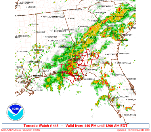
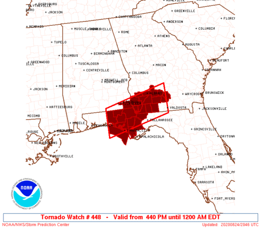
Tornado Watch Number 448
NWS Storm Prediction Center Norman OK
440 PM EDT Mon Aug 24 2020
The NWS Storm Prediction Center has issued a
* Tornado Watch for portions of
Far Southeast Alabama
Florida Panhandle
Southwest Georgia
Coastal Waters
* Effective this Monday afternoon from 440 PM until Midnight EDT.
* Primary threats include...
A couple tornadoes possible
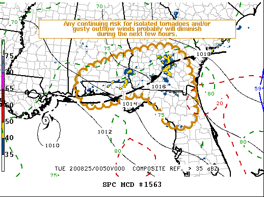
SUMMARY...A moist air mass and moderately strong low-level shear
will conducive for transient supercells capable of a tornado late
this afternoon and evening.
The tornado watch area is approximately along and 45 statute miles
north and south of a line from 45 miles west northwest of Panama
City FL to 30 miles north of Valdosta GA. For a complete depiction
of the watch see the associated watch outline update (WOUS64 KWNS
WOU8).
PRECAUTIONARY/PREPAREDNESS ACTIONS...
REMEMBER...A Tornado Watch means conditions are favorable for
tornadoes and severe thunderstorms in and close to the watch
area. Persons in these areas should be on the lookout for
threatening weather conditions and listen for later statements
and possible warnings.
&&
AVIATION...Tornadoes and a few severe thunderstorms with hail
surface and aloft to 0 inches. Extreme turbulence and surface wind
gusts to 60 knots. A few cumulonimbi with maximum tops to 500. Mean
storm motion vector 14020.
...Guyer
 Note:
The Aviation Watch (SAW) product is an approximation to the watch area.
The actual watch is depicted by the shaded areas.
Note:
The Aviation Watch (SAW) product is an approximation to the watch area.
The actual watch is depicted by the shaded areas.
   SAW8
   WW 448 TORNADO AL FL GA CW 242040Z - 250400Z
   AXIS..45 STATUTE MILES NORTH AND SOUTH OF LINE..
   45WNW PFN/PANAMA CITY FL/ - 30N VLD/VALDOSTA GA/
   ..AVIATION COORDS.. 40NM N/S /27SE CEW - 44WSW AMG/
   WIND GUSTS..60 KNOTS.
   MAX TOPS TO 500.MEAN STORM MOTION VECTOR 14020.

   LAT...LON 31128638 31878328 30568328 29828638

   THIS IS AN APPROXIMATION TO THE WATCH AREA.  FOR A
   COMPLETE DEPICTION OF THE WATCH SEE WOUS64 KWNS
   FOR WOU8.
Watch 448 Status Report Messages:
STATUS REPORT #7 ON WW 448

VALID 250330Z - 250400Z

SEVERE WEATHER THREAT CONTINUES RIGHT OF A LINE FROM 15 NNE CEW
TO 35 ENE CEW TO 20 SSW PFN.

REMAINING VALID PORTION OF WW COULD BE LOCALLY EXTENDED IN TIME
FOR AN HOUR OR TWO, OTHERWISE WW 448 MY BE ALLOWED TO EXPIRE AT
25/04Z.

..KERR..08/25/20

ATTN...WFO...TAE...

&&

STATUS REPORT FOR WT 448

SEVERE WEATHER THREAT CONTINUES FOR THE FOLLOWING AREAS

FLC131-250400-

FL
.    FLORIDA COUNTIES INCLUDED ARE

WALTON
$$


GMZ750-250400-

CW

.    ADJACENT COASTAL WATERS INCLUDED ARE

COASTAL WATERS FROM OKALOOSA-WALTON COUNTY LINE TO MEXICO BEACH
OUT 20 NM

$$
THE WATCH STATUS MESSAGE IS FOR GUIDANCE PURPOSES ONLY.  PLEASE
REFER TO WATCH COUNTY NOTIFICATION STATEMENTS FOR OFFICIAL
INFORMATION ON COUNTIES...INDEPENDENT CITIES AND MARINE ZONES
CLEARED FROM SEVERE THUNDERSTORM AND TORNADO WATCHES.
$$

STATUS REPORT #6 ON WW 448

VALID 250325Z - 250440Z

SEVERE WEATHER THREAT CONTINUES RIGHT OF A LINE FROM 15 NNE CEW
TO 35 ENE CEW TO 20 SSW PFN.

..KERR..08/25/20

ATTN...WFO...TAE...

&&

STATUS REPORT FOR WT 448

SEVERE WEATHER THREAT CONTINUES FOR THE FOLLOWING AREAS

FLC131-250440-

FL
.    FLORIDA COUNTIES INCLUDED ARE

WALTON
$$


GMZ750-250440-

CW

.    ADJACENT COASTAL WATERS INCLUDED ARE

COASTAL WATERS FROM OKALOOSA-WALTON COUNTY LINE TO MEXICO BEACH
OUT 20 NM

$$
THE WATCH STATUS MESSAGE IS FOR GUIDANCE PURPOSES ONLY.  PLEASE
REFER TO WATCH COUNTY NOTIFICATION STATEMENTS FOR OFFICIAL
INFORMATION ON COUNTIES...INDEPENDENT CITIES AND MARINE ZONES
CLEARED FROM SEVERE THUNDERSTORM AND TORNADO WATCHES.
$$

STATUS REPORT #5 ON WW 448

VALID 250230Z - 250340Z

SEVERE WEATHER THREAT CONTINUES RIGHT OF A LINE FROM 20 W ABY TO
15 SW MAI TO 20 ESE PFN.

..KERR..08/25/20

ATTN...WFO...TAE...

&&

STATUS REPORT FOR WT 448

SEVERE WEATHER THREAT CONTINUES FOR THE FOLLOWING AREAS

ALC069-250340-

AL
.    ALABAMA COUNTIES INCLUDED ARE

HOUSTON
$$


FLC059-131-133-250340-

FL
.    FLORIDA COUNTIES INCLUDED ARE

HOLMES		     WALTON		 WASHINGTON
$$


GAC037-099-250340-

GA
.    GEORGIA COUNTIES INCLUDED ARE

CALHOUN 	     EARLY
$$


GMZ750-250340-

CW

.    ADJACENT COASTAL WATERS INCLUDED ARE

COASTAL WATERS FROM OKALOOSA-WALTON COUNTY LINE TO MEXICO BEACH
OUT 20 NM

$$
THE WATCH STATUS MESSAGE IS FOR GUIDANCE PURPOSES ONLY.  PLEASE
REFER TO WATCH COUNTY NOTIFICATION STATEMENTS FOR OFFICIAL
INFORMATION ON COUNTIES...INDEPENDENT CITIES AND MARINE ZONES
CLEARED FROM SEVERE THUNDERSTORM AND TORNADO WATCHES.
$$

STATUS REPORT #4 ON WW 448

VALID 250150Z - 250240Z

SEVERE WEATHER THREAT CONTINUES RIGHT OF A LINE FROM 30 ENE MGR
TO 30 N PFN TO 15 SSE PFN.

..KERR..08/25/20

ATTN...WFO...TAE...

&&

STATUS REPORT FOR WT 448

SEVERE WEATHER THREAT CONTINUES FOR THE FOLLOWING AREAS

ALC069-250240-

AL
.    ALABAMA COUNTIES INCLUDED ARE

HOUSTON
$$


FLC039-059-063-131-133-250240-

FL
.    FLORIDA COUNTIES INCLUDED ARE

GADSDEN 	     HOLMES		 JACKSON
WALTON		     WASHINGTON
$$


GAC007-037-095-099-201-205-277-321-250240-

GA
.    GEORGIA COUNTIES INCLUDED ARE

BAKER		     CALHOUN		 DOUGHERTY
EARLY		     MILLER		 MITCHELL
TIFT		     WORTH
$$


GMZ750-250240-

CW

.    ADJACENT COASTAL WATERS INCLUDED ARE

COASTAL WATERS FROM OKALOOSA-WALTON COUNTY LINE TO MEXICO BEACH
OUT 20 NM

$$
THE WATCH STATUS MESSAGE IS FOR GUIDANCE PURPOSES ONLY.  PLEASE
REFER TO WATCH COUNTY NOTIFICATION STATEMENTS FOR OFFICIAL
INFORMATION ON COUNTIES...INDEPENDENT CITIES AND MARINE ZONES
CLEARED FROM SEVERE THUNDERSTORM AND TORNADO WATCHES.
$$

STATUS REPORT #3 ON WW 448

VALID 250115Z - 250240Z

SEVERE WEATHER THREAT CONTINUES RIGHT OF A LINE FROM 10 N VLD TO
25 S MAI TO 25 ESE PFN.

..KERR..08/25/20

ATTN...WFO...TAE...

&&

STATUS REPORT FOR WT 448

SEVERE WEATHER THREAT CONTINUES FOR THE FOLLOWING AREAS

ALC069-250240-

AL
.    ALABAMA COUNTIES INCLUDED ARE

HOUSTON
$$


FLC005-039-059-063-131-133-250240-

FL
.    FLORIDA COUNTIES INCLUDED ARE

BAY		     GADSDEN		 HOLMES
JACKSON 	     WALTON		 WASHINGTON
$$


GAC007-019-037-071-075-087-095-099-131-201-205-253-275-277-321-
250240-

GA
.    GEORGIA COUNTIES INCLUDED ARE

BAKER		     BERRIEN		 CALHOUN
COLQUITT	     COOK		 DECATUR
DOUGHERTY	     EARLY		 GRADY
MILLER		     MITCHELL		 SEMINOLE
THOMAS		     TIFT		 WORTH
$$


GMZ750-250240-

CW

.    ADJACENT COASTAL WATERS INCLUDED ARE

COASTAL WATERS FROM OKALOOSA-WALTON COUNTY LINE TO MEXICO BEACH
OUT 20 NM

$$
THE WATCH STATUS MESSAGE IS FOR GUIDANCE PURPOSES ONLY.  PLEASE
REFER TO WATCH COUNTY NOTIFICATION STATEMENTS FOR OFFICIAL
INFORMATION ON COUNTIES...INDEPENDENT CITIES AND MARINE ZONES
CLEARED FROM SEVERE THUNDERSTORM AND TORNADO WATCHES.
$$

STATUS REPORT #2 ON WW 448

VALID 242330Z - 250040Z

THE SEVERE WEATHER THREAT CONTINUES ACROSS THE ENTIRE WATCH AREA.

..KERR..08/24/20

ATTN...WFO...TAE...

&&

STATUS REPORT FOR WT 448

SEVERE WEATHER THREAT CONTINUES FOR THE FOLLOWING AREAS

ALC069-250040-

AL
.    ALABAMA COUNTIES INCLUDED ARE

HOUSTON
$$


FLC005-013-039-045-059-063-077-131-133-250040-

FL
.    FLORIDA COUNTIES INCLUDED ARE

BAY		     CALHOUN		 GADSDEN
GULF		     HOLMES		 JACKSON
LIBERTY 	     WALTON		 WASHINGTON
$$


GAC007-019-037-071-075-087-095-099-131-201-205-253-275-277-321-
250040-

GA
.    GEORGIA COUNTIES INCLUDED ARE

BAKER		     BERRIEN		 CALHOUN
COLQUITT	     COOK		 DECATUR
DOUGHERTY	     EARLY		 GRADY
MILLER		     MITCHELL		 SEMINOLE
THOMAS		     TIFT		 WORTH
$$


GMZ750-250040-

CW

.    ADJACENT COASTAL WATERS INCLUDED ARE

COASTAL WATERS FROM OKALOOSA-WALTON COUNTY LINE TO MEXICO BEACH
OUT 20 NM

$$
THE WATCH STATUS MESSAGE IS FOR GUIDANCE PURPOSES ONLY.  PLEASE
REFER TO WATCH COUNTY NOTIFICATION STATEMENTS FOR OFFICIAL
INFORMATION ON COUNTIES...INDEPENDENT CITIES AND MARINE ZONES
CLEARED FROM SEVERE THUNDERSTORM AND TORNADO WATCHES.
$$

STATUS REPORT #1 ON WW 448

VALID 242225Z - 242340Z

THE SEVERE WEATHER THREAT CONTINUES ACROSS THE ENTIRE WATCH AREA.

..KERR..08/24/20

ATTN...WFO...TAE...

&&

STATUS REPORT FOR WT 448

SEVERE WEATHER THREAT CONTINUES FOR THE FOLLOWING AREAS

ALC069-242340-

AL
.    ALABAMA COUNTIES INCLUDED ARE

HOUSTON
$$


FLC005-013-039-045-059-063-077-131-133-242340-

FL
.    FLORIDA COUNTIES INCLUDED ARE

BAY		     CALHOUN		 GADSDEN
GULF		     HOLMES		 JACKSON
LIBERTY 	     WALTON		 WASHINGTON
$$


GAC007-019-037-071-075-087-095-099-131-201-205-253-275-277-321-
242340-

GA
.    GEORGIA COUNTIES INCLUDED ARE

BAKER		     BERRIEN		 CALHOUN
COLQUITT	     COOK		 DECATUR
DOUGHERTY	     EARLY		 GRADY
MILLER		     MITCHELL		 SEMINOLE
THOMAS		     TIFT		 WORTH
$$


GMZ750-242340-

CW

.    ADJACENT COASTAL WATERS INCLUDED ARE

COASTAL WATERS FROM OKALOOSA-WALTON COUNTY LINE TO MEXICO BEACH
OUT 20 NM

$$
THE WATCH STATUS MESSAGE IS FOR GUIDANCE PURPOSES ONLY.  PLEASE
REFER TO WATCH COUNTY NOTIFICATION STATEMENTS FOR OFFICIAL
INFORMATION ON COUNTIES...INDEPENDENT CITIES AND MARINE ZONES
CLEARED FROM SEVERE THUNDERSTORM AND TORNADO WATCHES.
$$
Note:
Click for Complete Product Text.
Tornadoes
Probability of 2 or more tornadoes
|
Mod (40%)
|
Probability of 1 or more strong (EF2-EF5) tornadoes
|
Low (10%)
|
Wind
Probability of 10 or more severe wind events
|
Low (<5%)
|
Probability of 1 or more wind events > 65 knots
|
Low (<5%)
|
Hail
Probability of 10 or more severe hail events
|
Low (<5%)
|
Probability of 1 or more hailstones > 2 inches
|
Low (<5%)
|
Combined Severe Hail/Wind
Probability of 6 or more combined severe hail/wind events
|
Low (20%)
|
For each watch, probabilities for particular events inside the watch
(listed above in each table) are determined by the issuing forecaster.
The "Low" category contains probability values ranging from less than 2%
to 20% (EF2-EF5 tornadoes), less than 5% to 20% (all other probabilities),
"Moderate" from 30% to 60%, and "High" from 70% to greater than 95%.
High values are bolded and lighter in color to provide awareness of
an increased threat for a particular event.


 @NWSSPC