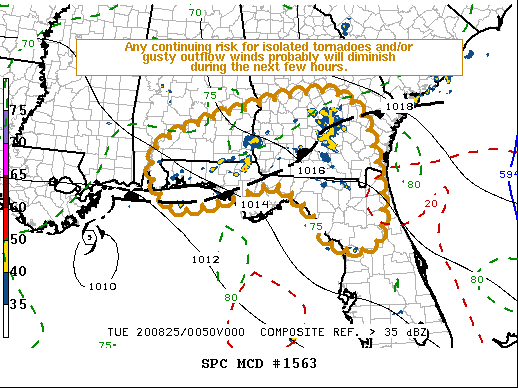
   Mesoscale Discussion 1563
   NWS Storm Prediction Center Norman OK
   0805 PM CDT Mon Aug 24 2020

   Areas affected...Parts of the Florida Panhandle and adjacent
   southern Alabama

   Concerning...Tornado Watch 448...

   Valid 250105Z - 250230Z

   The severe weather threat for Tornado Watch 448 continues.

   SUMMARY...The potential for isolated tornadoes and/or gusty outflow
   winds probably will gradually diminish during the next few hours.  A
   new watch is not anticipated.

   DISCUSSION...The low-level circulation center of Marco is now
   south/southwest of Boothville LA, while increasingly sheared
   mid-level remnants continue to migrate inland of the northeastern
   Gulf coast, across southeastern Alabama, toward west central
   Georgia.  This is occurring around the western periphery of a
   prominent western Atlantic subtropical ridge.  A substantive
   lower/mid tropospheric height gradient along the southwestern
   periphery of this ridging is maintaining moderate (30+ kt)
   southeasterly low-level flow across much of the Florida Peninsula
   into southern Georgia/Alabama, but models suggest that this will
   gradually shift westward and weaken overnight.

   Weak low-level warm advection and associated lift of tropical
   moisture supportive of sizable CAPE (1000-2000+ J/kg) has maintained
   vigorous convective development.  Across much of the Florida
   Panhandle, this has generally remain focused to the north of a zone
   of stronger differential surface heating, above at least a shallow
   rain-cooled surface-based air mass.

   However, as indicated in the 25/00Z sounding from Tallahassee,
   hodographs within the elevated inflow layer are modestly large,
   clockwise curved and supportive of updraft rotation.  Sustained
   updraft rotation has been observed in at least a couple of storms
   spreading across the Interstate 10 corridor west of Tallahassee, but
   the lingering presence of the stable surface layer suggests limited
   potential for tornadic development.

   These storms, and the gusty outflow dominant boundary-layer based
   storms, which spread across northern Florida into southern Georgia,
   probably will begin to wane with boundary-layer cooling due to loss
   of daytime heating and convective outflow.

   ..Kerr.. 08/25/2020

   ...Please see www.spc.noaa.gov for graphic product...

   ATTN...WFO...CHS...TBW...JAX...FFC...TAE...BMX...MOB...

   LAT...LON   31248773 32288519 32618288 31608191 29268172 29058289
               29958363 30508453 30128584 29928730 31248773
|


 @NWSSPC