Note:
The expiration time in the watch graphic is amended if the watch is
replaced, cancelled or extended.
Note:
Note:
The expiration time in the watch graphic is amended if the watch is
replaced, cancelled or extended.
Note: Click for
Watch Status Reports.
SEL9
URGENT - IMMEDIATE BROADCAST REQUESTED
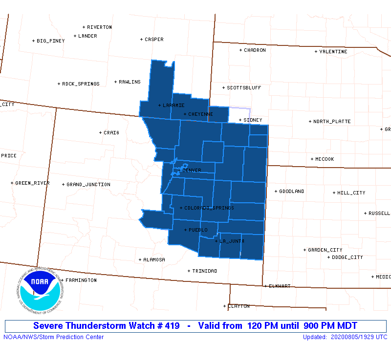
Severe Thunderstorm Watch Number 419
NWS Storm Prediction Center Norman OK
120 PM MDT Wed Aug 5 2020
The NWS Storm Prediction Center has issued a
* Severe Thunderstorm Watch for portions of
eastern Colorado
Nebraska Panhandle
southeastern Wyoming
* Effective this Wednesday afternoon and evening from 120 PM
until 900 PM MDT.
* Primary threats include...
Scattered large hail and isolated very large hail events to 2
inches in diameter possible
Scattered damaging wind gusts to 70 mph possible
A tornado or two possible
SUMMARY...Thunderstorms forming near the Front Range will intensify
this afternoon, while spreading southeastward off the higher
terrain. A couple of supercells are possible, along with one or two
growing clusters of storms, which may pose a risk for severe wind,
in addition to large hail.
The severe thunderstorm watch area is approximately along and 70
statute miles east and west of a line from 45 miles east northeast
of Cheyenne WY to 55 miles southeast of Colorado Springs CO. For a
complete depiction of the watch see the associated watch outline
update (WOUS64 KWNS WOU9).
PRECAUTIONARY/PREPAREDNESS ACTIONS...
REMEMBER...A Severe Thunderstorm Watch means conditions are
favorable for severe thunderstorms in and close to the watch area.
Persons in these areas should be on the lookout for threatening
weather conditions and listen for later statements and possible
warnings. Severe thunderstorms can and occasionally do produce
tornadoes.
&&
AVIATION...A few severe thunderstorms with hail surface and aloft to
2 inches. Extreme turbulence and surface wind gusts to 60 knots. A
few cumulonimbi with maximum tops to 500. Mean storm motion vector
34015.
...Kerr

   SEL9

   URGENT - IMMEDIATE BROADCAST REQUESTED
   Severe Thunderstorm Watch Number 419
   NWS Storm Prediction Center Norman OK
   120 PM MDT Wed Aug 5 2020

   The NWS Storm Prediction Center has issued a

   * Severe Thunderstorm Watch for portions of
     eastern Colorado
     Nebraska Panhandle
     southeastern Wyoming

   * Effective this Wednesday afternoon and evening from 120 PM
     until 900 PM MDT.

   * Primary threats include...
     Scattered large hail and isolated very large hail events to 2
       inches in diameter possible
     Scattered damaging wind gusts to 70 mph possible
     A tornado or two possible

   SUMMARY...Thunderstorms forming near the Front Range will intensify
   this afternoon, while spreading southeastward off the higher
   terrain.  A couple of supercells are possible, along with one or two
   growing clusters of storms, which may pose a risk for severe wind,
   in addition to large hail.

   The severe thunderstorm watch area is approximately along and 70
   statute miles east and west of a line from 45 miles east northeast
   of Cheyenne WY to 55 miles southeast of Colorado Springs CO. For a
   complete depiction of the watch see the associated watch outline
   update (WOUS64 KWNS WOU9).

   PRECAUTIONARY/PREPAREDNESS ACTIONS...

   REMEMBER...A Severe Thunderstorm Watch means conditions are
   favorable for severe thunderstorms in and close to the watch area.
   Persons in these areas should be on the lookout for threatening
   weather conditions and listen for later statements and possible
   warnings. Severe thunderstorms can and occasionally do produce
   tornadoes.

   &&

   AVIATION...A few severe thunderstorms with hail surface and aloft to
   2 inches. Extreme turbulence and surface wind gusts to 60 knots. A
   few cumulonimbi with maximum tops to 500. Mean storm motion vector
   34015.

   ...Kerr
 Note:
The Aviation Watch (SAW) product is an approximation to the watch area.
The actual watch is depicted by the shaded areas.
Note:
The Aviation Watch (SAW) product is an approximation to the watch area.
The actual watch is depicted by the shaded areas.
   SAW9
   WW 419 SEVERE TSTM CO NE WY 051920Z - 060300Z
   AXIS..70 STATUTE MILES EAST AND WEST OF LINE..
   45ENE CYS/CHEYENNE WY/ - 55SE COS/COLORADO SPRINGS CO/
   ..AVIATION COORDS.. 60NM E/W /36ENE CYS - 20E PUB/
   HAIL SURFACE AND ALOFT..2 INCHES. WIND GUSTS..60 KNOTS.
   MAX TOPS TO 500. MEAN STORM MOTION VECTOR 34015.

   LAT...LON 41390267 38250271 38250529 41390537

   THIS IS AN APPROXIMATION TO THE WATCH AREA.  FOR A
   COMPLETE DEPICTION OF THE WATCH SEE WOUS64 KWNS
   FOR WOU9.
Watch 419 Status Report Messages:
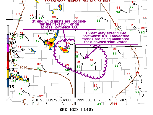
STATUS REPORT #2 ON WW 419

VALID 052340Z - 060040Z

SEVERE WEATHER THREAT CONTINUES RIGHT OF A LINE FROM 50 WNW COS
TO 40 W AKO TO 30 SSE LAR.

FOR ADDITIONAL INFORMATION SEE MESOSCALE DISCUSSION 1408

..MOSIER..08/05/20

ATTN...WFO...BOU...PUB...GLD...CYS...

&&

STATUS REPORT FOR WS 419

SEVERE WEATHER THREAT CONTINUES FOR THE FOLLOWING AREAS

COC001-005-011-017-025-035-039-041-043-061-063-073-075-087-089-
095-099-101-115-119-121-125-060040-

CO
.    COLORADO COUNTIES INCLUDED ARE

ADAMS		     ARAPAHOE		 BENT
CHEYENNE	     CROWLEY		 DOUGLAS
ELBERT		     EL PASO		 FREMONT
KIOWA		     KIT CARSON 	 LINCOLN
LOGAN		     MORGAN		 OTERO
PHILLIPS	     PROWERS		 PUEBLO
SEDGWICK	     TELLER		 WASHINGTON
YUMA
$$


NEC007-013-033-105-123-157-165-060040-

NE
.    NEBRASKA COUNTIES INCLUDED ARE

BANNER		     BOX BUTTE		 CHEYENNE
KIMBALL 	     MORRILL		 SCOTTS BLUFF
SIOUX
$$


WYC001-015-021-060040-

WY
.    WYOMING COUNTIES INCLUDED ARE

ALBANY		     GOSHEN		 LARAMIE
$$


THE WATCH STATUS MESSAGE IS FOR GUIDANCE PURPOSES ONLY.  PLEASE
REFER TO WATCH COUNTY NOTIFICATION STATEMENTS FOR OFFICIAL
INFORMATION ON COUNTIES...INDEPENDENT CITIES AND MARINE ZONES
CLEARED FROM SEVERE THUNDERSTORM AND TORNADO WATCHES.
$$

STATUS REPORT #1 ON WW 419

VALID 052030Z - 052140Z

THE SEVERE WEATHER THREAT CONTINUES ACROSS THE ENTIRE WATCH AREA.

..COOK..08/05/20

ATTN...WFO...BOU...PUB...GLD...CYS...

&&

STATUS REPORT FOR WS 419

SEVERE WEATHER THREAT CONTINUES FOR THE FOLLOWING AREAS

COC001-005-011-013-014-017-025-031-035-039-041-043-059-061-063-
069-073-075-087-089-095-099-101-115-119-121-123-125-052140-

CO
.    COLORADO COUNTIES INCLUDED ARE

ADAMS		     ARAPAHOE		 BENT
BOULDER 	     BROOMFIELD 	 CHEYENNE
CROWLEY 	     DENVER		 DOUGLAS
ELBERT		     EL PASO		 FREMONT
JEFFERSON	     KIOWA		 KIT CARSON
LARIMER 	     LINCOLN		 LOGAN
MORGAN		     OTERO		 PHILLIPS
PROWERS 	     PUEBLO		 SEDGWICK
TELLER		     WASHINGTON 	 WELD
YUMA
$$


NEC105-052140-

NE
.    NEBRASKA COUNTIES INCLUDED ARE

KIMBALL
$$


WYC001-021-052140-

WY
.    WYOMING COUNTIES INCLUDED ARE

ALBANY		     LARAMIE
$$


THE WATCH STATUS MESSAGE IS FOR GUIDANCE PURPOSES ONLY.  PLEASE
REFER TO WATCH COUNTY NOTIFICATION STATEMENTS FOR OFFICIAL
INFORMATION ON COUNTIES...INDEPENDENT CITIES AND MARINE ZONES
CLEARED FROM SEVERE THUNDERSTORM AND TORNADO WATCHES.
$$
Note:
Click for Complete Product Text.
Tornadoes
Probability of 2 or more tornadoes
|
Low (20%)
|
Probability of 1 or more strong (EF2-EF5) tornadoes
|
Low (<2%)
|
Wind
Probability of 10 or more severe wind events
|
Mod (40%)
|
Probability of 1 or more wind events > 65 knots
|
Low (20%)
|
Hail
Probability of 10 or more severe hail events
|
Mod (40%)
|
Probability of 1 or more hailstones > 2 inches
|
Mod (40%)
|
Combined Severe Hail/Wind
Probability of 6 or more combined severe hail/wind events
|
High (70%)
|
For each watch, probabilities for particular events inside the watch
(listed above in each table) are determined by the issuing forecaster.
The "Low" category contains probability values ranging from less than 2%
to 20% (EF2-EF5 tornadoes), less than 5% to 20% (all other probabilities),
"Moderate" from 30% to 60%, and "High" from 70% to greater than 95%.
High values are bolded and lighter in color to provide awareness of
an increased threat for a particular event.


 @NWSSPC