Note:
The expiration time in the watch graphic is amended if the watch is
replaced, cancelled or extended.
Note:
Note:
The expiration time in the watch graphic is amended if the watch is
replaced, cancelled or extended.
Note: Click for
Watch Status Reports.
SEL5
URGENT - IMMEDIATE BROADCAST REQUESTED
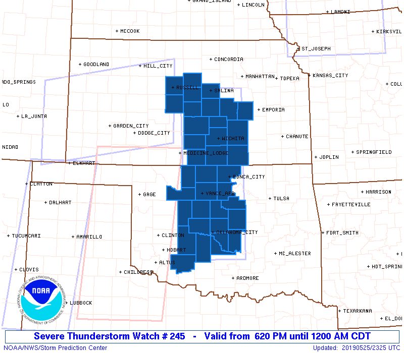
Severe Thunderstorm Watch Number 245
NWS Storm Prediction Center Norman OK
620 PM CDT Sat May 25 2019
The NWS Storm Prediction Center has issued a
* Severe Thunderstorm Watch for portions of
Central Kansas
Central Oklahoma
* Effective this Saturday night from 620 PM until Midnight CDT.
* Primary threats include...
Scattered damaging wind gusts to 70 mph possible
Isolated large hail events to 1.5 inches in diameter possible
A tornado or two possible
SUMMARY...Expansive arcing line of thunderstorms across southwest
Kansas to western Oklahoma should spread east into central portions
of Kansas and Oklahoma. Damaging winds should be the primary hazard.
The severe thunderstorm watch area is approximately along and 50
statute miles east and west of a line from 35 miles southeast of
Chickasha OK to 5 miles north of Salina KS. For a complete depiction
of the watch see the associated watch outline update (WOUS64 KWNS
WOU5).
PRECAUTIONARY/PREPAREDNESS ACTIONS...
REMEMBER...A Severe Thunderstorm Watch means conditions are
favorable for severe thunderstorms in and close to the watch area.
Persons in these areas should be on the lookout for threatening
weather conditions and listen for later statements and possible
warnings. Severe thunderstorms can and occasionally do produce
tornadoes.
&&
OTHER WATCH INFORMATION...CONTINUE...WW 238...WW 239...WW
240...WW 241...WW 242...WW 243...WW 244...
AVIATION...A few severe thunderstorms with hail surface and aloft to
1.5 inches. Extreme turbulence and surface wind gusts to 60 knots. A
few cumulonimbi with maximum tops to 500. Mean storm motion vector
24035.
...Grams
 Note:
The Aviation Watch (SAW) product is an approximation to the watch area.
The actual watch is depicted by the shaded areas.
Note:
The Aviation Watch (SAW) product is an approximation to the watch area.
The actual watch is depicted by the shaded areas.
   SAW5
   WW 245 SEVERE TSTM KS OK 252320Z - 260500Z
   AXIS..50 STATUTE MILES EAST AND WEST OF LINE..
   35SE CHK/CHICKASHA OK/ - 5N SLN/SALINA KS/
   ..AVIATION COORDS.. 45NM E/W /37NNW ADM - 4SSW SLN/
   HAIL SURFACE AND ALOFT..1.5 INCHES. WIND GUSTS..60 KNOTS.
   MAX TOPS TO 500. MEAN STORM MOTION VECTOR 24035.

   LAT...LON 34749841 38869858 38869672 34749665

   THIS IS AN APPROXIMATION TO THE WATCH AREA.  FOR A
   COMPLETE DEPICTION OF THE WATCH SEE WOUS64 KWNS
   FOR WOU5.
Watch 245 Status Report Messages:
STATUS REPORT #3 ON WW 245

VALID 260310Z - 260400Z

SEVERE WEATHER THREAT CONTINUES RIGHT OF A LINE FROM 35 ESE CSM
TO 45 SW END TO 30 NW CQB TO 20 ENE PNC TO 30 WSW EMP.

..SMITH..05/26/19

ATTN...WFO...ICT...OUN...

&&

STATUS REPORT FOR WS 245

SEVERE WEATHER THREAT CONTINUES FOR THE FOLLOWING AREAS

KSC015-035-260400-

KS
.    KANSAS COUNTIES INCLUDED ARE

BUTLER		     COWLEY
$$


OKC011-015-017-027-031-051-073-081-083-087-103-109-119-125-
260400-

OK
.    OKLAHOMA COUNTIES INCLUDED ARE

BLAINE		     CADDO		 CANADIAN
CLEVELAND	     COMANCHE		 GRADY
KINGFISHER	     LINCOLN		 LOGAN
MCCLAIN 	     NOBLE		 OKLAHOMA
PAYNE		     POTTAWATOMIE
$$


THE WATCH STATUS MESSAGE IS FOR GUIDANCE PURPOSES ONLY.  PLEASE
REFER TO WATCH COUNTY NOTIFICATION STATEMENTS FOR OFFICIAL
INFORMATION ON COUNTIES...INDEPENDENT CITIES AND MARINE ZONES
CLEARED FROM SEVERE THUNDERSTORM AND TORNADO WATCHES.
$$

STATUS REPORT #2 ON WW 245

VALID 260235Z - 260340Z

SEVERE WEATHER THREAT CONTINUES RIGHT OF A LINE FROM 50 NE CSM TO
25 SSW END TO 20 ENE END TO 10 NE ICT TO 25 N SLN.

..SQUITIERI..05/26/19

ATTN...WFO...ICT...OUN...

&&

STATUS REPORT FOR WS 245

SEVERE WEATHER THREAT CONTINUES FOR THE FOLLOWING AREAS

KSC015-017-035-079-115-173-191-260340-

KS
.    KANSAS COUNTIES INCLUDED ARE

BUTLER		     CHASE		 COWLEY
HARVEY		     MARION		 SEDGWICK
SUMNER
$$


OKC011-015-017-027-031-051-071-073-081-083-087-103-109-119-125-
260340-

OK
.    OKLAHOMA COUNTIES INCLUDED ARE

BLAINE		     CADDO		 CANADIAN
CLEVELAND	     COMANCHE		 GRADY
KAY		     KINGFISHER 	 LINCOLN
LOGAN		     MCCLAIN		 NOBLE
OKLAHOMA	     PAYNE		 POTTAWATOMIE
$$


THE WATCH STATUS MESSAGE IS FOR GUIDANCE PURPOSES ONLY.  PLEASE
REFER TO WATCH COUNTY NOTIFICATION STATEMENTS FOR OFFICIAL
INFORMATION ON COUNTIES...INDEPENDENT CITIES AND MARINE ZONES
CLEARED FROM SEVERE THUNDERSTORM AND TORNADO WATCHES.
$$

STATUS REPORT #1 ON WW 245

VALID 260205Z - 260340Z

SEVERE WEATHER THREAT CONTINUES RIGHT OF A LINE FROM 50 NE CSM TO
5 NNW END TO 10 SE HUT TO 20 NW SLN.

..SQUITIERI..05/26/19

ATTN...WFO...ICT...OUN...

&&

STATUS REPORT FOR WS 245

SEVERE WEATHER THREAT CONTINUES FOR THE FOLLOWING AREAS

KSC015-017-035-079-113-115-169-173-191-260340-

KS
.    KANSAS COUNTIES INCLUDED ARE

BUTLER		     CHASE		 COWLEY
HARVEY		     MCPHERSON		 MARION
SALINE		     SEDGWICK		 SUMNER
$$


OKC011-015-017-027-031-047-051-053-071-073-081-083-087-103-109-
119-125-260340-

OK
.    OKLAHOMA COUNTIES INCLUDED ARE

BLAINE		     CADDO		 CANADIAN
CLEVELAND	     COMANCHE		 GARFIELD
GRADY		     GRANT		 KAY
KINGFISHER	     LINCOLN		 LOGAN
MCCLAIN 	     NOBLE		 OKLAHOMA
PAYNE		     POTTAWATOMIE
$$


THE WATCH STATUS MESSAGE IS FOR GUIDANCE PURPOSES ONLY.  PLEASE
REFER TO WATCH COUNTY NOTIFICATION STATEMENTS FOR OFFICIAL
INFORMATION ON COUNTIES...INDEPENDENT CITIES AND MARINE ZONES
CLEARED FROM SEVERE THUNDERSTORM AND TORNADO WATCHES.
$$
Note:
Click for Complete Product Text.
Tornadoes
Probability of 2 or more tornadoes
|
Low (20%)
|
Probability of 1 or more strong (EF2-EF5) tornadoes
|
Low (10%)
|
Wind
Probability of 10 or more severe wind events
|
Mod (50%)
|
Probability of 1 or more wind events > 65 knots
|
Low (20%)
|
Hail
Probability of 10 or more severe hail events
|
Mod (30%)
|
Probability of 1 or more hailstones > 2 inches
|
Low (20%)
|
Combined Severe Hail/Wind
Probability of 6 or more combined severe hail/wind events
|
High (70%)
|
For each watch, probabilities for particular events inside the watch
(listed above in each table) are determined by the issuing forecaster.
The "Low" category contains probability values ranging from less than 2%
to 20% (EF2-EF5 tornadoes), less than 5% to 20% (all other probabilities),
"Moderate" from 30% to 60%, and "High" from 70% to greater than 95%.
High values are bolded and lighter in color to provide awareness of
an increased threat for a particular event.


 @NWSSPC