 Note:
The expiration time in the watch graphic is amended if the watch is
replaced, cancelled or extended.
Note:
Note:
The expiration time in the watch graphic is amended if the watch is
replaced, cancelled or extended.
Note: Click for
Watch Status Reports.
SEL8
URGENT - IMMEDIATE BROADCAST REQUESTED
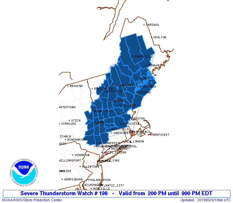
Severe Thunderstorm Watch Number 198
NWS Storm Prediction Center Norman OK
200 PM EDT Mon May 20 2019
The NWS Storm Prediction Center has issued a
* Severe Thunderstorm Watch for portions of
Western Connecticut
Western and Central Massachusetts
Central and Western Maine
New Hampshire
Southeast New York
Central and Southern Vermont
Coastal Waters
* Effective this Monday afternoon and evening from 200 PM until
900 PM EDT.
* Primary threats include...
Scattered damaging wind gusts to 70 mph possible
Isolated large hail events to 1 inch in diameter possible
SUMMARY...A few strong to severe thunderstorms are expected to track
across the watch area through the afternoon and early evening,
posing a risk of locally damaging wind gusts.
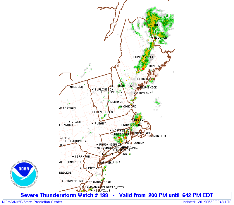
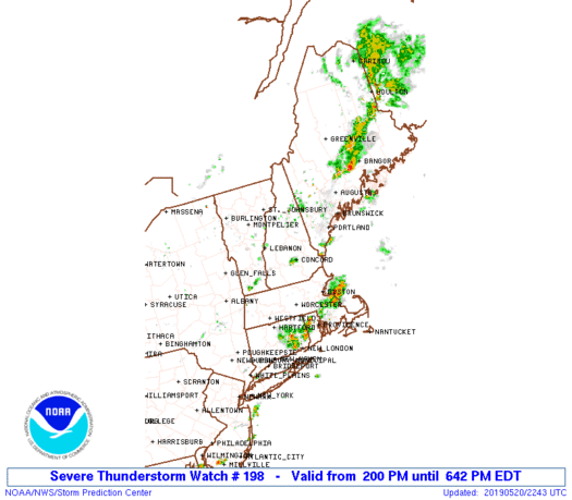
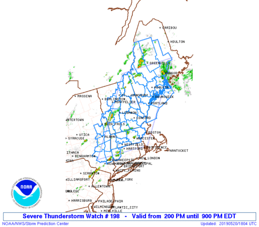
The severe thunderstorm watch area is approximately along and 85
statute miles east and west of a line from 55 miles northwest of
Bangor ME to 15 miles southwest of Windsor Locks CT. For a complete
depiction of the watch see the associated watch outline update
(WOUS64 KWNS WOU8).
PRECAUTIONARY/PREPAREDNESS ACTIONS...
REMEMBER...A Severe Thunderstorm Watch means conditions are
favorable for severe thunderstorms in and close to the watch area.
Persons in these areas should be on the lookout for threatening
weather conditions and listen for later statements and possible
warnings. Severe thunderstorms can and occasionally do produce
tornadoes.
&&
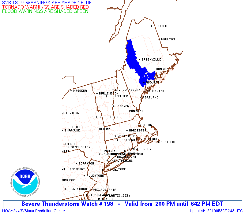
OTHER WATCH INFORMATION...CONTINUE...WW 196...WW 197...
AVIATION...A few severe thunderstorms with hail surface and aloft to
1 inch. Extreme turbulence and surface wind gusts to 60 knots. A few
cumulonimbi with maximum tops to 450. Mean storm motion vector
26030.
...Hart
   SEL8

   URGENT - IMMEDIATE BROADCAST REQUESTED
   Severe Thunderstorm Watch Number 198
   NWS Storm Prediction Center Norman OK
   200 PM EDT Mon May 20 2019

   The NWS Storm Prediction Center has issued a

   * Severe Thunderstorm Watch for portions of
     Western Connecticut
     Western and Central Massachusetts
     Central and Western Maine
     New Hampshire
     Southeast New York
     Central and Southern Vermont
     Coastal Waters

   * Effective this Monday afternoon and evening from 200 PM until
     900 PM EDT.

   * Primary threats include...
     Scattered damaging wind gusts to 70 mph possible
     Isolated large hail events to 1 inch in diameter possible

   SUMMARY...A few strong to severe thunderstorms are expected to track
   across the watch area through the afternoon and early evening,
   posing a risk of locally damaging wind gusts.

   The severe thunderstorm watch area is approximately along and 85
   statute miles east and west of a line from 55 miles northwest of
   Bangor ME to 15 miles southwest of Windsor Locks CT. For a complete
   depiction of the watch see the associated watch outline update
   (WOUS64 KWNS WOU8).

   PRECAUTIONARY/PREPAREDNESS ACTIONS...

   REMEMBER...A Severe Thunderstorm Watch means conditions are
   favorable for severe thunderstorms in and close to the watch area.
   Persons in these areas should be on the lookout for threatening
   weather conditions and listen for later statements and possible
   warnings. Severe thunderstorms can and occasionally do produce
   tornadoes.

   &&

   OTHER WATCH INFORMATION...CONTINUE...WW 196...WW 197...

   AVIATION...A few severe thunderstorms with hail surface and aloft to
   1 inch. Extreme turbulence and surface wind gusts to 60 knots. A few
   cumulonimbi with maximum tops to 450. Mean storm motion vector
   26030.

   ...Hart
 Note:
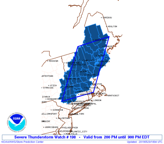
The Aviation Watch (SAW) product is an approximation to the watch area.
The actual watch is depicted by the shaded areas.
Note:
The Aviation Watch (SAW) product is an approximation to the watch area.
The actual watch is depicted by the shaded areas.
   SAW8
   WW 198 SEVERE TSTM CT MA ME NH NY VT CW 201800Z - 210100Z
   AXIS..85 STATUTE MILES EAST AND WEST OF LINE..
   55NW BGR/BANGOR ME/ - 15SW BDL/WINDSOR LOCKS CT/
   ..AVIATION COORDS.. 75NM E/W /45NW BGR - 12SSW BDL/
   HAIL SURFACE AND ALOFT..1 INCH. WIND GUSTS..60 KNOTS.
   MAX TOPS TO 450. MEAN STORM MOTION VECTOR 26030.

   LAT...LON 45346787 41757119 41757448 45347137

   THIS IS AN APPROXIMATION TO THE WATCH AREA.  FOR A
   COMPLETE DEPICTION OF THE WATCH SEE WOUS64 KWNS
   FOR WOU8.
Watch 198 Status Report Messages:
STATUS REPORT #5 ON WW 198

VALID 202245Z - 202340Z

SEVERE WEATHER THREAT CONTINUES RIGHT OF A LINE FROM 35 ESE PSM
TO 30 NW BOS TO 10 SSW EEN TO 25 E MPV TO 40 N BGR.

..MARSH..05/20/19

ATTN...WFO...ALY...BOX...GYX...CAR...BTV...

&&

STATUS REPORT FOR WS 198

SEVERE WEATHER THREAT CONTINUES FOR THE FOLLOWING AREAS

MEC001-005-011-013-015-017-023-027-031-202340-

ME
.    MAINE COUNTIES INCLUDED ARE

ANDROSCOGGIN	     CUMBERLAND 	 KENNEBEC
KNOX		     LINCOLN		 OXFORD
SAGADAHOC	     WALDO		 YORK
$$


NHC001-003-005-009-011-013-015-017-019-202340-

NH
.    NEW HAMPSHIRE COUNTIES INCLUDED ARE

BELKNAP 	     CARROLL		 CHESHIRE
GRAFTON 	     HILLSBOROUGH	 MERRIMACK
ROCKINGHAM	     STRAFFORD		 SULLIVAN
$$


ANZ150-151-152-153-154-202340-

CW

.    ADJACENT COASTAL WATERS INCLUDED ARE

COASTAL WATERS FROM STONINGTON ME TO PORT CLYDE ME OUT 25 NM

PENOBSCOT BAY

COASTAL WATERS FROM PORT CLYDE ME TO CAPE ELIZABETH ME OUT 25 NM

CASCO BAY

COASTAL WATERS FROM CAPE ELIZABETH ME TO MERRIMACK RIVER MA OUT
25 NM

$$
THE WATCH STATUS MESSAGE IS FOR GUIDANCE PURPOSES ONLY.  PLEASE
REFER TO WATCH COUNTY NOTIFICATION STATEMENTS FOR OFFICIAL
INFORMATION ON COUNTIES...INDEPENDENT CITIES AND MARINE ZONES
CLEARED FROM SEVERE THUNDERSTORM AND TORNADO WATCHES.
$$

STATUS REPORT #4 ON WW 198

VALID 202145Z - 202240Z

SEVERE WEATHER THREAT CONTINUES RIGHT OF A LINE FROM 35 ESE PSM
TO 15 SW BDL AND 10 SSE MPV TO 55 NW BGR.

FOR ADDITIONAL INFORMATION SEE MESOSCALE DISCUSSION 706.

..MARSH..05/20/19

ATTN...WFO...ALY...BOX...GYX...CAR...BTV...

&&

STATUS REPORT FOR WS 198

SEVERE WEATHER THREAT CONTINUES FOR THE FOLLOWING AREAS

MEC001-005-007-011-013-015-017-019-021-023-027-031-202240-

ME
.    MAINE COUNTIES INCLUDED ARE

ANDROSCOGGIN	     CUMBERLAND 	 FRANKLIN
KENNEBEC	     KNOX		 LINCOLN
OXFORD		     PENOBSCOT		 PISCATAQUIS
SAGADAHOC	     WALDO		 YORK
$$


NHC001-003-005-007-009-011-013-015-017-019-202240-

NH
.    NEW HAMPSHIRE COUNTIES INCLUDED ARE

BELKNAP 	     CARROLL		 CHESHIRE
COOS		     GRAFTON		 HILLSBOROUGH
MERRIMACK	     ROCKINGHAM 	 STRAFFORD
SULLIVAN
$$


ANZ150-151-152-153-154-202240-

CW

.    ADJACENT COASTAL WATERS INCLUDED ARE

COASTAL WATERS FROM STONINGTON ME TO PORT CLYDE ME OUT 25 NM

PENOBSCOT BAY

COASTAL WATERS FROM PORT CLYDE ME TO CAPE ELIZABETH ME OUT 25 NM

CASCO BAY

COASTAL WATERS FROM CAPE ELIZABETH ME TO MERRIMACK RIVER MA OUT
25 NM

$$
THE WATCH STATUS MESSAGE IS FOR GUIDANCE PURPOSES ONLY.  PLEASE
REFER TO WATCH COUNTY NOTIFICATION STATEMENTS FOR OFFICIAL
INFORMATION ON COUNTIES...INDEPENDENT CITIES AND MARINE ZONES
CLEARED FROM SEVERE THUNDERSTORM AND TORNADO WATCHES.
$$

STATUS REPORT #3 ON WW 198

VALID 202040Z - 202140Z

SEVERE WEATHER THREAT CONTINUES RIGHT OF A LINE FROM 10 ESE MPV
TO 10 NNW BML TO 70 NE BML.

..MARSH..05/20/19

ATTN...WFO...ALY...BOX...GYX...CAR...BTV...

&&

STATUS REPORT FOR WS 198

SEVERE WEATHER THREAT CONTINUES FOR THE FOLLOWING AREAS

CTC005-202140-

CT
.    CONNECTICUT COUNTIES INCLUDED ARE

LITCHFIELD
$$


MEC001-005-007-011-013-015-017-019-021-023-025-027-031-202140-

ME
.    MAINE COUNTIES INCLUDED ARE

ANDROSCOGGIN	     CUMBERLAND 	 FRANKLIN
KENNEBEC	     KNOX		 LINCOLN
OXFORD		     PENOBSCOT		 PISCATAQUIS
SAGADAHOC	     SOMERSET		 WALDO
YORK
$$


MAC003-011-013-015-017-027-202140-

MA
.    MASSACHUSETTS COUNTIES INCLUDED ARE

BERKSHIRE	     FRANKLIN		 HAMPDEN
HAMPSHIRE	     MIDDLESEX		 WORCESTER
$$


NHC001-003-005-007-009-011-013-015-017-019-202140-

NH
.    NEW HAMPSHIRE COUNTIES INCLUDED ARE

BELKNAP 	     CARROLL		 CHESHIRE
COOS		     GRAFTON		 HILLSBOROUGH
MERRIMACK	     ROCKINGHAM 	 STRAFFORD
SULLIVAN
$$


NYC001-021-027-039-083-091-093-111-115-202140-

NY
.    NEW YORK COUNTIES INCLUDED ARE

ALBANY		     COLUMBIA		 DUTCHESS
GREENE		     RENSSELAER 	 SARATOGA
SCHENECTADY	     ULSTER		 WASHINGTON
$$


VTC003-017-021-025-027-202140-

VT
.    VERMONT COUNTIES INCLUDED ARE

BENNINGTON	     ORANGE		 RUTLAND
WINDHAM 	     WINDSOR
$$


ANZ150-151-152-153-154-202140-

CW

.    ADJACENT COASTAL WATERS INCLUDED ARE

COASTAL WATERS FROM STONINGTON ME TO PORT CLYDE ME OUT 25 NM

PENOBSCOT BAY

COASTAL WATERS FROM PORT CLYDE ME TO CAPE ELIZABETH ME OUT 25 NM

CASCO BAY

COASTAL WATERS FROM CAPE ELIZABETH ME TO MERRIMACK RIVER MA OUT
25 NM

$$
THE WATCH STATUS MESSAGE IS FOR GUIDANCE PURPOSES ONLY.  PLEASE
REFER TO WATCH COUNTY NOTIFICATION STATEMENTS FOR OFFICIAL
INFORMATION ON COUNTIES...INDEPENDENT CITIES AND MARINE ZONES
CLEARED FROM SEVERE THUNDERSTORM AND TORNADO WATCHES.
$$

STATUS REPORT #2 ON WW 198

VALID 201940Z - 202040Z

THE SEVERE WEATHER THREAT CONTINUES ACROSS THE ENTIRE WATCH AREA.

..MARSH..05/20/19

ATTN...WFO...ALY...BOX...GYX...CAR...BTV...

&&

STATUS REPORT FOR WS 198

SEVERE WEATHER THREAT CONTINUES FOR THE FOLLOWING AREAS

CTC005-202040-

CT
.    CONNECTICUT COUNTIES INCLUDED ARE

LITCHFIELD
$$


MEC001-005-007-011-013-015-017-019-021-023-025-027-031-202040-

ME
.    MAINE COUNTIES INCLUDED ARE

ANDROSCOGGIN	     CUMBERLAND 	 FRANKLIN
KENNEBEC	     KNOX		 LINCOLN
OXFORD		     PENOBSCOT		 PISCATAQUIS
SAGADAHOC	     SOMERSET		 WALDO
YORK
$$


MAC003-011-013-015-017-027-202040-

MA
.    MASSACHUSETTS COUNTIES INCLUDED ARE

BERKSHIRE	     FRANKLIN		 HAMPDEN
HAMPSHIRE	     MIDDLESEX		 WORCESTER
$$


NHC001-003-005-007-009-011-013-015-017-019-202040-

NH
.    NEW HAMPSHIRE COUNTIES INCLUDED ARE

BELKNAP 	     CARROLL		 CHESHIRE
COOS		     GRAFTON		 HILLSBOROUGH
MERRIMACK	     ROCKINGHAM 	 STRAFFORD
SULLIVAN
$$


NYC001-021-027-039-083-091-093-111-115-202040-

NY
.    NEW YORK COUNTIES INCLUDED ARE

ALBANY		     COLUMBIA		 DUTCHESS
GREENE		     RENSSELAER 	 SARATOGA
SCHENECTADY	     ULSTER		 WASHINGTON
$$


VTC003-005-009-017-021-023-025-027-202040-

VT
.    VERMONT COUNTIES INCLUDED ARE

BENNINGTON	     CALEDONIA		 ESSEX
ORANGE		     RUTLAND		 WASHINGTON
WINDHAM 	     WINDSOR
$$


ANZ150-151-152-153-154-202040-

CW

.    ADJACENT COASTAL WATERS INCLUDED ARE

COASTAL WATERS FROM STONINGTON ME TO PORT CLYDE ME OUT 25 NM

PENOBSCOT BAY

COASTAL WATERS FROM PORT CLYDE ME TO CAPE ELIZABETH ME OUT 25 NM

CASCO BAY

COASTAL WATERS FROM CAPE ELIZABETH ME TO MERRIMACK RIVER MA OUT
25 NM

$$
THE WATCH STATUS MESSAGE IS FOR GUIDANCE PURPOSES ONLY.  PLEASE
REFER TO WATCH COUNTY NOTIFICATION STATEMENTS FOR OFFICIAL
INFORMATION ON COUNTIES...INDEPENDENT CITIES AND MARINE ZONES
CLEARED FROM SEVERE THUNDERSTORM AND TORNADO WATCHES.
$$

STATUS REPORT #1 ON WW 198

VALID 201855Z - 201940Z

THE SEVERE WEATHER THREAT CONTINUES ACROSS THE ENTIRE WATCH AREA.

..MARSH..05/20/19

ATTN...WFO...ALY...BOX...GYX...CAR...BTV...

&&

STATUS REPORT FOR WS 198

SEVERE WEATHER THREAT CONTINUES FOR THE FOLLOWING AREAS

CTC005-201940-

CT
.    CONNECTICUT COUNTIES INCLUDED ARE

LITCHFIELD
$$


MEC001-005-007-011-013-015-017-019-021-023-025-027-031-201940-

ME
.    MAINE COUNTIES INCLUDED ARE

ANDROSCOGGIN	     CUMBERLAND 	 FRANKLIN
KENNEBEC	     KNOX		 LINCOLN
OXFORD		     PENOBSCOT		 PISCATAQUIS
SAGADAHOC	     SOMERSET		 WALDO
YORK
$$


MAC003-011-013-015-017-027-201940-

MA
.    MASSACHUSETTS COUNTIES INCLUDED ARE

BERKSHIRE	     FRANKLIN		 HAMPDEN
HAMPSHIRE	     MIDDLESEX		 WORCESTER
$$


NHC001-003-005-007-009-011-013-015-017-019-201940-

NH
.    NEW HAMPSHIRE COUNTIES INCLUDED ARE

BELKNAP 	     CARROLL		 CHESHIRE
COOS		     GRAFTON		 HILLSBOROUGH
MERRIMACK	     ROCKINGHAM 	 STRAFFORD
SULLIVAN
$$


NYC001-021-027-039-083-091-093-111-115-201940-

NY
.    NEW YORK COUNTIES INCLUDED ARE

ALBANY		     COLUMBIA		 DUTCHESS
GREENE		     RENSSELAER 	 SARATOGA
SCHENECTADY	     ULSTER		 WASHINGTON
$$


VTC003-005-009-017-021-023-025-027-201940-

VT
.    VERMONT COUNTIES INCLUDED ARE

BENNINGTON	     CALEDONIA		 ESSEX
ORANGE		     RUTLAND		 WASHINGTON
WINDHAM 	     WINDSOR
$$


ANZ150-151-152-153-154-201940-

CW

.    ADJACENT COASTAL WATERS INCLUDED ARE

COASTAL WATERS FROM STONINGTON ME TO PORT CLYDE ME OUT 25 NM

PENOBSCOT BAY

COASTAL WATERS FROM PORT CLYDE ME TO CAPE ELIZABETH ME OUT 25 NM

CASCO BAY

COASTAL WATERS FROM CAPE ELIZABETH ME TO MERRIMACK RIVER MA OUT
25 NM

$$
THE WATCH STATUS MESSAGE IS FOR GUIDANCE PURPOSES ONLY.  PLEASE
REFER TO WATCH COUNTY NOTIFICATION STATEMENTS FOR OFFICIAL
INFORMATION ON COUNTIES...INDEPENDENT CITIES AND MARINE ZONES
CLEARED FROM SEVERE THUNDERSTORM AND TORNADO WATCHES.
$$
Note:
Click for Complete Product Text.
Tornadoes
Probability of 2 or more tornadoes
|
Low (10%)
|
Probability of 1 or more strong (EF2-EF5) tornadoes
|
Low (<2%)
|
Wind
Probability of 10 or more severe wind events
|
Mod (40%)
|
Probability of 1 or more wind events > 65 knots
|
Low (20%)
|
Hail
Probability of 10 or more severe hail events
|
Mod (30%)
|
Probability of 1 or more hailstones > 2 inches
|
Low (20%)
|
Combined Severe Hail/Wind
Probability of 6 or more combined severe hail/wind events
|
High (70%)
|
For each watch, probabilities for particular events inside the watch
(listed above in each table) are determined by the issuing forecaster.
The "Low" category contains probability values ranging from less than 2%
to 20% (EF2-EF5 tornadoes), less than 5% to 20% (all other probabilities),
"Moderate" from 30% to 60%, and "High" from 70% to greater than 95%.
High values are bolded and lighter in color to provide awareness of
an increased threat for a particular event.


 @NWSSPC