Note:
The expiration time in the watch graphic is amended if the watch is
replaced, cancelled or extended.
Note:
Note:
The expiration time in the watch graphic is amended if the watch is
replaced, cancelled or extended.
Note: Click for
Watch Status Reports.
SEL6
URGENT - IMMEDIATE BROADCAST REQUESTED
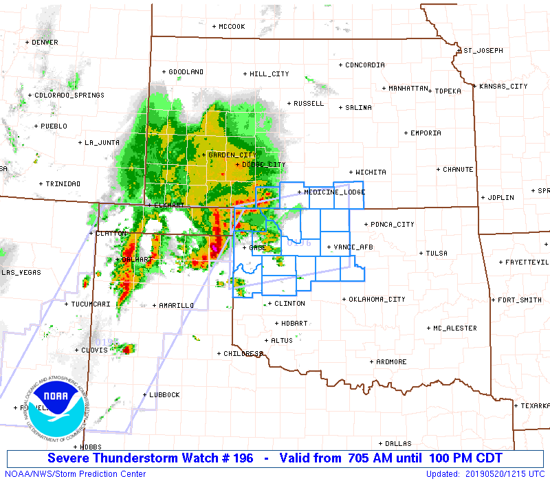
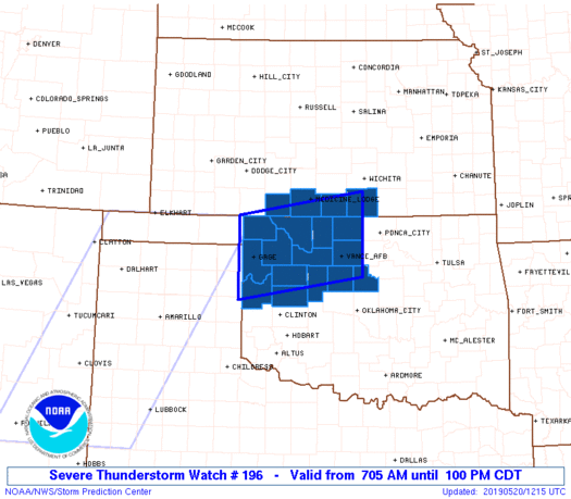
Severe Thunderstorm Watch Number 196
NWS Storm Prediction Center Norman OK
705 AM CDT Mon May 20 2019
The NWS Storm Prediction Center has issued a
* Severe Thunderstorm Watch for portions of
Extreme south-central Kansas
Northwestern Oklahoma
* Effective this Monday morning and afternoon from 705 AM until
100 PM CDT.
* Primary threats include...
Scattered large hail and isolated very large hail events to 2.5
inches in diameter possible
Scattered damaging wind gusts to 70 mph possible
SUMMARY...A complex of elevated severe thunderstorms will move
eastward to east-northeastward out of the Texas Panhandle. This and
perhaps trailing convection will offering large hail and potentially
damaging gusts penetrating a shallow stable layer near the surface,
as it encounters a moistening and destabilizing air mass. Tornado
watch(es) may be needed for especially southern parts of the same
area later today, as that threat increases with approach of the warm
front.
The severe thunderstorm watch area is approximately along and 50
statute miles north and south of a line from 85 miles west southwest
of Alva OK to 35 miles northeast of Enid OK. For a complete
depiction of the watch see the associated watch outline update
(WOUS64 KWNS WOU6).
PRECAUTIONARY/PREPAREDNESS ACTIONS...
REMEMBER...A Severe Thunderstorm Watch means conditions are
favorable for severe thunderstorms in and close to the watch area.
Persons in these areas should be on the lookout for threatening
weather conditions and listen for later statements and possible
warnings. Severe thunderstorms can and occasionally do produce
tornadoes.
&&
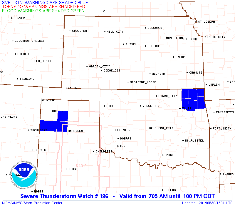
OTHER WATCH INFORMATION...CONTINUE...WW 195...
AVIATION...A few severe thunderstorms with hail surface and aloft to
2.5 inches. Extreme turbulence and surface wind gusts to 60 knots. A
few cumulonimbi with maximum tops to 500. Mean storm motion vector
26035.
...Edwards

   SEL6

   URGENT - IMMEDIATE BROADCAST REQUESTED
   Severe Thunderstorm Watch Number 196
   NWS Storm Prediction Center Norman OK
   705 AM CDT Mon May 20 2019

   The NWS Storm Prediction Center has issued a

   * Severe Thunderstorm Watch for portions of
     Extreme south-central Kansas
     Northwestern Oklahoma

   * Effective this Monday morning and afternoon from 705 AM until
     100 PM CDT.

   * Primary threats include...
     Scattered large hail and isolated very large hail events to 2.5
       inches in diameter possible
     Scattered damaging wind gusts to 70 mph possible

   SUMMARY...A complex of elevated severe thunderstorms will move
   eastward to east-northeastward out of the Texas Panhandle.  This and
   perhaps trailing convection will offering large hail and potentially
   damaging gusts penetrating a shallow stable layer near the surface,
   as it encounters a moistening and destabilizing air mass.  Tornado
   watch(es) may be needed for especially southern parts of the same
   area later today, as that threat increases with approach of the warm
   front.

   The severe thunderstorm watch area is approximately along and 50
   statute miles north and south of a line from 85 miles west southwest
   of Alva OK to 35 miles northeast of Enid OK. For a complete
   depiction of the watch see the associated watch outline update
   (WOUS64 KWNS WOU6).

   PRECAUTIONARY/PREPAREDNESS ACTIONS...

   REMEMBER...A Severe Thunderstorm Watch means conditions are
   favorable for severe thunderstorms in and close to the watch area.
   Persons in these areas should be on the lookout for threatening
   weather conditions and listen for later statements and possible
   warnings. Severe thunderstorms can and occasionally do produce
   tornadoes.

   &&

   OTHER WATCH INFORMATION...CONTINUE...WW 195...

   AVIATION...A few severe thunderstorms with hail surface and aloft to
   2.5 inches. Extreme turbulence and surface wind gusts to 60 knots. A
   few cumulonimbi with maximum tops to 500. Mean storm motion vector
   26035.

   ...Edwards
 Note:
The Aviation Watch (SAW) product is an approximation to the watch area.
The actual watch is depicted by the shaded areas.
Note:
The Aviation Watch (SAW) product is an approximation to the watch area.
The actual watch is depicted by the shaded areas.
   SAW6
   WW 196 SEVERE TSTM KS OK 201205Z - 201800Z
   AXIS..50 STATUTE MILES NORTH AND SOUTH OF LINE..
   85WSW AVK/ALVA OK/ - 35NE END/ENID OK/
   ..AVIATION COORDS.. 45NM N/S /10WSW MMB - 30NE END/
   HAIL SURFACE AND ALOFT..2.5 INCHES. WIND GUSTS..60 KNOTS.
   MAX TOPS TO 500. MEAN STORM MOTION VECTOR 26035.

   LAT...LON 37000008 37439747 35979747 35560008

   THIS IS AN APPROXIMATION TO THE WATCH AREA.  FOR A
   COMPLETE DEPICTION OF THE WATCH SEE WOUS64 KWNS
   FOR WOU6.
Watch 196 Status Report Messages:
STATUS REPORT #2 ON WW 196

VALID 201540Z - 201640Z

THE SEVERE WEATHER THREAT CONTINUES ACROSS THE ENTIRE WATCH AREA.

..MARSH..05/20/19

ATTN...WFO...DDC...ICT...OUN...

&&

STATUS REPORT FOR WS 196

SEVERE WEATHER THREAT CONTINUES FOR THE FOLLOWING AREAS

KSC007-033-077-191-201640-

KS
.    KANSAS COUNTIES INCLUDED ARE

BARBER		     COMANCHE		 HARPER
SUMNER
$$


OKC003-011-039-043-045-047-053-059-071-073-083-093-103-119-129-
151-153-201640-

OK
.    OKLAHOMA COUNTIES INCLUDED ARE

ALFALFA 	     BLAINE		 CUSTER
DEWEY		     ELLIS		 GARFIELD
GRANT		     HARPER		 KAY
KINGFISHER	     LOGAN		 MAJOR
NOBLE		     PAYNE		 ROGER MILLS
WOODS		     WOODWARD
$$


THE WATCH STATUS MESSAGE IS FOR GUIDANCE PURPOSES ONLY.  PLEASE
REFER TO WATCH COUNTY NOTIFICATION STATEMENTS FOR OFFICIAL
INFORMATION ON COUNTIES...INDEPENDENT CITIES AND MARINE ZONES
CLEARED FROM SEVERE THUNDERSTORM AND TORNADO WATCHES.
$$

STATUS REPORT #1 ON WW 196

VALID 201340Z - 201440Z

THE SEVERE WEATHER THREAT CONTINUES ACROSS THE ENTIRE WATCH AREA.

..KARSTENS..05/20/19

ATTN...WFO...DDC...ICT...OUN...

&&

STATUS REPORT FOR WS 196

SEVERE WEATHER THREAT CONTINUES FOR THE FOLLOWING AREAS

KSC007-033-077-191-201440-

KS
.    KANSAS COUNTIES INCLUDED ARE

BARBER		     COMANCHE		 HARPER
SUMNER
$$


OKC003-011-039-043-045-047-053-059-073-083-093-129-151-153-
201440-

OK
.    OKLAHOMA COUNTIES INCLUDED ARE

ALFALFA 	     BLAINE		 CUSTER
DEWEY		     ELLIS		 GARFIELD
GRANT		     HARPER		 KINGFISHER
LOGAN		     MAJOR		 ROGER MILLS
WOODS		     WOODWARD
$$


THE WATCH STATUS MESSAGE IS FOR GUIDANCE PURPOSES ONLY.  PLEASE
REFER TO WATCH COUNTY NOTIFICATION STATEMENTS FOR OFFICIAL
INFORMATION ON COUNTIES...INDEPENDENT CITIES AND MARINE ZONES
CLEARED FROM SEVERE THUNDERSTORM AND TORNADO WATCHES.
$$
Note:
Click for Complete Product Text.
Tornadoes
Probability of 2 or more tornadoes
|
Low (10%)
|
Probability of 1 or more strong (EF2-EF5) tornadoes
|
Low (5%)
|
Wind
Probability of 10 or more severe wind events
|
Mod (50%)
|
Probability of 1 or more wind events > 65 knots
|
Low (10%)
|
Hail
Probability of 10 or more severe hail events
|
Mod (50%)
|
Probability of 1 or more hailstones > 2 inches
|
Mod (50%)
|
Combined Severe Hail/Wind
Probability of 6 or more combined severe hail/wind events
|
High (80%)
|
For each watch, probabilities for particular events inside the watch
(listed above in each table) are determined by the issuing forecaster.
The "Low" category contains probability values ranging from less than 2%
to 20% (EF2-EF5 tornadoes), less than 5% to 20% (all other probabilities),
"Moderate" from 30% to 60%, and "High" from 70% to greater than 95%.
High values are bolded and lighter in color to provide awareness of
an increased threat for a particular event.


 @NWSSPC