SPC AC 251944
Day 1 Convective Outlook
NWS Storm Prediction Center Norman OK
0244 PM CDT Fri Apr 25 2025
Valid 252000Z - 261200Z
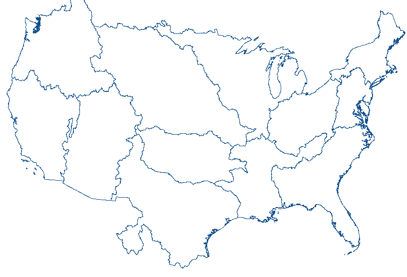
...THERE IS AN ENHANCED RISK OF SEVERE THUNDERSTORMS FAR
EAST-CENTRAL NEW MEXICO INTO THE TEXAS SOUTH PLAINS AND CAPROCK...
...SUMMARY...
A concentrated area of severe thunderstorms is forecast centered on
the Texas South Plains during the late afternoon and evening. A few
tornadoes will be possible, as well as large to giant hail being
probable with the more intense supercells.
...20z Update...
Tornado risk probabilities have been increased to 10% (with
significant hatching) within a focused corridor across parts of the
TX South Plains/Caprock. Latest radar imagery shows convective
initiation well underway along a residual outflow boundary to the
northwest of the Lubbock, TX area. Additional convective towers are
noted in visible imagery to the east of the developing storm,
lending high confidence in supercell development within the coming
hours. These cells will likely propagate to the east/southeast along
residual boundaries into a region with mid 60s dewpoints (moisture
that is above the 90th percentile for west TX in late April) and
east/southeasterly low-level flow. Weak 1-3 km winds have been
recently noted in regional VWPs that will favor a very large hail
threat through late afternoon; however, increasing flow within the
925-850 mb layer after 00z will result in low-level hodograph
enlargement and promote an increasing tornado threat (including the
potential for a strong tornado) heading into the evening hours prior
to upscale growth later tonight. See the previous discussion below
for additional details.
..Moore.. 04/25/2025
.PREV DISCUSSION... /ISSUED 1145 AM CDT Fri Apr 25 2025/
...Far Eastern NM...TX Panhandle...West TX...
Upper ridging over the High Plains will be downstream of a western
U.S. upper trough. In the low levels, a frontal zone has pushed
south into the TX Panhandle with a diffuse outflow boundary
extending from east TX west-northwestward into the Low Rolling
Plains/Caprock vicinity. Farther west, a dryline extends south over
eastern NM with a seasonably moisture-rich airmass (60s surface
dewpoints) located south and east of the aforementioned boundaries.
Visible satellite imagery shows mostly clear skies with strong
heating expected through the late afternoon.
Model guidance shows 2000-3000 J/kg MLCAPE developing by mid-late
afternoon as convective inhibition gradually erodes near the
boundaries. Forecast soundings show southeasterly to southerly flow
veering to 20-30 kt southwesterly mid-level flow, and further
increasing to 70-kt in the upper levels. The magnitude of buoyancy
and shear will strongly favor intense supercells initially. Large
to giant hail (up to 2.5 to 4.0 inches in diameter) will likely
accompany the stronger supercells. A tornado risk will probably
focus in the vicinity of mesoscale boundaries and peak during the
early evening, when a strengthening of low-level flow is expected.
Upscale growth into a cluster is possible this evening with the
hail/tornado risk gradually transitioning to mostly a wind risk
late.
Farther south into the Permian Basin, a couple of intense supercells
are possible later this afternoon into the evening. Large to giant
hail appears to be the primary severe hazard, although a tornado is
possible during the early evening.
...Lower MS Valley/Southeast into TN and OH Valley...
Scattered to numerous showers/thunderstorms are forecast to develop
from the OH Valley south into the lower MS Valley within a
moist/weakly unstable airmass. Some modest enhancement to low-level
flow and hodographs over parts of the OH Valley may result in a few
transient organized cells. Despite moist profiles and limited lapse
rates, localized wind damage (45-55 mph gusts) may accompany the
stronger storms for a few hours this afternoon.
CLICK TO GET WUUS01 PTSDY1 PRODUCT
NOTE: THE NEXT DAY 1 OUTLOOK IS SCHEDULED BY 0100Z


 @NWSSPC