SPC AC 020549
Day 1 Convective Outlook
NWS Storm Prediction Center Norman OK
1249 AM CDT Tue Jul 02 2024
Valid 021200Z - 031200Z
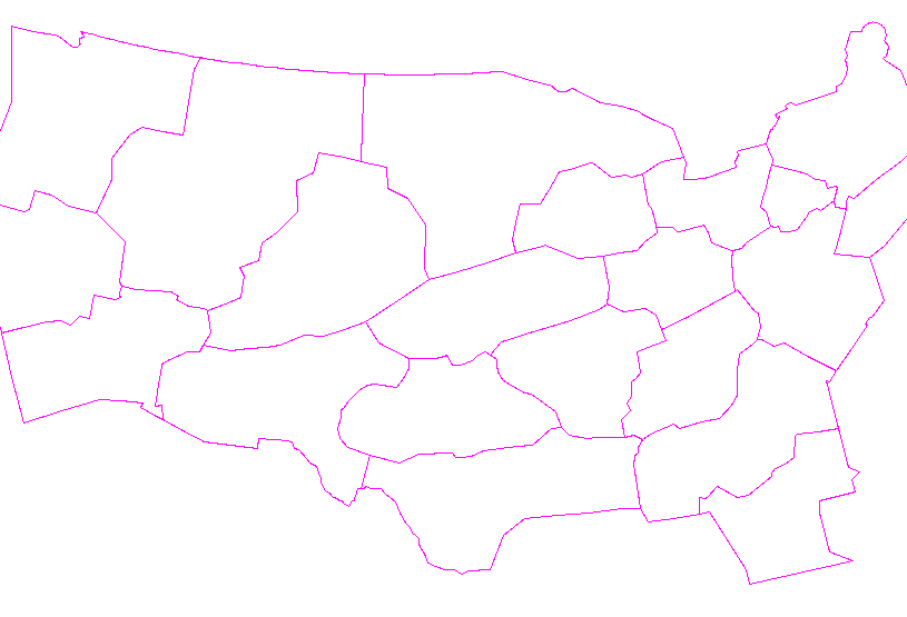
...THERE IS AN ENHANCED RISK OF SEVERE THUNDERSTORMS IN NORTHEAST
KS...SOUTHERN IA...AND NORTHERN MO...
...SUMMARY...
Scattered severe thunderstorms are most likely over southern Iowa,
northern Missouri, and northeast Kansas between about 2 to 9 PM CDT.
Damaging winds, a few tornadoes, and large hail are the expected
hazards.
...Synopsis...
The broad mid/upper trough from the Prairie Provinces to the
Intermountain West will shift east into far northwest Ontario to the
Upper Midwest by tonight. Multiple embedded shortwave impulses, some
of which are convectively enhanced, will progress within and ahead
of the trough. The most prominent of which for severe potential is
approaching the WY Rockies, and will track across the Mid-MO Valley
to the Upper MS Valley by early Wednesday. A belt of enhanced
mid-level southwesterlies in excess of 50 kts will amplify ahead of
this impulse and spread over the Mid-MO to Upper MS Valley by late
afternoon.
...Central KS to the Mid-MS Valley...
A swath of decaying convection should be ongoing at 12Z this morning
from parts of the Mid-MO Valley to the western Great Lakes.
Differential boundary-layer heating amid pronounced insolation
occurring to the south of morning outflow/cloud debris will yield a
strengthening baroclinic zone from central KS northeastward into
southeast IA. With minimal capping, renewed surface-based convection
should occur in the early afternoon along this effective front. The
aforementioned amplification of mid-level southwesterlies later in
the day will aid in sustaining organized upscale growth, with
embedded supercell and bowing structures possible. This appears to
be most favored from northeast KS across northern MO and southern
IA. Swaths of strong to severe gusts and a few tornadoes are
possible. The northeast extent of the severe threat should abruptly
diminish east of the MS River into IL, as convection eventually
outpaces the north/south-oriented buoyancy plume. This should result
in a progressive north-to-south weakening of the severe threat after
dusk over the Mid-MS/Lower MO Valleys.
...Central/southern High Plains...
At least isolated severe hail and wind will be possible from late
afternoon into mid-evening, within a post-frontal upslope flow
environment from the Raton Mesa to the Black Hills, and a hot/deeply
mixed boundary layer ahead of the front in the OK/TX Panhandle
vicinity. A more favorable corridor for supercell potential is
evident in southeast CO to southwest KS where a plume of richer
low-level moisture will reside north of the trailing front. There
should be some cooling near the mid-level trough to slightly steepen
mid-level lapse rates for a conditional large-hail threat, in
addition to severe gusts. Convection in this region should weaken
after dusk.
..Grams/Squitieri.. 07/02/2024
CLICK TO GET WUUS01 PTSDY1 PRODUCT
NOTE: THE NEXT DAY 1 OUTLOOK IS SCHEDULED BY 1300Z


 @NWSSPC