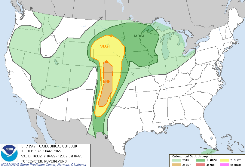
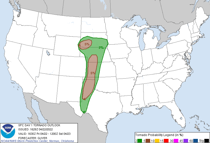
Probability of a tornado within 25 miles of a point. Hatched Area: 10% or greater probability of EF2 - EF5 tornadoes within 25 miles of a point.
Day 1 Tornado Risk
Area (sq. mi.)
Area Pop.
Some Larger Population Centers in Risk Area
5 %
87,215
1,305,293
Lubbock, TX...Amarillo, TX...Rapid City, SD...Garden City, KS...Dodge City, KS...
2 %
132,498
1,464,049
Sioux Falls, SD...Midland, TX...Odessa, TX...Grand Island, NE...Kearney, NE...
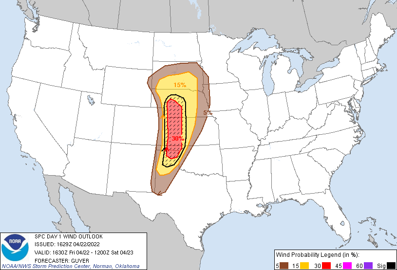
Probabilistic Damaging Wind Graphic
Probability of damaging thunderstorm winds or wind gusts of 50 knots or higher within 25 miles of a point. Hatched Area: 10% of greater probability of wind gusts 65 knots or greater within 25 miles of a point.
Day 1 Wind Risk
Area (sq. mi.)
Area Pop.
Some Larger Population Centers in Risk Area
SIG SEVERE
73,461
767,197
Amarillo, TX...Garden City, KS...Dodge City, KS...North Platte, NE...Liberal, KS...
30 %
41,341
318,121
Garden City, KS...Dodge City, KS...North Platte, NE...Liberal, KS...Guymon, OK...
15 %
124,048
1,206,448
Amarillo, TX...Grand Island, NE...Kearney, NE...Norfolk, NE...Hastings, NE...
5 %
119,641
3,399,483
Omaha, NE...Lincoln, NE...Lubbock, TX...Sioux Falls, SD...Midland, TX...
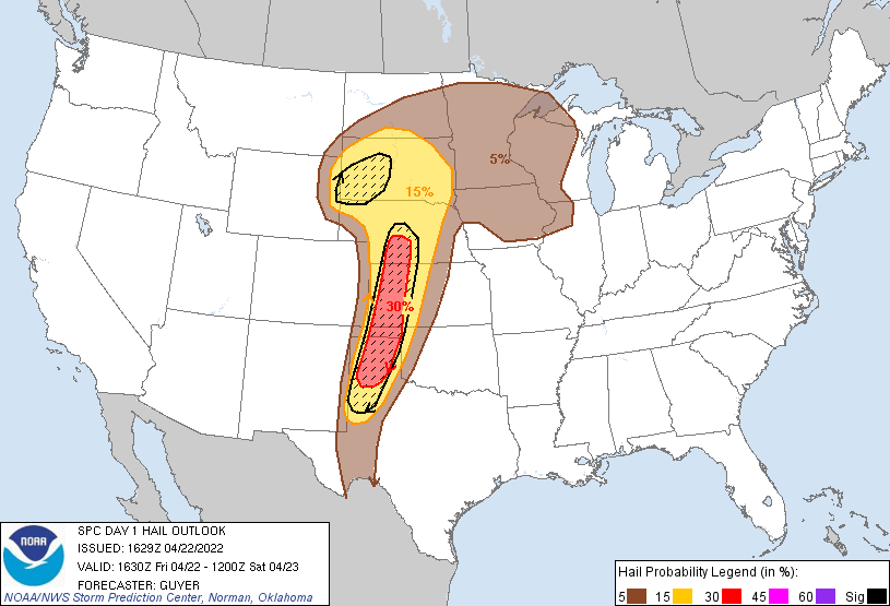
Probabilistic Large Hail Graphic
Probability of hail 1" or larger within 25 miles of a point. Hatched Area: 10% or greater probability of hail 2" or larger within 25 miles of a point.
Day 1 Hail Risk
Area (sq. mi.)
Area Pop.
Some Larger Population Centers in Risk Area
SIG SEVERE
91,181
1,370,253
Lubbock, TX...Amarillo, TX...Rapid City, SD...Kearney, NE...Garden City, KS...
30 %
44,065
657,579
Amarillo, TX...Garden City, KS...Dodge City, KS...Plainview, TX...Liberal, KS...
15 %
173,499
1,762,869
Lubbock, TX...Sioux Falls, SD...Rapid City, SD...Grand Island, NE...Kearney, NE...
   SPC AC 221629

   Day 1 Convective Outlook
   NWS Storm Prediction Center Norman OK
   1129 AM CDT Fri Apr 22 2022

   Valid 221630Z - 231200Z

   ...THERE IS AN ENHANCED RISK OF SEVERE THUNDERSTORMS ACROSS THE
   CENTRAL/SOUTHERN HIGH PLAINS...

   ...SUMMARY...
   At least isolated significant severe weather is possible across
   portions of the High Plains late this afternoon and tonight. Very
   large hail, damaging straight-line winds, and a few tornadoes are
   anticipated.

   ...Southern/central High Plains...
   Early morning /12z/ upper-air analysis features relatively rich
   mid/late-April moisture across the region, with 12+ C 850mb
   dewpoints across western Kansas and all of west Texas
   (DDC-AMA-MAF-DRT) with the moist axis roughly centered along 101W
   longitude. Early/mid-morning visible satellite trends already depict
   a relatively quick erosion of the southern High Plains stratus
   field, particularly on its western edge near the New Mexico/Texas
   border vicinity. This moisture is beneath a stout elevated mixed
   layer and generally coincides with the early day mid-level warm axis
   with 700mb temps 10-12C.

   Ahead of the upper trough/polar jet spreading from the Southwest
   Deserts toward the Four Corners area, robust surface cyclogenesis
   will occur today across northeast Colorado toward western Nebraska
   by evening. As mid-level height falls occur and mixing and
   confluence/convergence increases near the dryline, current thinking
   is that at least widely scattered storms will begin to develop by
   around mid-afternoon within a north-south corridor spanning areas
   from far west Texas to near/just west of the New Mexico/Texas into
   southeast/east-central Colorado.

   Although some warm-sector mixing/lowering of dewpoints can be
   expected, mid 50s to low 60s F surface dewpoints are expected to
   generally persist the east of the dryline, supporting a likely
   intensification as storms progress eastward. 35-40 kt of effective
   shear will support initial high-based supercells capable of very
   large hail. Deep-layer/low-level shear will tend to increase through
   early/mid-evening, while storms will also encounter increased
   moisture content and less mixing. This should result in an increased
   potential for tornadoes by early evening, while strong convective
   wind gusts are also plausible.

   A later round of separate convective development is likely by late
   evening as the Pacific cold front moves eastward and impinges on the
   western extent of the buoyancy plume near the
   Nebraska/Colorado/Kansas border area. This should result in a
   north/south-oriented convective line quickly spreading into western
   portions of Nebraska/Kansas, while also expanding southward
   regionally overnight. Very strong wind profiles should promote a
   threat for severe wind and some hail, although duration and spatial
   extent overnight will probably be limited by the pervasive cold
   low-level theta-e advection in the warm sector, which will reduce
   available CAPE with time.

   ...Far eastern Wyoming/western South Dakota/northwest Nebraska...
   A tight baroclinic zone will lie to the north of the slow-moving
   warm front/quasi-stationary frontal zone extending from the
   deepening central High Plains cyclone. A narrow bent-back plume of
   50s F surface dew points should be maintained beneath an initially
   stout elevated mixed layer. It seems likely that a few surface-based
   storms may ride along the boundary within an SRH-enriched
   environment near the SD/NE border area, while additional storms are
   possible farther west-northwest. Hodographs will be highly
   elongated, yielding the potential for a longer-lived supercell or
   two, with the main threat being significant large hail, although a
   couple of tornadoes could also occur.

   ...Upper Midwest...
   Pending some additional destabilization near a warm front, isolated
   strong to severe storms could occur today near/east of an MCV
   currently across eastern Iowa. Otherwise, additional potentially
   severe development (mostly hail) is possible later tonight across a
   broader part of the Upper Midwest in association with a low-level
   warm theta-e advection regime. This potential will be supported by
   steepening mid-level lapse rates attendant to an expanding Great
   Plains elevated mixed-layer and adequate shear within the
   cloud-bearing layer.

   ..Guyer/Lyons.. 04/22/2022

   CLICK TO GET WUUS01 PTSDY1 PRODUCT

   NOTE: THE NEXT DAY 1 OUTLOOK IS SCHEDULED BY 2000Z