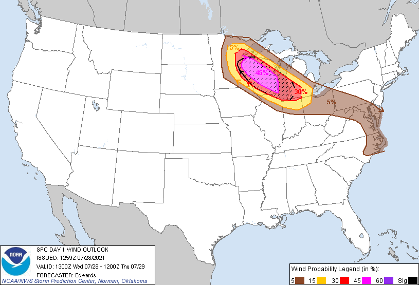
Probability of damaging thunderstorm winds or wind gusts of 50 knots or higher within 25 miles of a point. Hatched Area: 10% of greater probability of wind gusts 65 knots or greater within 25 miles of a point.
Day 1 Wind Risk
Area (sq. mi.)
Area Pop.
Some Larger Population Centers in Risk Area
SIG SEVERE
67,206
10,220,112
Chicago, IL...Milwaukee, WI...Madison, WI...Grand Rapids, MI...Green Bay, WI...
SPC AC 281259
Day 1 Convective Outlook
NWS Storm Prediction Center Norman OK
0759 AM CDT Wed Jul 28 2021
Valid 281300Z - 291200Z
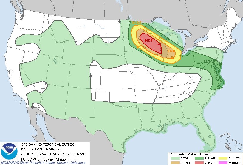
...THERE IS A MODERATE RISK OF SEVERE THUNDERSTORMS OVER PORTIONS OF
WISCONSIN...
...SUMMARY...
This afternoon and evening, a corridor from northeastern Minnesota
across Wisconsin to the southern Lake Michigan region is under
threat of very large hail, severe wind (locally exceeding hurricane
force) and a few tornadoes.
...Synopsis...
In mid/upper levels, a rather stagnant large-scale pattern is
expected over the CONUS, with a strong anticyclone covering much of
the central/northern Rockies and central/southern Plains, to the
Mid-South region. To its northeast, a belt of somewhat difluent
northwest flow aloft will remain from central Canada across the
upper Great Lakes, becoming cyclonic over the lower Great Lakes and
Northeast. Within that flow belt, a subtle shortwave trough -- now
apparent in moisture-channel imagery over parts of SK and MT -- will
move quickly away from the northern Rockies mean-ridge position, to
the eastern ND/northern MN vicinity by 00Z. This perturbation
should proceed southeastward across the upper Great Lakes overnight,
with some likely convective vorticity augmentation/reinforcement.
At the surface, 11Z analysis showed a frontal-wave low over eastern
ND, with cold front across southwestern SD, becoming quasistationary
over central to northwestern MT. A warm front was drawn from the
low across northwestern to southeastern MN, southeastern WI, and
southwestern Lower MI. The low should shift east-southeastward to
southeastward over northern MN, WI, southern Lake Michigan, to
southern Lower MI, by the end of the period. The warm front should
move northward across eastern MN and western/central WI ahead of the
low, especially once ongoing convective influences clear out of the
area (below). The warm-frontal zone will move more slowly over
southeastern WI and southern MI.
...Upper Midwest/Great Lakes...
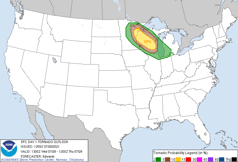
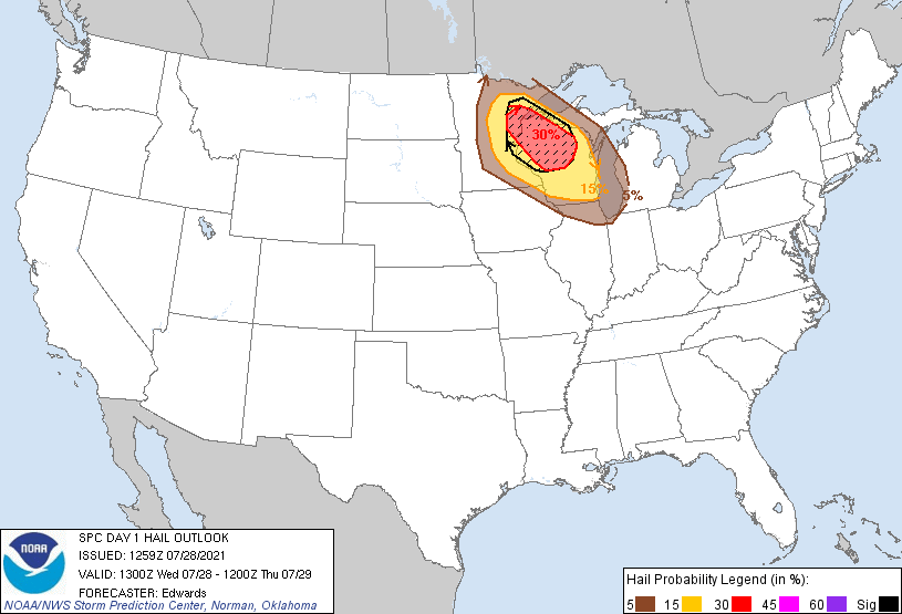
The main severe threat will arise from southeastward-moving
supercells developing this afternoon over parts of northern MN and
northwestern WI. This activity will pose a threat for
significant/destructive hail, a few tornadoes, and severe gusts. At
some point, likely over WI but with some lingering uncertainty how
far southeast, activity should expand into an MCS capable of severe
gusts and tornadoes across the remainder of southern/eastern this
evening, shifting into the southern Lake Michigan and lower MI
vicinity tonight. A derecho may occur, with embedded channels of
hurricane-force gusts.
Isolated severe hail and gusts remain possible from an ongoing area
of thunderstorms (with elevated low-level inflow) across portions of
MN and into western WI, before activity weakens later this morning.
Associated precip has been falling into an already high-theta-e,
moisture-rich boundary layer, with some cooling/stabilizing
influence, but not to the extent expected with a drier antecedent
boundary layer. However, associated thick cloud cover can
impede/delay substantial diurnal heating by a few hours today,
especially over WI, with a differential-heating zone acting as the
effective warm front.
Airmass recovery is expected behind the morning convection during
mid/late afternoon, by means of both boundary-layer theta-e
advection and diabatic heating/destabilization. This process should
progress from west to east across the outlook area and effectively
relocate the warm-frontal position northward. The rich low-level
moisture content (supporting surface dew points commonly in the 70s
F south of the warm-frontal zone) will underlie steep midlevel lapse
rates apparent in 12Z ABR/MPX RAOBs this morning. That, along with
a deep troposphere, will contribute to MLCAPE values in the
2500-4500 J/kg range near and especially south of the warm front
today over MN/WI, and over 2000 J/kg as far southeast as
northeastern IL and perhaps parts of southwestern Lower MI.
Vertical shear will be greatest near the warm front, but favorable
in the warm sector as well, with effective SRH 300-600 J/kg in the
frontal zone, along with 50-70-kt effective-shear magnitudes
area-wide. This parameter space is quite favorable for severe of
all types, with convective mode being the principal determinant.
Whether or not the timing/location of the upscale storm transition
permits the event to be classified officially as a derecho in
hindsight, there is strong concern it will have that kind of intense
and destructive wind impact for at least a few hours. That said,
preceding supercells in the northeastern MN/northern WI area may be
more long-tracked and pose a more-sustained threat of large to very
large hail and tornadoes than evident earlier. The downshear side
of the hail and wind probabilities have been shifted somewhat
southeastward along the corridor accordingly. Also, the 15%+
probabilities in hail and wind have been expanded laterally to
account for:
1. Uncertainty (margin for error) in both axis and width extent of
the supercell and later MCS coverage, and
2. Potential for a wider wind-producing thunderstorm swath (with a
few embedded/QLCS tornadoes possible) near the warm front, whatever
its specific axial position.
...Mid-Atlantic vicinity...
Although large-scale support aloft will be weak at best, diurnal
heating of a richly moist air mass will reduce MLCINH through
mid-late afternoon in support of isolated to scattered thunderstorms
-- especially east of the Appalachians. Damaging gusts will be the
main concern.
Sea-breeze/bay-breeze boundaries also may assist with convective
initiation over near-coastal areas. Modified RAOBs and model
soundings suggest large low-level theta-e and vigorous diabatic
heating will overcome modest midlevel lapse rates enough to support
MLCAPE as high as around 2000-2500 J/kg across eastern NC and
southeastern VA -- less with northward/northwestward extent. Weak
low/middle-level flow and associated small vertical shear will limit
convective organization, though some clustering and forward
propagation (perhaps southwestward over the eastern NC area) may aid
wind potential locally. Strong anvil-level flow also will
contribute to somewhat-favorable cloud-layer shear.
..Edwards/Gleason.. 07/28/2021
CLICK TO GET WUUS01 PTSDY1 PRODUCT
NOTE: THE NEXT DAY 1 OUTLOOK IS SCHEDULED BY 1630Z