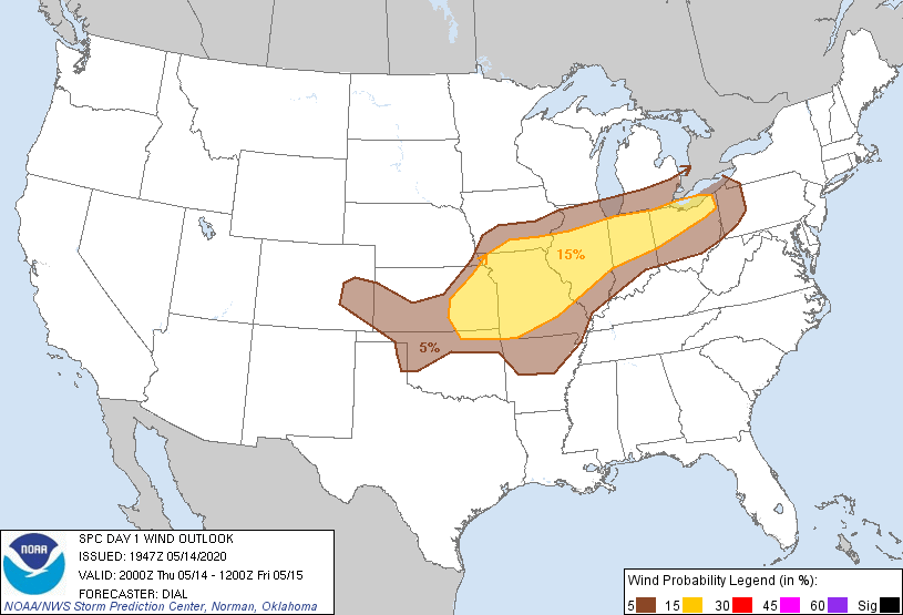
Probability of damaging thunderstorm winds or wind gusts of 50 knots or higher within 25 miles of a point. Hatched Area: 10% of greater probability of wind gusts 65 knots or greater within 25 miles of a point.
Day 1 Wind Risk
Area (sq. mi.)
Area Pop.
Some Larger Population Centers in Risk Area
15 %
168,396
21,529,367
Indianapolis, IN...Kansas City, MO...Cleveland, OH...Wichita, KS...St. Louis, MO...
SPC AC 141947
Day 1 Convective Outlook
NWS Storm Prediction Center Norman OK
0247 PM CDT Thu May 14 2020
Valid 142000Z - 151200Z
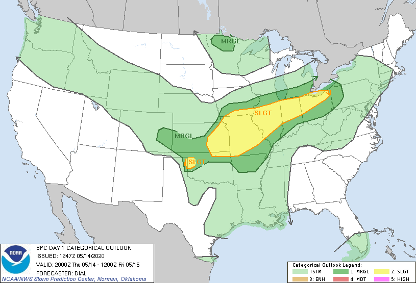
...THERE IS A SLIGHT RISK OF SEVERE THUNDERSTORMS EASTERN KANSAS
INTO THE OHIO VALLEY...AND IN THE VICINITY OF NORTHWEST OKLAHOMA...
...SUMMARY...
Isolated to scattered severe thunderstorms are possible later this
afternoon into tonight from eastern Kansas into the Ohio Valley, and
in the vicinity of northwest Oklahoma.
...Discussion...
Only minor adjustments have been made to previous forecast which
still appears on track.
..Dial.. 05/14/2020
.PREV DISCUSSION... /ISSUED 1130 AM CDT Thu May 14 2020/
...KS/MO to the OH Valley this afternoon through tonight...
A mainly zonal flow regime is present over the CONUS, with a
stronger belt of flow from the northern Great Basin to the upper MS
Valley and Great Lakes, and a more subtle southern stream across
AZ/NM. At the surface, a slow moving front extends
east-northeastward from a cyclone in west central KS to southern IA
and northern IL/IN. Overnight and ongoing convection has introduced
some convective outflow south of the front from northern MO into
central IL. Farther south in the open warm sector, remnant MCVs
from overnight convection are moving east-northeastward (now located
southwest of Tulsa and south of McAlester in eastern OK).
A belt of 25-35 kt southwesterly low-level flow will be maintained
through the afternoon from eastern OK into MO/IL/IN/OH, which will
support continued weak low-level warm advection and moisture
transport. Flow aloft will remain relatively weak with little
vertical shear above some low-level hodograph curvature. This
environment appears supportive of mainly multicell clusters and some
transient supercells along the front and residual outflow boundaries
this afternoon/evening from eastern KS into the OH Valley.
Convection will likely evolve into a larger band/line along the
front and the develop southeastward and southward overnight on
convective outflow. The stronger storms overnight will likely be
across MO/eastern KS, where a low-level jet will maintain an influx
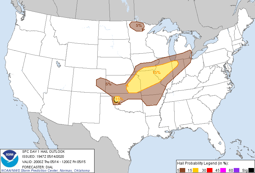
of richer moisture from the southern Plains. Occasional large hail
and damaging outflow winds will be the main threats with these
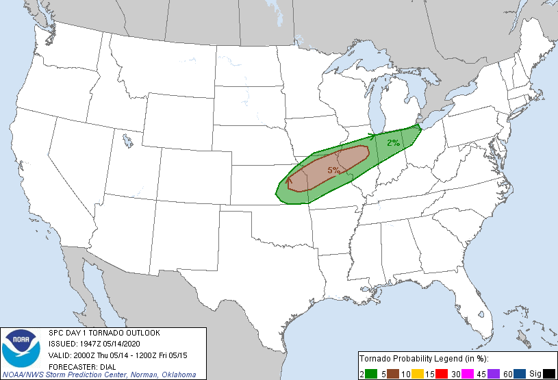
frontal storms later this afternoon into tonight. The tornado
threat is more questionable based on the relatively weak deep-layer
shear which will tend to limit storm longevity, and expected upscale
growth into a line.
...West central/northwest OK border region this evening...
The cold front/dryline triple point will likely sag southward to
near or south of Gage by late afternoon. Strong surface heating
near and south of the triple point will occur this afternoon, with
convective inhibition largely removed once surface temperatures
reach 88-90 F (per the 12z AMA sounding). Boundary-layer dewpoints
will likely mix into the upper 50s to lower 60s just east of the
dryline, but this will still support MLCAPE of 2500-3000 J/kg.
Isolated thunderstorm development will be possible near the triple
point this evening, by which time deep-layer vertical shear should
have increased some with the approach of embedded speed maxima from
AZ/NM. Relatively straight hodographs would favor splitting
supercells with a primary threat of large hail, prior to convection
weakening early tonight as convective inhibition increases.
...Northwest/north central MN this afternoon/evening...
A small midlevel low near the ND/MB border will move eastward to
northern MN this afternoon/evening, along with a weak surface
reflection. Boundary-layer dewpoints of 50-52 F and some surface
heating in proximity to the midlevel cold pool (-24 C at 500 mb)
could result in SBCAPE approaching 500 J/kg. The weak
destabilization in combination with ascent in advance of the
midlevel low and along an associated surface trough could support a
few low-topped thunderstorms with hail close to 1".
CLICK TO GET WUUS01 PTSDY1 PRODUCT
NOTE: THE NEXT DAY 1 OUTLOOK IS SCHEDULED BY 0100Z