|
| Mesoscale Discussion 1232 |
|
< Previous MD Next MD >
|
|
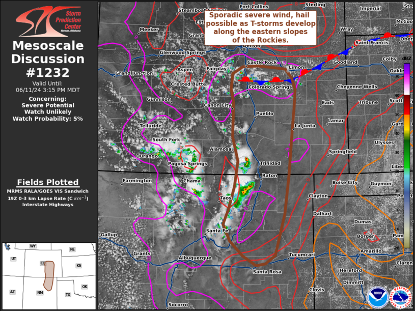
   Mesoscale Discussion 1232
   NWS Storm Prediction Center Norman OK
   0210 PM CDT Tue Jun 11 2024

   Areas affected...Northern New Mexico to central Colorado

   Concerning...Severe potential...Watch unlikely

   Valid 111910Z - 112115Z

   Probability of Watch Issuance...5 percent

   SUMMARY...Isolated thunderstorms may be capable of strong to severe
   downbursts, and perhaps large hail, this afternoon and evening along
   the eastern slopes of the CO/NM Rockies. Watch issuance is not
   expected.

   DISCUSSION...Isolated to scattered thunderstorms continue to develop
   within the higher terrain of the central Rockies from northern NM to
   central CO. Over the past 30 minutes, some of this activity has
   begun to propagate off the terrain towards the east/southeast as
   downstream buoyancy gradually increases. Some uptick in convective
   intensity is noted as well as, with additional thunderstorm
   development expected along and east of the central CO Front Range
   along a diffuse stationary boundary. Continued heating through late
   afternoon will result in deep boundary-layer mixing with 0-3 km
   lapse rates approaching 9 C/km - especially as temperatures climb
   into the low 80s. Despite somewhat meager buoyancy (MLCAPE forecast
   to only reach around 500 J/kg), forecast thermodynamic profiles
   should be supportive of strong downbursts that may produce sporadic
   wind gusts between 45-60 mph. A few stronger cells may be capable of
   hail approaching severe limits, especially near the stationary
   boundary where southeasterly low-level winds may support slightly
   stronger deep-layer shear and better storm organization. Given the
   overall meager kinematic environment and isolated nature of the
   threat, watch issuance is not expected.

   ..Moore/Smith.. 06/11/2024

   ...Please see www.spc.noaa.gov for graphic product...

   ATTN...WFO...PUB...BOU...ABQ...

   LAT...LON   35220406 35040432 35000457 35210493 35540527 35910546
               36230531 36720516 37280506 37810522 38570520 38860526
               39190523 39350495 39370453 39330407 39290376 39100357
               38850349 38460352 37950357 36960367 36120380 35220406
|
|
Top/All Mesoscale Discussions/Forecast Products/Home
|
|


 @NWSSPC