|
| Mesoscale Discussion 1231 |
|
< Previous MD Next MD >
|
|
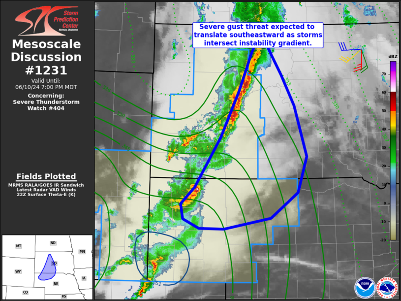
   Mesoscale Discussion 1231
   NWS Storm Prediction Center Norman OK
   0532 PM CDT Mon Jun 10 2024

   Areas affected...much of central South Dakota into northern Nebraska

   Concerning...Severe Thunderstorm Watch 404...

   Valid 102232Z - 110100Z

   The severe weather threat for Severe Thunderstorm Watch 404
   continues.

   SUMMARY...A threat of severe gusts and localized hail may spread
   east/southeast out of WW 404 into central South Dakota and northern
   Nebraska.

   DISCUSSION...A line of storms producing locally severe gusts has
   consolidated across west-central SD, with an additional cluster of
   cells over northwest NE. Merging/colliding outflows may aid further
   development from south-central SD into parts of northern NE this
   evening.

   Northeastern parts of the line have weakened recently as it has
   interacted with cooler air. Objective analysis and surface obs show
   a surface theta-e gradient just east of the existing watch, and
   given the northeast/southwest line orientation, the primary severe
   risk is forecast to translate southward over time, as new
   development prefers the warmer boundary layer. As such, a new watch
   may be considered.

   ..Jewell.. 06/10/2024

   ...Please see www.spc.noaa.gov for graphic product...

   ATTN...WFO...ABR...LBF...UNR...CYS...

   LAT...LON   42040275 42210317 42500323 42830287 43780220 44670173
               45400139 45600128 45600102 44980060 44390025 43429993
               42720017 42230088 42030210 42040275
|
|
Top/All Mesoscale Discussions/Forecast Products/Home
|
|


 @NWSSPC