Note:
The expiration time in the watch graphic is amended if the watch is
replaced, cancelled or extended.
Note:
Note:
The expiration time in the watch graphic is amended if the watch is
replaced, cancelled or extended.
Note: Click for
Watch Status Reports.
SEL4
URGENT - IMMEDIATE BROADCAST REQUESTED
Severe Thunderstorm Watch Number 404
NWS Storm Prediction Center Norman OK
1245 PM MDT Mon Jun 10 2024
The NWS Storm Prediction Center has issued a
* Severe Thunderstorm Watch for portions of
Far Southeast Montana
Far Southwest North Dakota
The Nebraska Panhandle
Western South Dakota
Eastern Wyoming
* Effective this Monday afternoon and evening from 1245 PM until
800 PM MDT.
* Primary threats include...
Scattered large hail and isolated very large hail events to 2
inches in diameter possible
Scattered damaging wind gusts to 70 mph possible
A tornado or two possible
SUMMARY...Thunderstorms will continue to strengthen this afternoon
and early evening while posing a threat for large hail around 1-2
inches in diameter and severe/damaging wind gusts of 60-70 mph. A
brief tornado may also occur with any sustained supercell,
especially in western South Dakota.
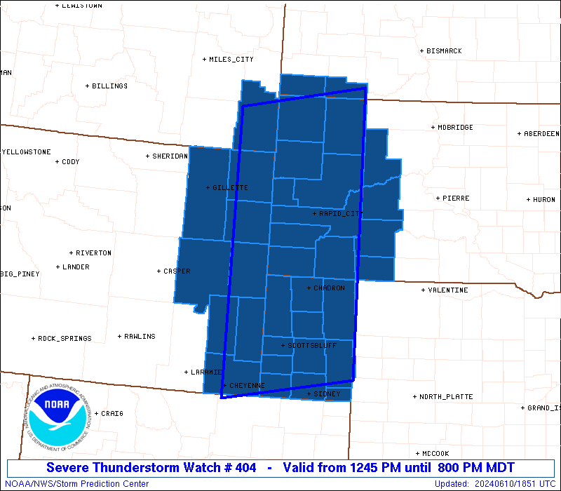
The severe thunderstorm watch area is approximately along and 165
statute miles north and south of a line from 95 miles north
northwest of Torrington WY to 55 miles east southeast of Rapid City
SD. For a complete depiction of the watch see the associated watch
outline update (WOUS64 KWNS WOU4).
PRECAUTIONARY/PREPAREDNESS ACTIONS...
REMEMBER...A Severe Thunderstorm Watch means conditions are
favorable for severe thunderstorms in and close to the watch area.
Persons in these areas should be on the lookout for threatening
weather conditions and listen for later statements and possible
warnings. Severe thunderstorms can and occasionally do produce
tornadoes.
&&
OTHER WATCH INFORMATION...CONTINUE...WW 403...
AVIATION...A few severe thunderstorms with hail surface and aloft to
2 inches. Extreme turbulence and surface wind gusts to 60 knots. A
few cumulonimbi with maximum tops to 500. Mean storm motion vector
27035.
...Gleason

   SEL4

   URGENT - IMMEDIATE BROADCAST REQUESTED
   Severe Thunderstorm Watch Number 404
   NWS Storm Prediction Center Norman OK
   1245 PM MDT Mon Jun 10 2024

   The NWS Storm Prediction Center has issued a

   * Severe Thunderstorm Watch for portions of
     Far Southeast Montana
     Far Southwest North Dakota
     The Nebraska Panhandle
     Western South Dakota
     Eastern Wyoming

   * Effective this Monday afternoon and evening from 1245 PM until
     800 PM MDT.

   * Primary threats include...
     Scattered large hail and isolated very large hail events to 2
       inches in diameter possible
     Scattered damaging wind gusts to 70 mph possible
     A tornado or two possible

   SUMMARY...Thunderstorms will continue to strengthen this afternoon
   and early evening while posing a threat for large hail around 1-2
   inches in diameter and severe/damaging wind gusts of 60-70 mph. A
   brief tornado may also occur with any sustained supercell,
   especially in western South Dakota.

   The severe thunderstorm watch area is approximately along and 165
   statute miles north and south of a line from 95 miles north
   northwest of Torrington WY to 55 miles east southeast of Rapid City
   SD. For a complete depiction of the watch see the associated watch
   outline update (WOUS64 KWNS WOU4).

   PRECAUTIONARY/PREPAREDNESS ACTIONS...

   REMEMBER...A Severe Thunderstorm Watch means conditions are
   favorable for severe thunderstorms in and close to the watch area.
   Persons in these areas should be on the lookout for threatening
   weather conditions and listen for later statements and possible
   warnings. Severe thunderstorms can and occasionally do produce
   tornadoes.

   &&

   OTHER WATCH INFORMATION...CONTINUE...WW 403...

   AVIATION...A few severe thunderstorms with hail surface and aloft to
   2 inches. Extreme turbulence and surface wind gusts to 60 knots. A
   few cumulonimbi with maximum tops to 500. Mean storm motion vector
   27035.

   ...Gleason
 Note:
The Aviation Watch (SAW) product is an approximation to the watch area.
The actual watch is depicted by the shaded areas.
Note:
The Aviation Watch (SAW) product is an approximation to the watch area.
The actual watch is depicted by the shaded areas.
   SAW4
   WW 404 SEVERE TSTM MT ND NE SD WY 101845Z - 110200Z
   AXIS..165 STATUTE MILES NORTH AND SOUTH OF LINE..
   95NNW TOR/TORRINGTON WY/ - 55ESE RAP/RAPID CITY SD/
   ..AVIATION COORDS.. 145NM N/S /63ENE DDY - 45ESE RAP/
   HAIL SURFACE AND ALOFT..2 INCHES. WIND GUSTS..60 KNOTS.
   MAX TOPS TO 500. MEAN STORM MOTION VECTOR 27035.

   LAT...LON 45720487 46130203 41350203 40930487

   THIS IS AN APPROXIMATION TO THE WATCH AREA.  FOR A
   COMPLETE DEPICTION OF THE WATCH SEE WOUS64 KWNS
   FOR WOU4.
Watch 404 Status Report Messages:
STATUS REPORT #5 ON WW 404

VALID 110010Z - 110140Z

SEVERE WEATHER THREAT CONTINUES RIGHT OF A LINE FROM 25 SW DGW TO
10 NW CDR TO 35 SSW PHP TO 20 W PIR.

..LYONS..06/11/24

ATTN...WFO...BYZ...BIS...CYS...LBF...UNR...

&&

STATUS REPORT FOR WS 404

SEVERE WEATHER THREAT CONTINUES FOR THE FOLLOWING AREAS

NEC005-007-013-031-033-045-049-069-075-091-101-105-123-157-161-
165-110140-

NE
.    NEBRASKA COUNTIES INCLUDED ARE

ARTHUR		     BANNER		 BOX BUTTE
CHERRY		     CHEYENNE		 DAWES
DEUEL		     GARDEN		 GRANT
HOOKER		     KEITH		 KIMBALL
MORRILL 	     SCOTTS BLUFF	 SHERIDAN
SIOUX
$$


SDC007-071-110140-

SD
.    SOUTH DAKOTA COUNTIES INCLUDED ARE

BENNETT 	     JACKSON
$$


WYC015-021-031-110140-

WY
.    WYOMING COUNTIES INCLUDED ARE

GOSHEN		     LARAMIE		 PLATTE
$$


THE WATCH STATUS MESSAGE IS FOR GUIDANCE PURPOSES ONLY.  PLEASE
REFER TO WATCH COUNTY NOTIFICATION STATEMENTS FOR OFFICIAL
INFORMATION ON COUNTIES...INDEPENDENT CITIES AND MARINE ZONES
CLEARED FROM SEVERE THUNDERSTORM AND TORNADO WATCHES.
$$

STATUS REPORT #4 ON WW 404

VALID 102230Z - 102340Z

SEVERE WEATHER THREAT CONTINUES RIGHT OF A LINE FROM 40 NE CPR TO
55 WSW RAP TO 30 NNE RAP TO 20 SSW Y22 TO 40 ESE DIK.

..LYONS..06/10/24

ATTN...WFO...BYZ...BIS...CYS...LBF...UNR...

&&

STATUS REPORT FOR WS 404

SEVERE WEATHER THREAT CONTINUES FOR THE FOLLOWING AREAS

NEC005-007-013-031-033-045-049-069-075-091-101-105-123-157-161-
165-102340-

NE
.    NEBRASKA COUNTIES INCLUDED ARE

ARTHUR		     BANNER		 BOX BUTTE
CHERRY		     CHEYENNE		 DAWES
DEUEL		     GARDEN		 GRANT
HOOKER		     KEITH		 KIMBALL
MORRILL 	     SCOTTS BLUFF	 SHERIDAN
SIOUX
$$


SDC007-033-047-055-071-093-102-103-105-137-102340-

SD
.    SOUTH DAKOTA COUNTIES INCLUDED ARE

BENNETT 	     CUSTER		 FALL RIVER
HAAKON		     JACKSON		 MEADE
OGLALA LAKOTA	     PENNINGTON 	 PERKINS
ZIEBACH
$$


WYC009-015-021-027-031-102340-

WY
.    WYOMING COUNTIES INCLUDED ARE

CONVERSE	     GOSHEN		 LARAMIE
NIOBRARA	     PLATTE
$$


THE WATCH STATUS MESSAGE IS FOR GUIDANCE PURPOSES ONLY.  PLEASE
REFER TO WATCH COUNTY NOTIFICATION STATEMENTS FOR OFFICIAL
INFORMATION ON COUNTIES...INDEPENDENT CITIES AND MARINE ZONES
CLEARED FROM SEVERE THUNDERSTORM AND TORNADO WATCHES.
$$

STATUS REPORT #3 ON WW 404

VALID 102135Z - 102240Z

SEVERE WEATHER THREAT CONTINUES RIGHT OF A LINE FROM 15 NNW 4BQ
TO 30 SE 4BQ TO 40 SW 2WX TO 20 SSE 2WX TO 35 E 2WX TO 30 N Y22.

..LYONS..06/10/24

ATTN...WFO...BYZ...BIS...CYS...LBF...UNR...

&&

STATUS REPORT FOR WS 404

SEVERE WEATHER THREAT CONTINUES FOR THE FOLLOWING AREAS

NEC007-013-033-045-049-069-105-123-157-161-165-102240-

NE
.    NEBRASKA COUNTIES INCLUDED ARE

BANNER		     BOX BUTTE		 CHEYENNE
DAWES		     DEUEL		 GARDEN
KIMBALL 	     MORRILL		 SCOTTS BLUFF
SHERIDAN	     SIOUX
$$


SDC007-019-033-047-055-071-081-093-102-103-105-137-102240-

SD
.    SOUTH DAKOTA COUNTIES INCLUDED ARE

BENNETT 	     BUTTE		 CUSTER
FALL RIVER	     HAAKON		 JACKSON
LAWRENCE	     MEADE		 OGLALA LAKOTA
PENNINGTON	     PERKINS		 ZIEBACH
$$


WYC009-011-015-021-027-031-045-102240-

WY
.    WYOMING COUNTIES INCLUDED ARE

CONVERSE	     CROOK		 GOSHEN
LARAMIE 	     NIOBRARA		 PLATTE
WESTON
$$


THE WATCH STATUS MESSAGE IS FOR GUIDANCE PURPOSES ONLY.  PLEASE
REFER TO WATCH COUNTY NOTIFICATION STATEMENTS FOR OFFICIAL
INFORMATION ON COUNTIES...INDEPENDENT CITIES AND MARINE ZONES
CLEARED FROM SEVERE THUNDERSTORM AND TORNADO WATCHES.
$$

STATUS REPORT #2 ON WW 404

VALID 102100Z - 102240Z

THE SEVERE WEATHER THREAT CONTINUES ACROSS THE ENTIRE WATCH AREA.

..LYONS..06/10/24

ATTN...WFO...BYZ...BIS...CYS...LBF...UNR...

&&

STATUS REPORT FOR WS 404

SEVERE WEATHER THREAT CONTINUES FOR THE FOLLOWING AREAS

MTC011-102240-

MT
.    MONTANA COUNTIES INCLUDED ARE

CARTER
$$


NEC007-013-033-045-049-069-105-123-157-161-165-102240-

NE
.    NEBRASKA COUNTIES INCLUDED ARE

BANNER		     BOX BUTTE		 CHEYENNE
DAWES		     DEUEL		 GARDEN
KIMBALL 	     MORRILL		 SCOTTS BLUFF
SHERIDAN	     SIOUX
$$


NDC001-011-102240-

ND
.    NORTH DAKOTA COUNTIES INCLUDED ARE

ADAMS		     BOWMAN
$$


SDC007-019-033-047-055-063-071-081-093-102-103-105-137-102240-

SD
.    SOUTH DAKOTA COUNTIES INCLUDED ARE

BENNETT 	     BUTTE		 CUSTER
FALL RIVER	     HAAKON		 HARDING
JACKSON 	     LAWRENCE		 MEADE
OGLALA LAKOTA	     PENNINGTON 	 PERKINS
ZIEBACH
$$


WYC005-009-011-015-021-027-031-045-102240-

WY
.    WYOMING COUNTIES INCLUDED ARE

CAMPBELL	     CONVERSE		 CROOK
GOSHEN		     LARAMIE		 NIOBRARA
PLATTE		     WESTON
$$


THE WATCH STATUS MESSAGE IS FOR GUIDANCE PURPOSES ONLY.  PLEASE
REFER TO WATCH COUNTY NOTIFICATION STATEMENTS FOR OFFICIAL
INFORMATION ON COUNTIES...INDEPENDENT CITIES AND MARINE ZONES
CLEARED FROM SEVERE THUNDERSTORM AND TORNADO WATCHES.
$$

STATUS REPORT #1 ON WW 404

VALID 101935Z - 102040Z

THE SEVERE WEATHER THREAT CONTINUES ACROSS THE ENTIRE WATCH AREA.

..LYONS..06/10/24

ATTN...WFO...BYZ...BIS...CYS...LBF...UNR...

&&

STATUS REPORT FOR WS 404

SEVERE WEATHER THREAT CONTINUES FOR THE FOLLOWING AREAS

MTC011-102040-

MT
.    MONTANA COUNTIES INCLUDED ARE

CARTER
$$


NEC007-013-033-045-049-069-105-123-157-161-165-102040-

NE
.    NEBRASKA COUNTIES INCLUDED ARE

BANNER		     BOX BUTTE		 CHEYENNE
DAWES		     DEUEL		 GARDEN
KIMBALL 	     MORRILL		 SCOTTS BLUFF
SHERIDAN	     SIOUX
$$


NDC001-011-102040-

ND
.    NORTH DAKOTA COUNTIES INCLUDED ARE

ADAMS		     BOWMAN
$$


SDC007-019-033-047-055-063-071-081-093-102-103-105-137-102040-

SD
.    SOUTH DAKOTA COUNTIES INCLUDED ARE

BENNETT 	     BUTTE		 CUSTER
FALL RIVER	     HAAKON		 HARDING
JACKSON 	     LAWRENCE		 MEADE
OGLALA LAKOTA	     PENNINGTON 	 PERKINS
ZIEBACH
$$


WYC005-009-011-015-021-027-031-045-102040-

WY
.    WYOMING COUNTIES INCLUDED ARE

CAMPBELL	     CONVERSE		 CROOK
GOSHEN		     LARAMIE		 NIOBRARA
PLATTE		     WESTON
$$


THE WATCH STATUS MESSAGE IS FOR GUIDANCE PURPOSES ONLY.  PLEASE
REFER TO WATCH COUNTY NOTIFICATION STATEMENTS FOR OFFICIAL
INFORMATION ON COUNTIES...INDEPENDENT CITIES AND MARINE ZONES
CLEARED FROM SEVERE THUNDERSTORM AND TORNADO WATCHES.
$$
Note:
Click for Complete Product Text.
Tornadoes
Probability of 2 or more tornadoes
|
Low (20%)
|
Probability of 1 or more strong (EF2-EF5) tornadoes
|
Low (10%)
|
Wind
Probability of 10 or more severe wind events
|
Mod (50%)
|
Probability of 1 or more wind events > 65 knots
|
Low (20%)
|
Hail
Probability of 10 or more severe hail events
|
Mod (50%)
|
Probability of 1 or more hailstones > 2 inches
|
Mod (30%)
|
Combined Severe Hail/Wind
Probability of 6 or more combined severe hail/wind events
|
High (80%)
|
For each watch, probabilities for particular events inside the watch
(listed above in each table) are determined by the issuing forecaster.
The "Low" category contains probability values ranging from less than 2%
to 20% (EF2-EF5 tornadoes), less than 5% to 20% (all other probabilities),
"Moderate" from 30% to 60%, and "High" from 70% to greater than 95%.
High values are bolded and lighter in color to provide awareness of
an increased threat for a particular event.


 @NWSSPC