|
| Mesoscale Discussion 1229 |
|
< Previous MD Next MD >
|

|
   Mesoscale Discussion 1229
   NWS Storm Prediction Center Norman OK
   0353 PM CDT Mon Jun 10 2024

   Areas affected...Eastern Wyoming into western South Dakota and the
   Nebraska Panhandle

   Concerning...Severe Thunderstorm Watch 404...

   Valid 102053Z - 102300Z

   The severe weather threat for Severe Thunderstorm Watch 404
   continues.

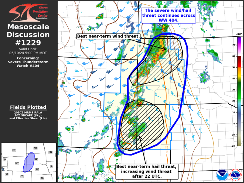
   SUMMARY...The threat for severe wind/hail continues across the
   northern High Plains with more focused corridors of greater
   wind/hail potential noted based on recent observed trends across
   northwest South Dakota and southeastern Wyoming into the Nebraska
   Panhandle.

   DISCUSSION...Over the past hour, an organized squall line has
   emerged from a cluster of initially semi-discrete cells across
   northwest SD. This line has a history of producing severe wind,
   including a measured 66 mph gust. This line will continue to pose a
   severe wind risk through the eastern edge of WW 404; however,
   downstream into central SD, lower quality moisture/buoyancy should
   result in a gradual weakening trend through the late afternoon/early
   evening. Some indications of this weakening have already been noted
   as portions of the line are slowly becoming outflow dominant.
   Downstream watch issuance does not appear likely at this time, but
   convective trends will continue to be monitored to ensure the line
   weakens as expected as it exits WW 404.

   Further south, a cluster of semi-discrete cells continues to move
   east along the front. MRMS hail estimates suggests the more intense
   cells have been capable of large to very large hail (possibly up to
   2 inches in diameter). The expectation over the next hour or so is
   for these semi-discrete cells to continue to pose a large hail risk
   as they migrate towards an axis of greater (2000-2500 J/kg) SBCAPE.
   Continued thunderstorm development along the front should favor a
   gradual transition to an organized line with an increasing wind
   threat. When this transition occurs remains somewhat unclear, but
   most indications suggest this may occur around or just after 22 UTC
   across far southwest SD and the NE Panhandle.

   ..Moore.. 06/10/2024

   ...Please see www.spc.noaa.gov for graphic product...

   ATTN...WFO...ABR...BIS...LBF...UNR...BOU...CYS...

   LAT...LON   40760474 40920503 41240519 42380502 43210460 44120464
               44460436 45020372 45430340 45760320 45990299 46140255
               46150178 46050135 45870106 45550092 45140090 44190105
               43850114 42440150 41510236 41210283 41060330 40750437
               40760474
|
|
Top/All Mesoscale Discussions/Forecast Products/Home
|
|


