|
| Mesoscale Discussion 1228 |
|
< Previous MD Next MD >
|
|
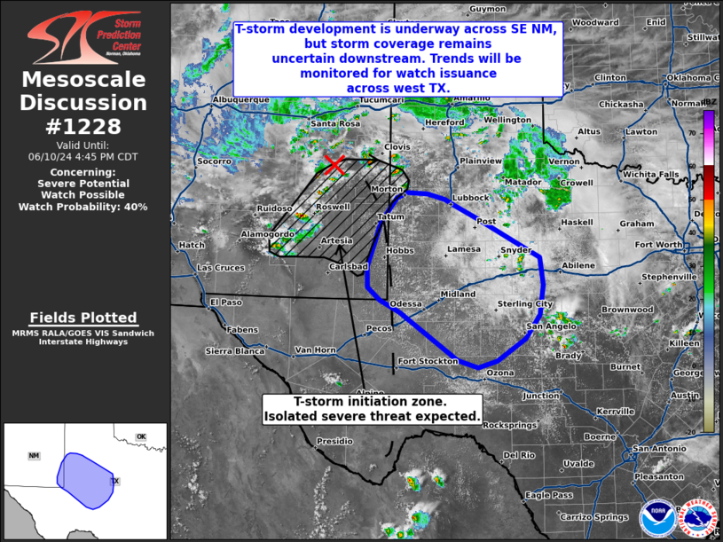
   Mesoscale Discussion 1228
   NWS Storm Prediction Center Norman OK
   0216 PM CDT Mon Jun 10 2024

   Areas affected...Southeast New Mexico to western Texas

   Concerning...Severe potential...Watch possible

   Valid 101916Z - 102145Z

   Probability of Watch Issuance...40 percent

   SUMMARY...Isolated to scattered thunderstorm development is underway
   across southeast New Mexico and far western Texas. Initially
   discrete cells will likely pose a severe hail/wind risk across
   southeast New Mexico before gradual upscale growth later this
   afternoon/evening into western Texas. Convective coverage remains
   uncertain, but trends will be monitored for the need for watch
   issuance across portions of west Texas.

   DISCUSSION...Latest regional radar imagery show early thunderstorm
   development across far southeast NM into far western TX along a
   weak/diffuse low-level confluence axis, as well as within upslope
   flow regime on the eastern side of the Sacramento Mountains.
   Additional thunderstorm development is anticipated through late
   afternoon as temperatures climb into the low/mid 80s and MLCIN
   continues to wane. Initial cells will likely be isolated, and may
   remain fairly weak given more marginal moisture/buoyancy within this
   initiation zone. However, 30-knot mid-level flow on the southern
   fringe of a weak mid-level vorticity maximum is elongating
   hodographs through 5 to 6 km AGL, which may support storm
   organization with an attendant severe hail/wind risk.

   Thunderstorms should intensify as they migrate downstream into the
   southern Permian Basin and northern Edwards Plateau where higher
   quality low-level moisture is noted in 19 UTC surface observations
   (dewpoints in the low to mid 60s). Discrete cells that can meander
   into this air mass may pose a more robust hail threat as they fully
   realize more substantial effective bulk shear (between 35-40 knots).
   However, given a somewhat deep (around 2 km), well-mixed boundary
   layer and weak low-level storm relative winds, storms may have a
   high probability of becoming outflow dominant within the first
   couple of hours. Upscale growth into a more organized cluster/line
   appears possible, but may be conditional on the coverage of initial
   cells (which remains uncertain). If this scenario occurs, a more
   focused wind threat may materialize downstream across parts of the
   Permian Basin/Edwards Plateau later this evening. Trends will
   continue to be monitored for the need for watch issuance as storm
   coverage becomes more apparent.

   ..Moore/Gleason.. 06/10/2024

   ...Please see www.spc.noaa.gov for graphic product...

   ATTN...WFO...SJT...LUB...MAF...

   LAT...LON   31780282 31990321 32200345 32530346 32940332 33250321
               33660289 33750270 33740229 33640196 33540176 33350136
               32680012 32240005 31750012 31360040 31000095 30880131
               31000171 31780282
|
|
Top/All Mesoscale Discussions/Forecast Products/Home
|
|


 @NWSSPC