|
| Mesoscale Discussion 1227 |
|
Next MD >
|
|
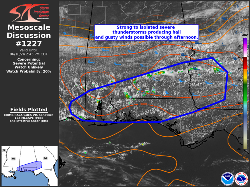
   Mesoscale Discussion 1227
   NWS Storm Prediction Center Norman OK
   1250 PM CDT Mon Jun 10 2024

   Areas affected...far southern MS into southern AL...southwest
   GA...and parts of the FL Panhandle

   Concerning...Severe potential...Watch unlikely

   Valid 101750Z - 101945Z

   Probability of Watch Issuance...20 percent

   SUMMARY...Strong to isolated severe thunderstorms are possible
   through the afternoon. Strong gusts and marginally severe hail are
   possible with the strongest storms.

   DISCUSSION...Isolated strong to severe thunderstorms are expected to
   continue developing through the afternoon in the vicinity of a
   stationary surface boundary draped across the region. Large-scale
   ascent is expected to remain weak and low-level convergence limited.
   However, strong heating surface dewpoints generally in the low 70s
   is resulting in MLCAPE values to 2500 J/kg. Deep-layer flow will
   remain mostly unidirectional from the west/southwest and also fairly
   weak through 4-5 km. Strengthening flow from about 500 mb upwards
   will however support effective shear magnitudes around 25-30 kt.
   Forecast soundings show elongated hodographs, and a brief/transient
   supercell or two will be possible with better organized convection.
   Overall this environment should support thunderstorms capable of
   gusts from 45-60 mph and hail to near 1 inch diameter. A watch
   probably will not be needed given overall marginal nature of the
   parameter space, but convective trends will be monitored.

   ..Leitman/Gleason.. 06/10/2024

   ...Please see www.spc.noaa.gov for graphic product...

   ATTN...WFO...FFC...TAE...BMX...MOB...LIX...

   LAT...LON   31198830 31978530 32108433 31698385 30948397 30608500
               30338605 30318747 30368851 30538885 30708893 30878888
               31198830
|
|
Top/All Mesoscale Discussions/Forecast Products/Home
|
|


 @NWSSPC