|
| Mesoscale Discussion 1226 |
|
< Previous MD Next MD >
|
|
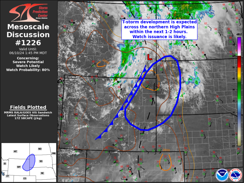
   Mesoscale Discussion 1226
   NWS Storm Prediction Center Norman OK
   1246 PM CDT Mon Jun 10 2024

   Areas affected...Eastern Wyoming into western South Dakota

   Concerning...Severe potential...Watch likely

   Valid 101746Z - 101945Z

   Probability of Watch Issuance...80 percent

   SUMMARY...Thunderstorm development along a cold front is anticipated
   within the next 1-2 hours across parts of the northern High Plains.
   Initially discrete cells will pose a severe hail/wind, and perhaps a
   tornado, risk before eventual upscale growth later this evening.
   Watch issuance will likely be needed given favorable environmental
   wind shear and improving buoyancy.

   DISCUSSION...Recent GOES visible imagery and surface observations
   show the eastward progression of a low to mid-level cold front
   across the northern Rockies into the northern High Plains over the
   past few hours. Thunderstorm development is expected along this
   boundary as it impinges on the western fringe of returning low-level
   moisture across WY/NE/SD (where dewpoints are climbing into the mid
   to upper 50s). This somewhat high moisture content (dewpoints are
   near the 90th percentile for the northern High Plains for early/mid
   June) overlaid with 7-8 C/km mid-level lapse rates should support
   MLCAPE near 2000 J/kg across the region by mid-afternoon as
   thunderstorms develop and/or mature.

   Deep-layer flow orthogonal to the front should support initially
   discrete cells, including the potential for a few supercells, with
   an attendant large hail (possibly up to 2 inches in diameter),
   severe wind, and perhaps a brief tornado threat - especially across
   northwestern SD where low-level winds are more south/southeasterly
   ahead of a diffuse surface trough. Strong frontal forcing should
   foster a gradual upscale growth into one or more semi-organized
   clusters or lines with an attendant increase in the severe wind
   potential. Watch issuance will be needed within the next hour or so
   to address these concerns.

   ..Moore/Gleason.. 06/10/2024

   ...Please see www.spc.noaa.gov for graphic product...

   ATTN...WFO...BIS...UNR...CYS...BYZ...RIW...

   LAT...LON   43310636 44370548 45280482 45750430 46180334 46210291
               45950242 45280220 44470221 43630251 42970296 42580354
               42330413 42180466 42190518 42370564 42500593 42810628
               42930635 43310636
|
|
Top/All Mesoscale Discussions/Forecast Products/Home
|
|


 @NWSSPC