|
| Mesoscale Discussion 1225 |
|
< Previous MD
|
|
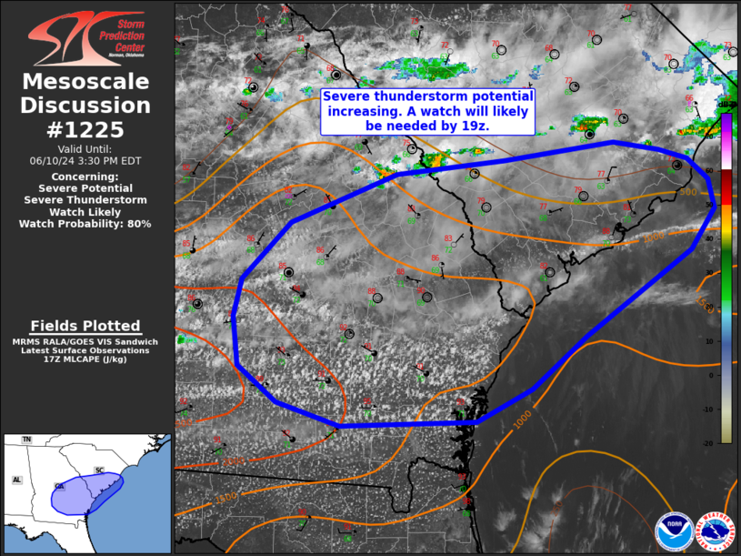
   Mesoscale Discussion 1225
   NWS Storm Prediction Center Norman OK
   1231 PM CDT Mon Jun 10 2024

   Areas affected...southeast GA into extreme southern SC

   Concerning...Severe potential...Severe Thunderstorm Watch likely

   Valid 101731Z - 101930Z

   Probability of Watch Issuance...80 percent

   SUMMARY...Severe thunderstorms capable of hail to 2 inch diameter
   and gusts to 65 mph are expected to develop over the next 1-2 hours.
   A Severe Thunderstorm Watch is expected by 19z.

   DISCUSSION...Strong heating has allowed for inhibition to rapidly
   erode early this afternoon. Widespread vertically developing cumulus
   is noted where skies have remained mostly clear across
   southern/central GA. Development is a bit slower further east into
   SC where thin cloud cover has mildly muted heating. Regardless,
   another 1-2 hours of heating will result continued erosion of
   inhibition downstream.

   Surface dewpoints in the upper 60s to low 70s F amid modest midlevel
   lapse rates of 6.5-7 C/km is resulting in moderate destabilization
   from west to east along a surface boundary. While deep-layer flow
   will remain mostly unidirectional from the southwest, increasing
   speed with height is supporting elongated, somewhat straight
   hodographs, and effective shear magnitudes greater than 35 kt. This
   environment will support supercells storms capable of large hail.
   With time, convective coverage should become quite widespread and
   clustering my further enhance strong/severe wind gust potential.
   Convection should develop/increase in coverage by 19-20z and a watch
   will likely be needed in the next hour or so.

   ..Leitman/Gleason.. 06/10/2024

   ...Please see www.spc.noaa.gov for graphic product...

   ATTN...WFO...ILM...CHS...CAE...JAX...FFC...TAE...

   LAT...LON   32348374 32838325 33248218 33368107 33517997 33457951
               33367922 33187900 32947895 32587918 31868025 31418081
               31138136 31098273 31288337 31608376 32018382 32348374
|
|
Top/All Mesoscale Discussions/Forecast Products/Home
|
|


 @NWSSPC