|
| Mesoscale Discussion 1219 |
|
< Previous MD Next MD >
|
|
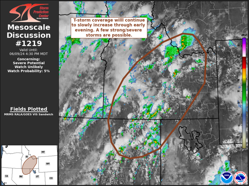
   Mesoscale Discussion 1219
   NWS Storm Prediction Center Norman OK
   0332 PM CDT Sun Jun 09 2024

   Areas affected...Northeast Nevada to central Idaho and far southwest
   Montana

   Concerning...Severe potential...Watch unlikely

   Valid 092032Z - 092230Z

   Probability of Watch Issuance...5 percent

   SUMMARY...Thunderstorms will continue to increase in coverage
   through early evening across northeastern Nevada into Idaho and far
   southwest Montana. Sporadic hail and damaging to severe winds are
   possible, but this threat should remain sufficiently isolated to
   preclude watch issuance.

   DISCUSSION...Over the past hour, widely scattered thunderstorms have
   developed across the northern Great Basin into the northern Rockies.
   GOES daytime RGB imagery shows multiple agitated cumulus fields from
   central NV into central ID as ascent overspreads the region ahead of
   a mid-level disturbance over central NV and a more prominent
   shortwave trough approaching the Cascades. Additionally, regional
   temperatures continue to generally rise into the low to mid 80s,
   which should be sufficient to erode any lingering inhibition.
   These trends suggest that additional thunderstorm development is
   likely within the next couple of hours.

   MRMS echo top and vertical ice data show that most cells have been
   relatively transient, but a few more robust updrafts have persisted
   across northern NV ahead of the mid-level disturbance. The KCBX VWP
   has recently sampled 25-35 knot winds between 5-6 km, suggesting
   that the better kinematic environment resides across northern NV to
   central ID. This region also has slightly better moisture content
   (GOES-estimated PWAT values between 0.8-1.0 inch) compared to the
   rest of the region. Consequently, storms developing in or migrating
   into this region may see the highest potential for large hail and
   severe wind given the better thermodynamic and kinematic
   environment. Severe wind may be the more probable of the two hazards
   given somewhat modest buoyancy profiles within the hail production
   layer and modest hodograph elongation compared to 8-9 C/km lapse
   rates from the surface to 3 km AGL and the increasing potential for
   storm interactions/upscale growth through early evening as
   additional convection develops. This idea appears to be well
   supported by high-res probabilistic hazard guidance, though the
   overall coverage of the severe threat should remain sufficiently low
   to preclude watch issuance.

   ..Moore/Gleason.. 06/09/2024

   ...Please see www.spc.noaa.gov for graphic product...

   ATTN...WFO...TFX...SLC...PIH...MSO...BOI...LKN...

   LAT...LON   41371360 40861412 40551495 40471560 40621614 41081654
               41921675 42841648 43541601 44201527 44981389 45291283
               45251228 44981195 44501159 43371172 41961298 41371360
|
|
Top/All Mesoscale Discussions/Forecast Products/Home
|
|


 @NWSSPC