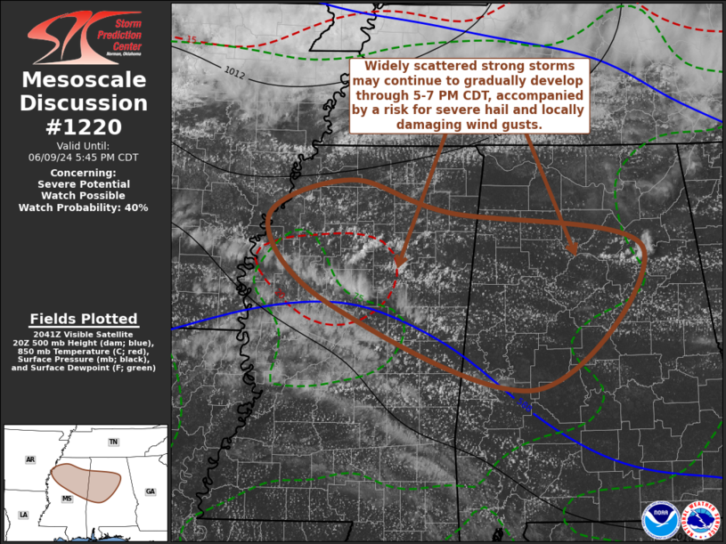
   Mesoscale Discussion 1220
   NWS Storm Prediction Center Norman OK
   0347 PM CDT Sun Jun 09 2024

   Areas affected...parts of northern Mississippi through central
   Alabama

   Concerning...Severe potential...Watch possible

   Valid 092047Z - 092245Z

   Probability of Watch Issuance...40 percent

   SUMMARY...Widely scattered strong thunderstorms, including at least
   short-lived supercell structures, may continue to gradually develop
   through 5-7 PM CDT, accompanied by a risk for severe hail and
   locally damaging wind gusts.  It is not clear that a severe weather
   watch will be needed, but trends are being monitored.

   DISCUSSION...Beneath a remnant plume of elevated mixed-layer air
   which has advected across and east-southeast of the lower
   Mississippi Valley, surface temperatures are warming through the
   lower/mid 90s F.  Within a seasonably moist boundary layer, it
   appears that this is contributing to large CAPE up to 2500-3000
   J/kg, near the southern periphery of stronger west-northwesterly
   mid/upper flow (including 35-45 kt around 500 mb).

   Although much of the region appears south of the stronger mid/upper
   forcing for ascent, deepening convection, including at least a few
   attempts at sustained thunderstorm development, appear to be
   underway.  With at least some further erosion of inhibition with
   continuing insolation, it appears that this may continue with widely
   scattered intensifying thunderstorms possible through late
   afternoon.  Although low-level wind fields and hodographs are rather
   weak, deep-layer shear appears supportive of appreciable mid-level
   rotation and the occasional evolution of supercell structures posing
   a risk for severe hail and locally damaging wind gusts.

   ..Kerr/Gleason.. 06/09/2024

   ...Please see www.spc.noaa.gov for graphic product...

   ATTN...WFO...BMX...HUN...MEG...JAN...

   LAT...LON   34628980 34298856 33898607 32398745 33319006 34209086
               34628980
|


 @NWSSPC