|
| Mesoscale Discussion 1190 |
|
< Previous MD Next MD >
|
|
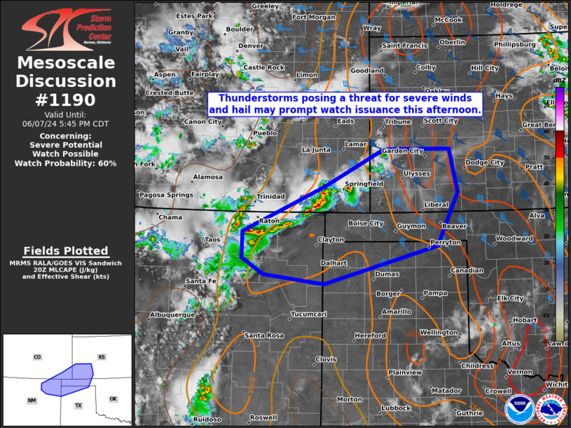
   Mesoscale Discussion 1190
   NWS Storm Prediction Center Norman OK
   0340 PM CDT Fri Jun 07 2024

   Areas affected...Portions of northeast NM...southeast CO...southwest
   KS...and the OK/TX Panhandles

   Concerning...Severe potential...Watch possible

   Valid 072040Z - 072245Z

   Probability of Watch Issuance...60 percent

   SUMMARY...Thunderstorms posing a threat for severe winds and hail
   may prompt watch issuance this afternoon.

   DISCUSSION...Convection has recently increased in coverage and
   intensity across the southern/central High Plains along/near a
   surface trough. A rather hot and well-mixed airmass is present
   along/ahead of this activity, as robust daytime heating has allowed
   surface temperatures to reach into the 90s and lower 100s.
   Severe/damaging winds will probably be the main threat with this
   activity as it spreads east-southeastward through the rest of the
   afternoon, and continuing into the early evening. Some of these wind
   gusts could be significant (75+ mph) given very large
   temperature-dewpoint spreads from recent surface observations and
   near-dry adiabatic lapse rates through low/mid levels. Stronger
   deep-layer shear over southeast CO into southwest KS may support
   some threat for a supercell or two, with associated risk for large
   hail in addition to the severe/damaging wind threat. Given current
   observational trends, a Severe Thunderstorm Watch may be needed to
   address this increasing severe risk.

   ..Gleason/Guyer.. 06/07/2024

   ...Please see www.spc.noaa.gov for graphic product...

   ATTN...WFO...DDC...AMA...PUB...ABQ...

   LAT...LON   36650475 37430301 38070174 38070034 37330017 36410061
               35760301 35930429 36210476 36650475
|
|
Top/All Mesoscale Discussions/Forecast Products/Home
|
|


 @NWSSPC