|
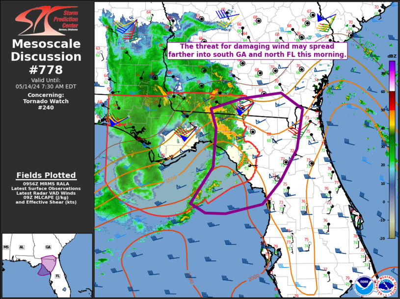
| Mesoscale Discussion 778 |
|
< Previous MD Next MD >
|
|
   Mesoscale Discussion 0778
   NWS Storm Prediction Center Norman OK
   0458 AM CDT Tue May 14 2024

   Areas affected...North FL into south GA

   Concerning...Tornado Watch 240...

   Valid 140958Z - 141130Z

   The severe weather threat for Tornado Watch 240 continues.

   SUMMARY...Some threat for isolated damaging wind may spread farther
   into south Georgia and north Florida this morning.

   DISCUSSION...A band of convection that earlier developed along the
   periphery of a weakening MCS is now moving eastward, to the east of
   the Tallahassee area. While this convection is rather vigorous, with
   some cooling cloud tops noted in IR imagery, it remains rather
   disorganized at this time. However, with MLCAPE of 500-1000 J/kg and
   moderate deep-layer shear across the region, further organization of
   this convective band remains possible with time. If this occurs,
   some threat for damaging wind will spread farther into south GA and
   north FL, especially if the convective band can merge with new
   convection that has recently developed to its immediate south and
   southeast.

   The need for short-term watch issuance downstream of WW 240 remains
   uncertain, and will depend on short-term trends regarding intensity
   and organization of the ongoing cluster. Potential remains for an
   upstream cluster of storms (currently over the north-central Gulf of
   Mexico) to eventually move across the area later this morning, which
   could also pose a severe risk.

   ..Dean/Guyer.. 05/14/2024

   ...Please see www.spc.noaa.gov for graphic product...

   ATTN...WFO...TBW...JAX...TAE...

   LAT...LON   29948200 29318238 28848281 28658364 28668411 28848445
               29588393 30368388 30768400 30968328 31078237 30758186
               29948200
|
|
Top/All Mesoscale Discussions/Forecast Products/Home
|
|


 @NWSSPC