Note:
The expiration time in the watch graphic is amended if the watch is
replaced, cancelled or extended.
Note:
Note:
The expiration time in the watch graphic is amended if the watch is
replaced, cancelled or extended.
Note: Click for
Watch Status Reports.
SEL0
URGENT - IMMEDIATE BROADCAST REQUESTED
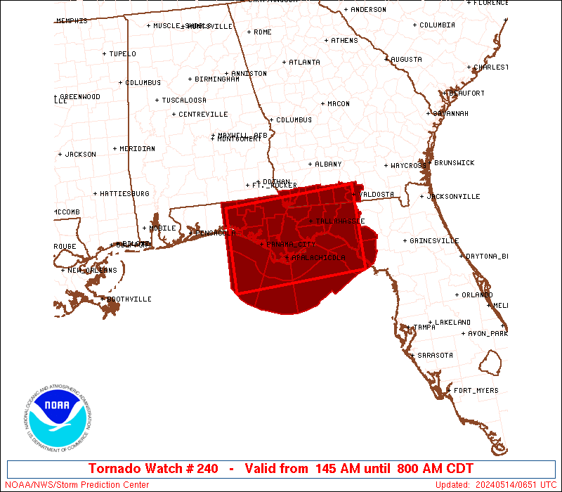
Tornado Watch Number 240
NWS Storm Prediction Center Norman OK
145 AM CDT Tue May 14 2024
The NWS Storm Prediction Center has issued a
* Tornado Watch for portions of
Northern Florida
Far Southern Georgia
Coastal Waters
* Effective this Tuesday morning from 145 AM until 800 AM CDT.
* Primary threats include...
A couple tornadoes possible
Scattered damaging wind gusts to 70 mph possible
SUMMARY...A well-organized complex of storms over the northeast Gulf
of Mexico will move into the Florida Panhandle and other parts of
northern Florida, and eventually far southern Georgia, through the
early morning hours. Severe/tornado potential is expected to
increase as the atmosphere ahead of these storms further
destabilizes.
The tornado watch area is approximately along and 60 statute miles
north and south of a line from 40 miles west southwest of Panama
City FL to 45 miles south of Valdosta GA. For a complete depiction
of the watch see the associated watch outline update (WOUS64 KWNS
WOU0).
PRECAUTIONARY/PREPAREDNESS ACTIONS...
REMEMBER...A Tornado Watch means conditions are favorable for
tornadoes and severe thunderstorms in and close to the watch
area. Persons in these areas should be on the lookout for
threatening weather conditions and listen for later statements
and possible warnings.
&&
AVIATION...Tornadoes and a few severe thunderstorms with hail
surface and aloft to 1.5 inches. Extreme turbulence and surface wind
gusts to 60 knots. A few cumulonimbi with maximum tops to 550. Mean
storm motion vector 26035.
...Guyer

   SEL0

   URGENT - IMMEDIATE BROADCAST REQUESTED
   Tornado Watch Number 240
   NWS Storm Prediction Center Norman OK
   145 AM CDT Tue May 14 2024

   The NWS Storm Prediction Center has issued a

   * Tornado Watch for portions of
     Northern Florida
     Far Southern Georgia
     Coastal Waters

   * Effective this Tuesday morning from 145 AM until 800 AM CDT.

   * Primary threats include...
     A couple tornadoes possible
     Scattered damaging wind gusts to 70 mph possible

   SUMMARY...A well-organized complex of storms over the northeast Gulf
   of Mexico will move into the Florida Panhandle and other parts of
   northern Florida, and eventually far southern Georgia, through the
   early morning hours. Severe/tornado potential is expected to
   increase as the atmosphere ahead of these storms further
   destabilizes.

   The tornado watch area is approximately along and 60 statute miles
   north and south of a line from 40 miles west southwest of Panama
   City FL to 45 miles south of Valdosta GA. For a complete depiction
   of the watch see the associated watch outline update (WOUS64 KWNS
   WOU0).

   PRECAUTIONARY/PREPAREDNESS ACTIONS...

   REMEMBER...A Tornado Watch means conditions are favorable for
   tornadoes and severe thunderstorms in and close to the watch
   area. Persons in these areas should be on the lookout for
   threatening weather conditions and listen for later statements
   and possible warnings.

   &&

   AVIATION...Tornadoes and a few severe thunderstorms with hail
   surface and aloft to 1.5 inches. Extreme turbulence and surface wind
   gusts to 60 knots. A few cumulonimbi with maximum tops to 550. Mean
   storm motion vector 26035.

   ...Guyer
 Note:
The Aviation Watch (SAW) product is an approximation to the watch area.
The actual watch is depicted by the shaded areas.
Note:
The Aviation Watch (SAW) product is an approximation to the watch area.
The actual watch is depicted by the shaded areas.
   SAW0
   WW 240 TORNADO FL GA CW 140645Z - 141300Z
   AXIS..60 STATUTE MILES NORTH AND SOUTH OF LINE..
   40WSW PFN/PANAMA CITY FL/ - 45S VLD/VALDOSTA GA/
   ..AVIATION COORDS.. 50NM N/S /54SSE CEW - 34NNW CTY/
   HAIL SURFACE AND ALOFT..1.5 INCHES. WIND GUSTS..60 KNOTS.
   MAX TOPS TO 550. MEAN STORM MOTION VECTOR 26035.

   LAT...LON 30878630 31008328 29268328 29138630

   THIS IS AN APPROXIMATION TO THE WATCH AREA.  FOR A
   COMPLETE DEPICTION OF THE WATCH SEE WOUS64 KWNS
   FOR WOU0.
Watch 240 Status Report Messages:
STATUS REPORT #3 ON WW 240

VALID 141100Z - 141240Z

SEVERE WEATHER THREAT CONTINUES RIGHT OF A LINE FROM 85 SW CTY TO
40 NNE CTY TO 15 E VLD TO 25 NE MGR.

FOR ADDITIONAL INFORMATION SEE MESOSCALE DISCUSSION 778

..DEAN..05/14/24

ATTN...WFO...TAE...

&&

STATUS REPORT FOR WT 240

SEVERE WEATHER THREAT CONTINUES FOR THE FOLLOWING AREAS

FLC029-067-141240-

FL
.    FLORIDA COUNTIES INCLUDED ARE

DIXIE		     LAFAYETTE
$$


GAC027-185-141240-

GA
.    GEORGIA COUNTIES INCLUDED ARE

BROOKS		     LOWNDES
$$


THE WATCH STATUS MESSAGE IS FOR GUIDANCE PURPOSES ONLY.  PLEASE
REFER TO WATCH COUNTY NOTIFICATION STATEMENTS FOR OFFICIAL
INFORMATION ON COUNTIES...INDEPENDENT CITIES AND MARINE ZONES
CLEARED FROM SEVERE THUNDERSTORM AND TORNADO WATCHES.
$$

STATUS REPORT #2 ON WW 240

VALID 140825Z - 140940Z

THE SEVERE WEATHER THREAT CONTINUES ACROSS THE ENTIRE WATCH AREA.

FOR ADDITIONAL INFORMATION SEE MESOSCALE DISCUSSION 777

..DEAN..05/14/24

ATTN...WFO...TAE...

&&

STATUS REPORT FOR WT 240

SEVERE WEATHER THREAT CONTINUES FOR THE FOLLOWING AREAS

FLC005-013-029-037-039-045-059-063-065-067-073-077-079-123-129-
131-133-140940-

FL
.    FLORIDA COUNTIES INCLUDED ARE

BAY		     CALHOUN		 DIXIE
FRANKLIN	     GADSDEN		 GULF
HOLMES		     JACKSON		 JEFFERSON
LAFAYETTE	     LEON		 LIBERTY
MADISON 	     TAYLOR		 WAKULLA
WALTON		     WASHINGTON
$$


GAC027-087-131-185-253-275-140940-

GA
.    GEORGIA COUNTIES INCLUDED ARE

BROOKS		     DECATUR		 GRADY
LOWNDES 	     SEMINOLE		 THOMAS
$$


GMZ730-750-752-755-765-770-772-775-140940-

CW

.    ADJACENT COASTAL WATERS INCLUDED ARE

APALACHEE BAY OR COASTAL WATERS FROM KEATON BEACH TO OCHLOCKONEE
RIVER FL OUT TO 20 NM

COASTAL WATERS FROM OKALOOSA-WALTON COUNTY LINE TO MEXICO BEACH
OUT 20 NM

COASTAL WATERS FROM MEXICO BEACH TO APALACHICOLA OUT 20 NM

COASTAL WATERS FROM  OCHLOCKONEE RIVER TO APALACHICOLA FL OUT TO
20 NM

COASTAL WATERS FROM  SUWANNEE RIVER TO KEATON BEACH OUT 20 NM

WATERS FROM OKALOOSA-WALTON COUNTY LINE TO MEXICO BEACH FROM 20
TO 60 NM

WATERS FROM MEXICO BEACH TO APALACHICOLA FL FROM 20 TO 60 NM

WATERS FROM SUWANNEE RIVER TO APALACHICOLA FL FROM 20 TO 60 NM

$$
THE WATCH STATUS MESSAGE IS FOR GUIDANCE PURPOSES ONLY.  PLEASE
REFER TO WATCH COUNTY NOTIFICATION STATEMENTS FOR OFFICIAL
INFORMATION ON COUNTIES...INDEPENDENT CITIES AND MARINE ZONES
CLEARED FROM SEVERE THUNDERSTORM AND TORNADO WATCHES.
$$

STATUS REPORT #1 ON WW 240

VALID 140725Z - 140840Z

THE SEVERE WEATHER THREAT CONTINUES ACROSS THE ENTIRE WATCH AREA.

..DEAN..05/14/24

ATTN...WFO...TAE...

&&

STATUS REPORT FOR WT 240

SEVERE WEATHER THREAT CONTINUES FOR THE FOLLOWING AREAS

FLC005-013-029-037-039-045-059-063-065-067-073-077-079-123-129-
131-133-140840-

FL
.    FLORIDA COUNTIES INCLUDED ARE

BAY		     CALHOUN		 DIXIE
FRANKLIN	     GADSDEN		 GULF
HOLMES		     JACKSON		 JEFFERSON
LAFAYETTE	     LEON		 LIBERTY
MADISON 	     TAYLOR		 WAKULLA
WALTON		     WASHINGTON
$$


GAC027-087-131-185-253-275-140840-

GA
.    GEORGIA COUNTIES INCLUDED ARE

BROOKS		     DECATUR		 GRADY
LOWNDES 	     SEMINOLE		 THOMAS
$$


GMZ730-750-752-755-765-770-772-775-140840-

CW

.    ADJACENT COASTAL WATERS INCLUDED ARE

APALACHEE BAY OR COASTAL WATERS FROM KEATON BEACH TO OCHLOCKONEE
RIVER FL OUT TO 20 NM

COASTAL WATERS FROM OKALOOSA-WALTON COUNTY LINE TO MEXICO BEACH
OUT 20 NM

COASTAL WATERS FROM MEXICO BEACH TO APALACHICOLA OUT 20 NM

COASTAL WATERS FROM  OCHLOCKONEE RIVER TO APALACHICOLA FL OUT TO
20 NM

COASTAL WATERS FROM  SUWANNEE RIVER TO KEATON BEACH OUT 20 NM

WATERS FROM OKALOOSA-WALTON COUNTY LINE TO MEXICO BEACH FROM 20
TO 60 NM

WATERS FROM MEXICO BEACH TO APALACHICOLA FL FROM 20 TO 60 NM

WATERS FROM SUWANNEE RIVER TO APALACHICOLA FL FROM 20 TO 60 NM

$$
THE WATCH STATUS MESSAGE IS FOR GUIDANCE PURPOSES ONLY.  PLEASE
REFER TO WATCH COUNTY NOTIFICATION STATEMENTS FOR OFFICIAL
INFORMATION ON COUNTIES...INDEPENDENT CITIES AND MARINE ZONES
CLEARED FROM SEVERE THUNDERSTORM AND TORNADO WATCHES.
$$
Note:
Click for Complete Product Text.
Tornadoes
Probability of 2 or more tornadoes
|
Mod (30%)
|
Probability of 1 or more strong (EF2-EF5) tornadoes
|
Low (20%)
|
Wind
Probability of 10 or more severe wind events
|
Mod (40%)
|
Probability of 1 or more wind events > 65 knots
|
Low (10%)
|
Hail
Probability of 10 or more severe hail events
|
Low (10%)
|
Probability of 1 or more hailstones > 2 inches
|
Low (<5%)
|
Combined Severe Hail/Wind
Probability of 6 or more combined severe hail/wind events
|
High (70%)
|
For each watch, probabilities for particular events inside the watch
(listed above in each table) are determined by the issuing forecaster.
The "Low" category contains probability values ranging from less than 2%
to 20% (EF2-EF5 tornadoes), less than 5% to 20% (all other probabilities),
"Moderate" from 30% to 60%, and "High" from 70% to greater than 95%.
High values are bolded and lighter in color to provide awareness of
an increased threat for a particular event.


 @NWSSPC