|
| Mesoscale Discussion 777 |
|
< Previous MD Next MD >
|
|
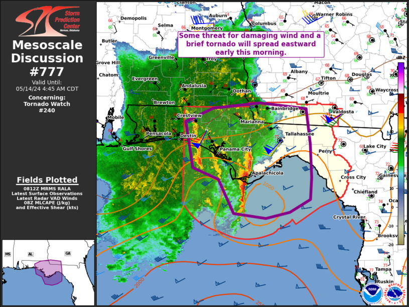
   Mesoscale Discussion 0777
   NWS Storm Prediction Center Norman OK
   0314 AM CDT Tue May 14 2024

   Areas affected...Parts of the FL Panhandle into extreme southwest GA

   Concerning...Tornado Watch 240...

   Valid 140814Z - 140945Z

   The severe weather threat for Tornado Watch 240 continues.

   SUMMARY...Some threat for damaging wind and a brief tornado will
   spread eastward through the early morning.

   DISCUSSION...Satellite and radar trends indicate that an earlier
   well-developed MCS over the northeast Gulf of Mexico has experienced
   some loss in organization and intensity, with warming cloud tops and
   at least a temporary loss of the earlier more well-defined bowing
   structure. This is likely due to the MCS moving through a region of
   relatively weaker instability, generally along/north of the
   effective surface front.

   However, some reintensification of this system cannot be ruled out
   through the early morning. Notable low-level recovery was noted
   between the 00Z and 06Z TLH soundings, with an increase of 2 g/kg in
   the lowest 100 mb mean mixing ratio. Observed temperatures and
   dewpoints remain in the low 70s F from the immediate coastline into
   eastern parts of the Panhandle, sufficient to support MLCAPE of
   500-1000 J/kg. Rather strong deep-layer shear will continue to
   support organized convection, and some potential for damaging wind
   remains evident with any embedded stronger band of convection as the
   MCS moves eastward through the early morning. Also, while low-level
   flow is relatively modest, sufficient veering in the lowest 1-2 km
   may support a threat for a brief tornado.

   ..Dean.. 05/14/2024

   ...Please see www.spc.noaa.gov for graphic product...

   ATTN...WFO...TAE...

   LAT...LON   30718636 30968578 31078479 30958381 30308373 29698370
               29308374 29068416 28968466 29048534 29668566 29878620
               30718636
|
|
Top/All Mesoscale Discussions/Forecast Products/Home
|
|


 @NWSSPC