|
| Mesoscale Discussion 766 |
|
< Previous MD Next MD >
|
|
Mesoscale Discussion 0766
NWS Storm Prediction Center Norman OK
1145 AM CDT Mon May 13 2024
Areas affected...Portions of south-central TX
Concerning...Severe Thunderstorm Watch 235...
Valid 131645Z - 131815Z
The severe weather threat for Severe Thunderstorm Watch 235
continues.
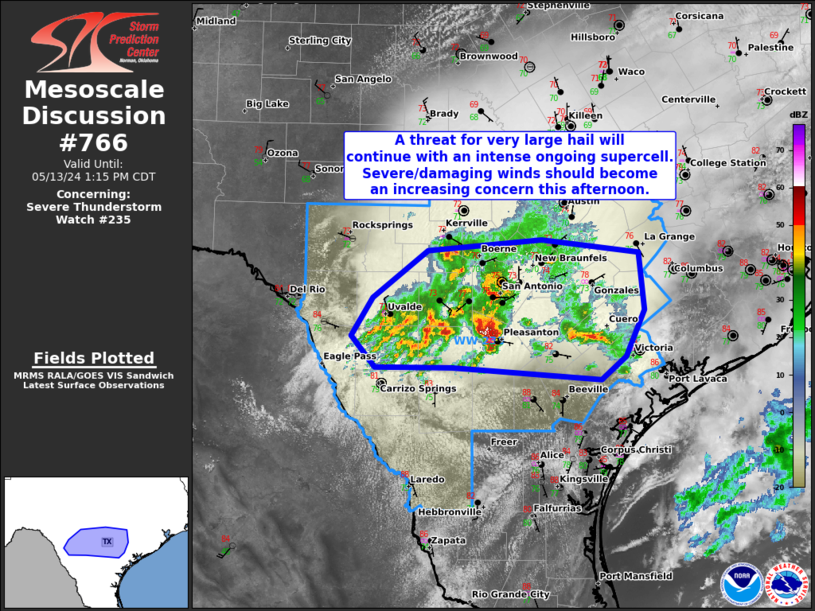
SUMMARY...A threat for very large hail will continue with ongoing
supercells. Severe/damaging winds should become an increasing
concern this afternoon as convection attempts to grow upscale into a
bowing cluster.
DISCUSSION...An intense supercell is ongoing to the south of the San
Antonio TX metro as of 1635Z. With extreme instability present
(4000+ J/kg MUCAPE), along with strong deep-layer shear of 45-50 kt,
a supercell mode will likely be maintained in the short term. Steep
mid-level lapse rates noted on area 12Z soundings from DRT/CRP/BRO
will aid robust updraft accelerations and a threat for large to very
large hail, potentially up to 2-3 inches in diameter. To the north
of this supercell into central TX, destructive updraft
interference/interactions have occurred, with a messier storm mode
observed and a lesser threat for large hail. With time, expectations
are for convection to gradually grow upscale into a small bowing
cluster as activity continues eastward through the afternoon. A
greater threat for severe/damaging winds of 60-70 mph should exist
once this mode transition occurs.
..Gleason.. 05/13/2024
...Please see www.spc.noaa.gov for graphic product...
ATTN...WFO...CRP...EWX...
LAT...LON 29369992 29849930 29949802 29829692 29259685 28799707
28559734 28679902 28679989 28990016 29369992
|
|
Top/All Mesoscale Discussions/Forecast Products/Home
|
|


 @NWSSPC