|
| Mesoscale Discussion 765 |
|
< Previous MD Next MD >
|
|
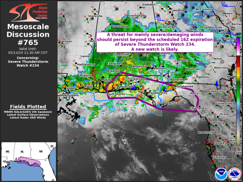
   Mesoscale Discussion 0765
   NWS Storm Prediction Center Norman OK
   1028 AM CDT Mon May 13 2024

   Areas affected...Portions of far southern AL into the FL Panhandle

   Concerning...Severe Thunderstorm Watch 234...

   Valid 131528Z - 131630Z

   The severe weather threat for Severe Thunderstorm Watch 234
   continues.

   SUMMARY...A threat for mainly severe/damaging winds should persist
   beyond the scheduled 16Z expiration of Severe Thunderstorm Watch
   234. A new watch will likely be needed.

   DISCUSSION...A small bowing cluster with a history of producing
   severe winds up to 54 kt is ongoing across parts of far
   southern/coastal AL into the western FL Panhandle. Latest surface
   observations show boundary extends eastward from this cluster very
   near/along the FL Panhandle Coast. A moist low-level airmass is
   present along/south of this boundary, with surface dewpoints
   generally in the upper 60s to low 70s. Even modest/filtered heating
   of his moist airmass will support at least weak boundary-layer
   destabilization, with MLCAPE generally 500-1000 J/kg per recent
   mesoanalysis estimates. VWPs from KEVX/KTLH show a
   veering/strengthening wind profile with height through mid/upper
   levels. Ample low-level and deep-layer shear will support continued
   organization of the ongoing cluster in the short term, with
   severe/damaging winds remaining the primary threat as convection
   spreads eastward across much of the FL Panhandle through this
   afternoon. But, some concern also exists regarding embedded/QLCS
   tornado potential, as 0-1 km shear is sufficient for low-level
   updraft rotation. With WW 234 scheduled to expire at 16Z, and the
   threat likely to continue this afternoon, a new watch is likely.

   ..Gleason.. 05/13/2024

   ...Please see www.spc.noaa.gov for graphic product...

   ATTN...WFO...TAE...MOB...

   LAT...LON   30508777 31148704 30688486 30358346 29958314 29418329
               29558509 30038631 29988761 30508777
|
|
Top/All Mesoscale Discussions/Forecast Products/Home
|
|


 @NWSSPC