|
| Mesoscale Discussion 764 |
|
< Previous MD Next MD >
|
|
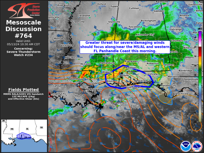
   Mesoscale Discussion 0764
   NWS Storm Prediction Center Norman OK
   0900 AM CDT Mon May 13 2024

   Areas affected...Portions of coastal MS/AL into the western FL
   Panhandle

   Concerning...Severe Thunderstorm Watch 234...

   Valid 131400Z - 131530Z

   The severe weather threat for Severe Thunderstorm Watch 234
   continues.

   SUMMARY...A greater threat for severe/damaging winds should focus
   along the Mississippi/Alabama Coast into the western Florida
   Panhandle this morning.

   DISCUSSION...A small bowing cluster is ongoing over southern/coastal
   AL this morning. A warm front is draped east-southeastward across
   southern AL into the western FL Panhandle based on latest surface
   observations. Recent velocity data from KMOB show strong inbound
   velocities at low levels. A greater threat for severe/damaging winds
   should be focused along and south of the warm front into parts of
   the western FL Panhandle, where there will be a better likelihood
   for downdraft winds to reach the surface. Enhanced low-level flow
   and strong boundary-layer shear noted on recent VWPs from KMOB may
   also support some threat for an embedded tornado.

   ..Gleason.. 05/13/2024

   ...Please see www.spc.noaa.gov for graphic product...

   ATTN...WFO...TAE...MOB...LIX...

   LAT...LON   30808891 31018846 31308785 30998676 30768626 30398604
               30188628 30248711 30118797 30228860 30378884 30808891
|
|
Top/All Mesoscale Discussions/Forecast Products/Home
|
|


 @NWSSPC