|
| Mesoscale Discussion 630 |
|
< Previous MD Next MD >
|
|
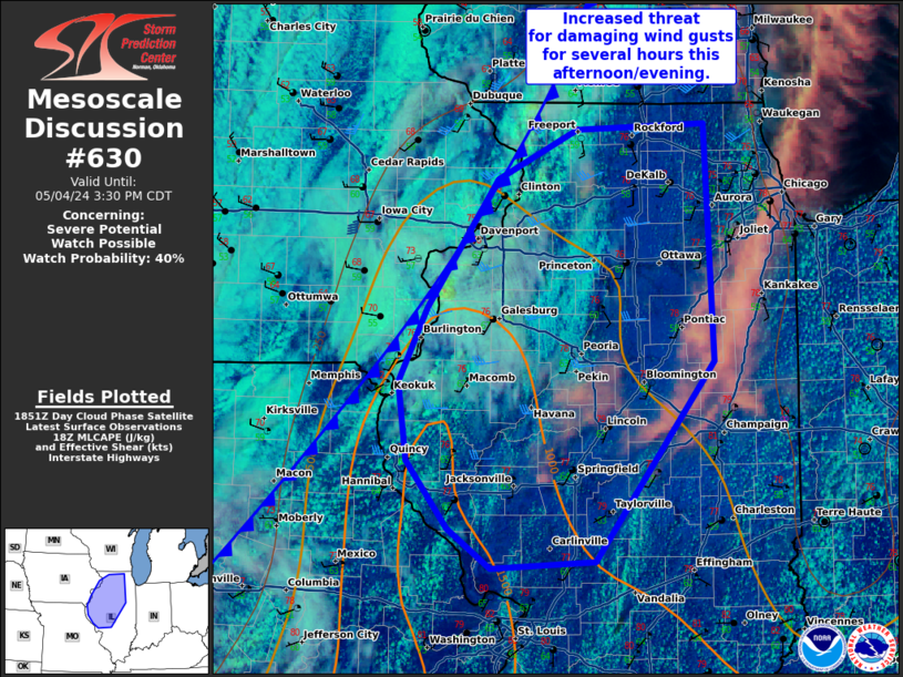
   Mesoscale Discussion 0630
   NWS Storm Prediction Center Norman OK
   0156 PM CDT Sat May 04 2024

   Areas affected...northern and western Illinois.

   Concerning...Severe potential...Watch possible

   Valid 041856Z - 042030Z

   Probability of Watch Issuance...40 percent

   SUMMARY...There is an increased threat for damaging wind gusts from
   thunderstorms for several hours this afternoon/evening.

   DISCUSSION...RAP mesoanalysis shows a mostly uncapped airmass ahead
   of a cold front moving across the Midwest. Expect destabilization to
   increase through the afternoon as mid-60s dewpoints continue to
   advect into the region and temperatures warm into the low 80s.
   Substantial instability (~1500-2000 J/kg MLCAPE) and modest
   deep-layer shear (25-30 knots per DVN VWP) will lead to some loosely
   organized multicell thunderstorms along the front later this
   afternoon. Near peak heating (~21Z), there may be a few hour window
   with strong to severe thunderstorms with a primary threat of
   damaging wind gusts. However, this threat is expected to be mainly
   driven by daytime heating and therefore, the threat should wane by
   dusk. Convective trends will be monitored, and if decent storm
   coverage and intensity appears imminent, a severe thunderstorm watch
   will be considered.

   ..Bentley/Smith.. 05/04/2024

   ...Please see www.spc.noaa.gov for graphic product...

   ATTN...WFO...LOT...ILX...LSX...DVN...

   LAT...LON   39139043 39429084 39919124 40479132 41029104 41959038
               42318962 42348840 40638832 39188944 39139043
|
|
Top/All Mesoscale Discussions/Forecast Products/Home
|
|


 @NWSSPC