|
| Mesoscale Discussion 629 |
|
< Previous MD Next MD >
|
|
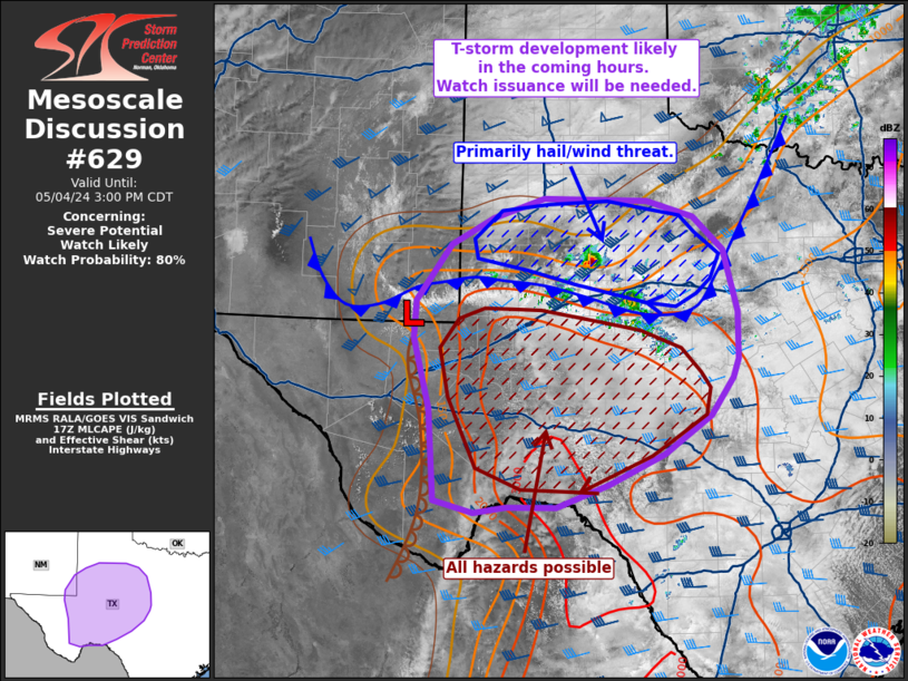
   Mesoscale Discussion 0629
   NWS Storm Prediction Center Norman OK
   1236 PM CDT Sat May 04 2024

   Areas affected...West to southwest Texas

   Concerning...Severe potential...Watch likely

   Valid 041736Z - 042000Z

   Probability of Watch Issuance...80 percent

   SUMMARY...Thunderstorm development along a southward-surging cold
   front is likely within the next 1-2 hours with additional convection
   expected later this afternoon across southwest TX. Given a favorable
   environment for organized severe convection, one or more watches
   will likely be needed in the coming hours.

   DISCUSSION...Transient convection, along with a more robust cell
   near Snyder, TX, is noted along and just behind a surface cold front
   per regional radar and GOES visible/IR imagery at around 17:30 UTC.
   Aside from the Snyder, TX cell, this convection has been short-lived
   so far, likely owing to rapid displacement of initial updrafts onto
   the cool side of the boundary. The development of additional
   deep/robust convection is probable in the next couple of hours as
   the downstream air mass continues to destabilize. Initial cells will
   continue to be displaced along/behind the boundary given
   boundary-parallel mean flow and post-frontal deep-layer shear
   vectors. However, MUCAPE within the post-frontal air mass coupled
   with elongated hodographs should support a few more intense storms
   capable of large to very large hail.

   Further south ahead of the cold front, RAP mesoanalyses suggests
   MLCIN is slowly eroding. However, convective initiation appears less
   imminent based on latest visible imagery trends. Morning CAM
   guidance suggests thunderstorm development along/ahead of the
   dryline is most probable during the 18-21 UTC period closer to peak
   diurnal heating and as modest ascent ahead of an approaching upper
   wave overspreads the region. Thunderstorms developing within the
   warm sector (most likely off the Davis Mountains where shallow
   cumulus is beginning to develop) will likely evolve into high-based
   supercells with a risk for large to very large hail. The tornado
   risk is expected to increase through late afternoon and early
   evening as cells migrate eastward into an increasingly moist air
   mass with strengthening southeasterly winds (which should bolster
   effective SRH to around 150 m2/s2).

   Given these two regimes, a severe thunderstorm watch will likely be
   needed for locations north of the cold front with a tornado watch
   required for areas south of the boundary. Convective trends along
   the cold front and dryline/higher terrain will continue to be
   monitored to determine exact timing of either watch issuance.

   ..Moore/Smith.. 05/04/2024

   ...Please see www.spc.noaa.gov for graphic product...

   ATTN...WFO...FWD...EWX...SJT...LUB...MAF...

   LAT...LON   29670283 29820339 30930348 31810370 32270368 32960318
               33290257 33530184 33490034 33299967 32899924 32139904
               31559905 31329913 30869945 30390011 30010091 29740166
               29730237 29670283
|
|
Top/All Mesoscale Discussions/Forecast Products/Home
|
|


 @NWSSPC