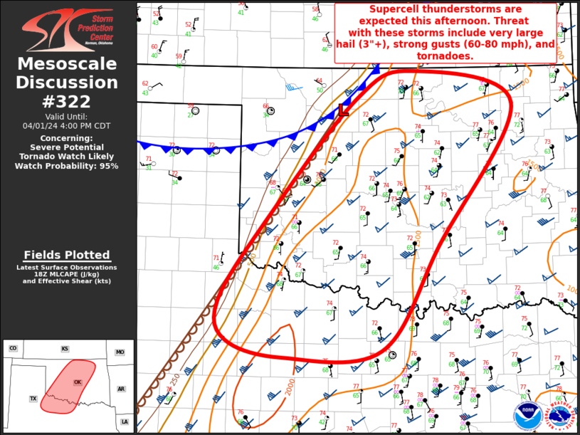
   Mesoscale Discussion 0322
   NWS Storm Prediction Center Norman OK
   0155 PM CDT Mon Apr 01 2024

   Areas affected...Much of OK and Northwest TX

   Concerning...Severe potential...Tornado Watch likely

   Valid 011855Z - 012100Z

   Probability of Watch Issuance...95 percent

   SUMMARY...Supercell thunderstorms are expected this afternoon from
   northwest Texas across much of Oklahoma. Threat with these storms
   will include very large hail (3"+), strong gusts (60-80 mph), and
   tornadoes.

   DISCUSSION...Recent surface analysis places a triple point low about
   20 miles west-northwest of END, with dryline extending southwestward
   from this low through southwest OK and into southwest TX.
   Thunderstorms have developed in the vicinity of this surface low,
   amid persistent low-level convergence and warm-air advection. There
   is still some low-level stability remaining within the air mass. As
   such, this initial development is likely elevated, but steep
   mid-level lapse rates and strong deep-layer vertical shear are more
   than sufficient for updraft organization. Large to very large (1" to
   2.75") is possible with this activity.

   Continued low-level moisture advection and filtered heating will
   likely lead to gradual air mass destabilization, with additional
   storms developing later this afternoon along and ahead of the
   dryline as the shortwave (and associated ascent) continues to lift
   northeastward. This activity would likely be surface based and
   capable of all severe hazards, including very large hail (3"+),
   strong gusts (60-80 mph), and tornadoes. A Tornado Watch will be
   issued soon to cover these potential hazards.

   ..Mosier/Thompson.. 04/01/2024

   ...Please see www.spc.noaa.gov for graphic product...

   ATTN...WFO...TSA...FWD...OUN...SJT...LUB...

   LAT...LON   33209930 33420019 33930032 34989958 36599812 36969723
               36529563 34689682 33309774 33209930
|


 @NWSSPC