|
| Mesoscale Discussion 323 |
|
< Previous MD Next MD >
|
|
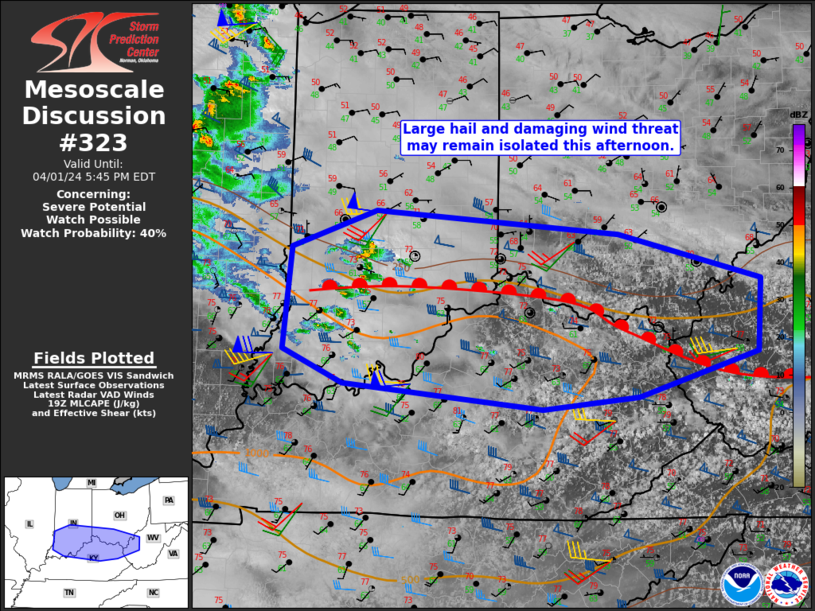
   Mesoscale Discussion 0323
   NWS Storm Prediction Center Norman OK
   0246 PM CDT Mon Apr 01 2024

   Areas affected...Portions of Middle/Upper Ohio Valley

   Concerning...Severe potential...Watch possible

   Valid 011946Z - 012145Z

   Probability of Watch Issuance...40 percent

   SUMMARY...Should storms develop/mature, large hail and damaging
   winds will be possible. Storm coverage may remain isolated this
   afternoon and the need for a watch is not certain. Convective trends
   will be monitored.

   DISCUSSION...Destabilization continues along/south of a warm front
   within the Ohio Valley vicinity. A few weak convective cores within
   southern Indiana continue eastward. These storms may be capable of
   small hail. Continued heating/warm advection within the frontal zone
   may lead to additional storms along the boundary. Effective shear of
   40-50 kts and MLCAPE of 500-1000 J/kg will mean potentially
   organized storms, should they mature. The main uncertainty is how
   intense these storms will become given neutral to modest mid-level
   height rises this afternoon. A watch is not anticipated in the short
   term, but convective trends will be monitored. A more substantial
   severe threat is expected later this evening/overnight.

   ..Wendt/Thompson.. 04/01/2024

   ...Please see www.spc.noaa.gov for graphic product...

   ATTN...WFO...RLX...JKL...ILN...LMK...IND...PAH...ILX...

   LAT...LON   37838298 37708422 37858556 37978682 38308760 39358750
               39728640 39488323 39028139 38288144 37838298
|
|
Top/All Mesoscale Discussions/Forecast Products/Home
|
|


 @NWSSPC