|
| Mesoscale Discussion 321 |
|
< Previous MD Next MD >
|
|
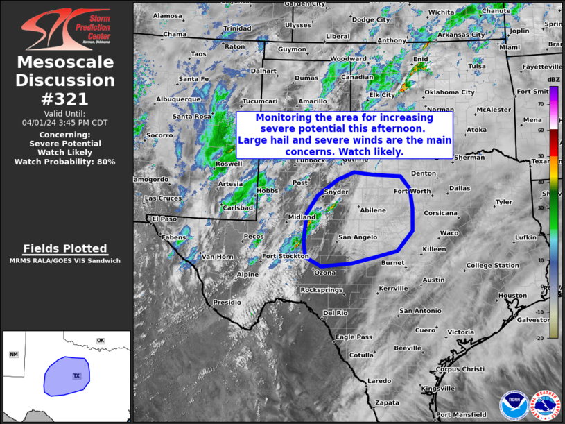
   Mesoscale Discussion 0321
   NWS Storm Prediction Center Norman OK
   0213 PM CDT Mon Apr 01 2024

   Areas affected...Parts of west and central Texas

   Concerning...Severe potential...Watch likely

   Valid 011913Z - 012045Z

   Probability of Watch Issuance...80 percent

   SUMMARY...Monitoring the area for increasing severe-storm potential.
   Large hail and severe gusts are the main concerns. A watch is likely
   in the next 30 minutes or so.

   DISCUSSION...Isolated storms are developing along the dryline this
   afternoon, and this activity will generally spread
   east-northeastward through the afternoon -- in conjunction with an
   approaching lobe of midlevel ascent. While initial storms may be
   high-based with a localized severe risk, the risk will gradually
   increase over the next few hours as storms move into moderate/strong
   surface-based buoyancy and rapidly increasing deep-layer shear.
   Generally straight hodographs will favor large to very large hail
   and severe winds with supercells and organized clusters. A watch is
   likely in the next 30 minutes or so.

   ..Weinman/Thompson.. 04/01/2024

   ...Please see www.spc.noaa.gov for graphic product...

   ATTN...WFO...FWD...SJT...LUB...MAF...

   LAT...LON   31450151 32240142 32750107 33190040 33399988 33339928
               33279834 32929804 32379797 31769798 31209847 31039919
               30879994 30780094 31030144 31450151
|
|
Top/All Mesoscale Discussions/Forecast Products/Home
|
|


 @NWSSPC