|
| Mesoscale Discussion 198 |
|
< Previous MD Next MD >
|
|
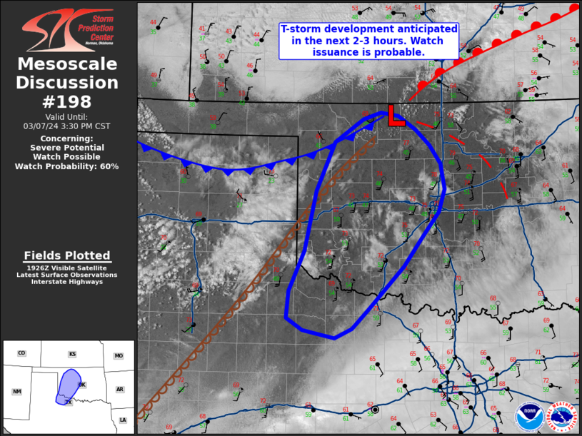
   Mesoscale Discussion 0198
   NWS Storm Prediction Center Norman OK
   0130 PM CST Thu Mar 07 2024

   Areas affected...Central and western Oklahoma into northwest Texas

   Concerning...Severe potential...Watch possible

   Valid 071930Z - 072130Z

   Probability of Watch Issuance...60 percent

   SUMMARY...Thunderstorm development is anticipated in the coming
   hours. These storms will initially pose a large hail threat before
   transitioning to primarily a severe wind threat during the evening
   hours. Watch issuance is probable.

   DISCUSSION...Surface observations over the past few hours have shown
   gradual moisture return into western OK ahead of a sharpening
   dryline/surface trough. Although this moisture is somewhat meager
   (low to mid 50 dewpoints), steep mid-level lapse rates continue to
   overspread the region amid a west/southwesterly mid-level flow
   regime. While MLCAPE remains very minimal at the moment, continued
   low-level moisture return should result in gradually improving
   buoyancy through the late afternoon and evening hours. Regardless,
   ascent associated with a subtle mid-level perturbation is
   overspreading the TX Panhandle with high-based cumulus development
   noted behind the dryline. This ascent is forecast to reach the warm
   sector across western OK/northwest TX in the coming hours, and
   recent HRRR/WOFS runs suggest initiation is likely during the 21-23
   UTC period. Although convection may initially be anemic owing to the
   modest buoyancy, the severe threat should steadily increase heading
   into the evening hours with initially discrete cells posing a large
   hail risk across northwest TX/western OK before upscale growth
   favors an increasing wind threat further east into central OK. Watch
   issuance is probable in the coming hours as sufficient buoyancy
   becomes established to support severe convection.

   ..Moore/Hart.. 03/07/2024

   ...Please see www.spc.noaa.gov for graphic product...

   ATTN...WFO...OUN...LUB...

   LAT...LON   34180013 34789986 35689964 36419931 36759878 36869847
               36809814 36609783 36379758 36099737 35719730 35379741
               35009772 34559806 33909871 33629900 33499931 33579970
               33619988 33780017 34180013
|
|
Top/All Mesoscale Discussions/Forecast Products/Home
|
|


 @NWSSPC